La Fontenelle (La Fontenelle)

- commune in Loir-et-Cher, France
- Country:

- Postal Code: 41270
- Coordinates: 48° 3' 36" N, 1° 1' 28" E


- GPS tracks (wikiloc): [Link]
- Area: 20.1 sq km
- Population: 193
- Wikipedia en: wiki(en)
- Wikipedia: wiki(fr)
- Wikidata storage: Wikidata: Q1096227
- Wikipedia Commons Category: [Link]
- Freebase ID: [/m/03qd2jz]
- GeoNames ID: Alt: [6456888]
- SIREN number: [214100893]
- BnF ID: [15259365t]
- INSEE municipality code: 41089
Shares border with regions:

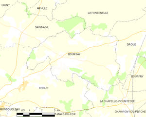
Boursay
- commune in Loir-et-Cher, France
- Country:
- Postal Code: 41270
- Coordinates: 48° 1' 9" N, 0° 58' 9" E
- GPS tracks (wikiloc): [Link]
- Area: 22.08 sq km
- Population: 173


Le Gault-du-Perche
- commune in Loir-et-Cher, France
- Country:
- Postal Code: 41270
- Coordinates: 48° 5' 42" N, 0° 58' 46" E
- GPS tracks (wikiloc): [Link]
- AboveSeaLevel: 228 м m
- Area: 28.2 sq km
- Population: 330

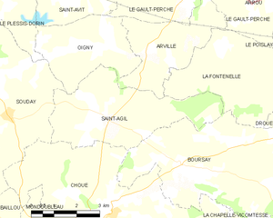
Saint-Agil
- former commune in Loir-et-Cher, France
- Country:
- Postal Code: 41170
- Coordinates: 48° 2' 9" N, 0° 55' 33" E
- GPS tracks (wikiloc): [Link]
- Area: 15.61 sq km
- Population: 270

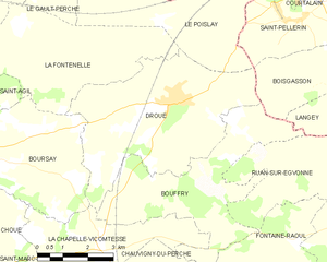
Droué
- commune in Loir-et-Cher, France
- Country:
- Postal Code: 41270
- Coordinates: 48° 2' 26" N, 1° 4' 34" E
- GPS tracks (wikiloc): [Link]
- Area: 24.04 sq km
- Population: 986
- Web site: [Link]


Le Poislay
- commune in Loir-et-Cher, France
- Country:
- Postal Code: 41270
- Coordinates: 48° 4' 2" N, 1° 3' 59" E
- GPS tracks (wikiloc): [Link]
- Area: 15.89 sq km
- Population: 189


Arville
- former commune in Loir-et-Cher, France
- Country:
- Postal Code: 41170
- Coordinates: 48° 3' 46" N, 0° 56' 50" E
- GPS tracks (wikiloc): [Link]
- Area: 9.75 sq km
- Population: 80