Nus (Nus)
- Italian comune
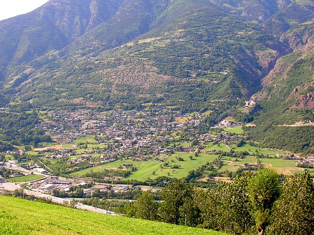
Nus, a charming village located in the Aosta Valley region of Italy, offers some wonderful hiking opportunities. The picturesque landscape is characterized by mountains, valleys, and lush greenery, making it a great destination for outdoor enthusiasts. Here are some key points about hiking in Nus:
Trails and Routes
-
Sentiero del Castello: This scenic trail leads hikers to the ruins of an ancient castle, providing stunning views of the Aosta Valley. The hike is relatively easy, making it suitable for families.
-
Mont Avic Natural Park: While the park extends beyond Nus, it's a short drive away and features numerous trails ranging from easy walks to more challenging hikes. The park is known for its diverse flora and fauna, as well as beautiful lakes and waterfalls.
-
Cogne Valley: If you're willing to travel a bit further, the Cogne Valley offers spectacular trails with breathtaking views. The trails here vary in difficulty, catering to all skill levels.
Best Time to Hike
The best hiking season is typically from late spring to early autumn (May to September), when the weather is milder and trails are mostly clear of snow. However, always check local conditions, especially in mountain areas, as weather can change rapidly.
Gear and Preparation
- Footwear: A good pair of hiking boots is essential for comfort and safety on uneven terrain.
- Clothing: Dress in layers to accommodate changing weather conditions, and don’t forget a rain jacket.
- Navigation: While some trails are well-marked, carrying a map or using a hiking app on your smartphone is advised.
Safety Tips
- Always inform someone about your hiking plans.
- Be mindful of wildlife and respect nature.
- Carry sufficient water and snacks.
- Start hikes early to avoid afternoon storms common in mountainous regions.
Nus is not just about hiking; it also offers rich cultural experiences, local cuisine, and historical sites. Enjoy your adventure in this beautiful part of Italy!
- Country:

- Postal Code: 11020
- Local Dialing Code: 0165
- Licence Plate Code: AO
- Coordinates: 45° 44' 0" N, 7° 28' 0" E


- GPS tracks (wikiloc): [Link]
- AboveSeaLevel: 529 м m
- Area: 57.36 sq km
- Population: 2991
- Web site: http://www.comune.nus.ao.it/
- Wikipedia en: wiki(en)
- Wikipedia: wiki(it)
- Wikidata storage: Wikidata: Q35231
- Wikipedia Commons Gallery: [Link]
- Wikipedia Commons Category: [Link]
- Wikipedia Commons Maps Category: [Link]
- Freebase ID: [/m/0dm1vt]
- GeoNames ID: Alt: [6543061]
- OSM relation ID: [45955]
- ISTAT ID: 007045
- Italian cadastre code: F987
Shares border with regions:


Bionaz
- Italian comune
Bionaz is a picturesque valley located in the Aosta Valley region of Italy, offering stunning landscapes, charming scenery, and a variety of hiking opportunities. Here’s what you need to know about hiking in Bionaz:...
- Country:

- Postal Code: 11010
- Local Dialing Code: 0165
- Licence Plate Code: AO
- Coordinates: 45° 52' 0" N, 7° 25' 0" E


- GPS tracks (wikiloc): [Link]
- AboveSeaLevel: 1606 м m
- Area: 142.09 sq km
- Population: 235
- Web site: [Link]

Fénis
- Italian comune
Fénis is a picturesque village located in the Aosta Valley region of Italy, known for its stunning landscapes, rich history, and outdoor activities, making it an excellent destination for hiking enthusiasts. Here are some key points to consider when exploring hiking in Fénis:...
- Country:

- Postal Code: 11020
- Local Dialing Code: 0165
- Licence Plate Code: AO
- Coordinates: 45° 44' 5" N, 7° 29' 44" E


- GPS tracks (wikiloc): [Link]
- AboveSeaLevel: 541 м m
- Area: 68.12 sq km
- Population: 1818
- Web site: [Link]


Oyace
- Italian comune
Oyace is a picturesque village located in the Aosta Valley region of Italy, surrounded by stunning alpine scenery. It offers various hiking opportunities for outdoor enthusiasts. Here’s an overview of what you can expect when hiking in and around Oyace:...
- Country:

- Postal Code: 11010
- Local Dialing Code: 0165
- Licence Plate Code: AO
- Coordinates: 45° 51' 0" N, 7° 23' 0" E


- GPS tracks (wikiloc): [Link]
- AboveSeaLevel: 1377 м m
- Area: 30.56 sq km
- Population: 211
- Web site: [Link]


Quart, Aosta Valley
- Italian comune
Quart is a charming municipality in the Aosta Valley region of Italy, nestled in the foothills of the Alps. It offers a variety of hiking opportunities that cater to different skill levels and preferences. Here’s an overview of what you can expect when hiking in Quart:...
- Country:

- Postal Code: 11020
- Local Dialing Code: 0165
- Licence Plate Code: AO
- Coordinates: 45° 44' 0" N, 7° 25' 0" E


- GPS tracks (wikiloc): [Link]
- AboveSeaLevel: 535 м m
- Area: 62.05 sq km
- Population: 4066
- Web site: [Link]


Saint-Marcel, Aosta Valley
- Italian comune
 Hiking in Saint-Marcel, Aosta Valley
Saint-Marcel, located in the Aosta Valley region of Italy, is a beautiful area for hiking enthusiasts, offering stunning landscapes typical of the Alps. The valley is known for its breathtaking views, natural beauty, and a variety of hiking trails that cater to different skill levels....
- Country:

- Postal Code: 11020
- Local Dialing Code: 0165
- Licence Plate Code: AO
- Coordinates: 45° 43' 53" N, 7° 26' 54" E


- GPS tracks (wikiloc): [Link]
- AboveSeaLevel: 625 м m
- Area: 42.38 sq km
- Population: 1348
- Web site: [Link]


Torgnon
- Italian comune
Torgnon is a beautiful village located in the Aosta Valley region of Italy, nestled in the Italian Alps. It's known for its stunning landscapes, lush valleys, and pristine nature, making it an ideal destination for hiking enthusiasts. Here are some key points about hiking in Torgnon:...
- Country:

- Postal Code: 11020
- Local Dialing Code: 0166
- Licence Plate Code: AO
- Coordinates: 45° 48' 0" N, 7° 34' 0" E


- GPS tracks (wikiloc): [Link]
- AboveSeaLevel: 1489 м m
- Area: 42.46 sq km
- Population: 587
- Web site: [Link]


Verrayes
- Italian comune
Verrayes is a beautiful municipality located in the Aosta Valley region of Italy. It's known for its stunning landscapes, charming villages, and the surrounding mountains, which offer a variety of hiking opportunities suitable for different skill levels. Here are some key points about hiking in Verrayes:...
- Country:

- Postal Code: 11020
- Local Dialing Code: 0166
- Licence Plate Code: AO
- Coordinates: 45° 46' 0" N, 7° 32' 0" E


- GPS tracks (wikiloc): [Link]
- AboveSeaLevel: 1017 м m
- Area: 22.36 sq km
- Population: 1303
- Web site: [Link]
