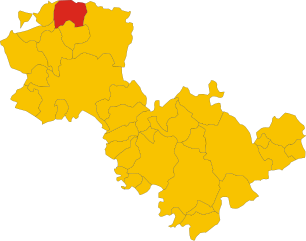
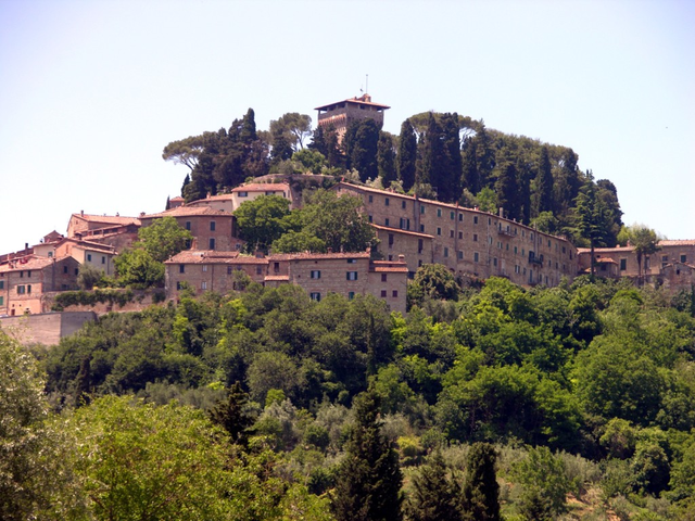
Fabro (Fabro)
.svg)
- town in the region Umbria, in Italy
 Hiking in Fabro
Fabro is a charming medieval town located in the Umbria region of Italy. While it may not be as widely recognized for hiking as some larger national parks, it offers access to beautiful landscapes, picturesque trails, and a rich cultural backdrop that can make for a unique hiking experience.
Hiking Opportunities in and Around Fabro:
-
Surrounding Nature: The area around Fabro features rolling hills, vineyards, and olive groves typical of the Umbrian countryside. This scenic terrain provides numerous opportunities for short walks or longer hikes.
-
Paths and Trails: There are several paths that connect Fabro with nearby towns and natural sites. Walking these routes allows hikers to experience the rustic charm of the landscape, as well as enjoy views of the Val di Chiana valley.
-
Monte Amiata: A bit further from Fabro, Monte Amiata offers more rugged hiking trails and higher elevations. It's a perfect option for those looking for a more challenging hike amidst the beautiful southern Tuscan terrain.
-
Cultural Trails: Consider incorporating hikes that allow you to explore local culture. Some trails might take you through historical sites, ancient ruins, or vineyards where you can stop and taste local wines and produce.
-
Nature Reserves: Exploring nearby natural reserves can be a great way to enjoy the local flora and fauna. Check out local maps for designated paths and trails in these areas.
Practical Tips:
-
Best Time to Hike: Spring and early fall are ideal for hiking in this region due to the mild weather and blooming landscapes.
-
Equipment: Wear sturdy hiking shoes, and bring enough water, sun protection, and snacks.
-
Guided Tours: Consider joining a guided hiking tour to learn more about the area’s history and natural features from knowledgeable local guides.
-
Local Resources: Visit local tourist offices or websites for maps and information about current trail conditions, as well as seasonal events that may be occurring.
Whether you are looking for a leisurely stroll or a more vigorous hike, Fabro and its surrounding areas can offer an enjoyable experience combined with stunning views and cultural richness. Happy hiking!
- Country:

- Postal Code: 05015
- Local Dialing Code: 0763
- Licence Plate Code: TR
- Coordinates: 42° 52' 0" N, 12° 1' 0" E


- GPS tracks (wikiloc): [Link]
- AboveSeaLevel: 364 м m
- Area: 34.55 sq km
- Population: 2828
- Web site: http://www.comune.fabro.tr.it
- Wikipedia en: wiki(en)
- Wikipedia: wiki(it)
- Wikidata storage: Wikidata: Q8711
- Wikipedia Commons Category: [Link]
- Freebase ID: [/m/0gm2y7]
- GeoNames ID: Alt: [6538622]
- VIAF ID: Alt: [134487089]
- OSM relation ID: [42204]
- UN/LOCODE: [ITFAB]
- Facebook Places ID: [107975902557372]
- ISTAT ID: 055011
- Italian cadastre code: D454
Shares border with regions:


Ficulle
- town in the region Umbria, in Italy
Hiking in Ficulle
Ficulle is a charming village located in the Umbria region of Italy, surrounded by beautiful landscapes and rolling hills. Hiking in this area provides an opportunity to explore picturesque trails, enjoy stunning views, and experience the rich natural and cultural heritage of the region....
- Country:
- Postal Code: 05016
- Local Dialing Code: 0763
- Licence Plate Code: TR
- Coordinates: 42° 50' 0" N, 12° 4' 0" E
- GPS tracks (wikiloc): [Link]
- AboveSeaLevel: 437 м m
- Area: 64.62 sq km
- Population: 1634
- Web site: [Link]

Montegabbione
- town in the region Umbria, in Italy
Hiking in Montegabbione
Montegabbione is a charming village located in the Umbria region of Italy, known for its beautiful landscapes, rich history, and outdoor activities, including hiking. The area offers various trails that provide an opportunity to explore the stunning natural beauty of the Umbrian countryside....
- Country:
- Postal Code: 05010
- Local Dialing Code: 0763
- Licence Plate Code: TR
- Coordinates: 42° 55' 0" N, 12° 5' 0" E
- GPS tracks (wikiloc): [Link]
- AboveSeaLevel: 594 м m
- Area: 51.06 sq km
- Population: 1177
- Web site: [Link]

Monteleone d'Orvieto
- town in the region Umbria, in Italy
Hiking in Monteleone d'Orvieto
Monteleone d'Orvieto is a charming hilltop town located in the Umbria region of Italy. It's surrounded by beautiful landscapes and offers a variety of hiking opportunities that cater to different skill levels. Here are some details about hiking in this picturesque area:...
- Country:
- Postal Code: 05017
- Local Dialing Code: 0763
- Licence Plate Code: TR
- Coordinates: 42° 55' 0" N, 12° 3' 0" E
- GPS tracks (wikiloc): [Link]
- AboveSeaLevel: 500 м m
- Area: 24.1 sq km
- Population: 1429
- Web site: [Link]


Città della Pieve
- Italian comune
Hiking in Città della Pieve
Città della Pieve, located in the Umbria region of Italy, is a charming hilltop town known for its stunning landscapes, historic architecture, and rich cultural heritage. Hiking in this area offers a mix of scenic views, rolling hills, vineyards, and olive groves, making it an appealing destination for outdoor enthusiasts....
- Country:
- Postal Code: 06062
- Local Dialing Code: 0578
- Licence Plate Code: PG
- Coordinates: 42° 57' 14" N, 12° 0' 28" E
- GPS tracks (wikiloc): [Link]
- AboveSeaLevel: 508 м m
- Area: 110.94 sq km
- Population: 7686
- Web site: [Link]


Allerona
- town in the region Umbria, in Italy
Hiking in Allerona
Allerona is a charming town located in the province of Terni, in the Umbria region of Italy. It is set in a beautiful natural landscape, characterized by rolling hills, vineyards, olive groves, and lush forests, making it a fantastic destination for hikers and nature lovers....
- Country:
- Postal Code: 05011
- Local Dialing Code: 0763
- Licence Plate Code: TR
- Coordinates: 42° 49' 0" N, 11° 58' 0" E
- GPS tracks (wikiloc): [Link]
- AboveSeaLevel: 472 м m
- Area: 82.61 sq km
- Population: 1769
- Web site: [Link]

Cetona
- Italian comune
Hiking in Cetona
Cetona is a beautiful town located in the Tuscany region of Italy, known for its stunning landscapes and rich history. The area surrounding Cetona offers several hiking opportunities that cater to different skill levels, making it a great destination for outdoor enthusiasts....
- Country:
- Postal Code: 53040
- Local Dialing Code: 0578
- Licence Plate Code: SI
- Coordinates: 42° 58' 0" N, 11° 54' 0" E
- GPS tracks (wikiloc): [Link]
- AboveSeaLevel: 350 м m
- Area: 53.57 sq km
- Population: 2678
- Web site: [Link]


San Casciano dei Bagni
- Italian comune
Hiking in San Casciano dei Bagni
San Casciano dei Bagni, located in the stunning region of Tuscany, Italy, is not only known for its relaxing thermal baths but also for its beautiful hiking opportunities. The surrounding landscape is characterized by rolling hills, charming vineyards, olive groves, and the picturesque Val d'Orcia. Here’s a guide to hiking in this picturesque area:...
- Country:
- Postal Code: 53040
- Local Dialing Code: 0578
- Licence Plate Code: SI
- Coordinates: 42° 52' 0" N, 11° 53' 0" E
- GPS tracks (wikiloc): [Link]
- AboveSeaLevel: 582 м m
- Area: 92.14 sq km
- Population: 1601
- Web site: [Link]