
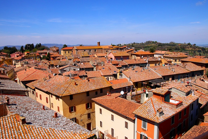
Cetona (Cetona)
.svg)
- Italian comune
 Hiking in Cetona
Cetona is a beautiful town located in the Tuscany region of Italy, known for its stunning landscapes and rich history. The area surrounding Cetona offers several hiking opportunities that cater to different skill levels, making it a great destination for outdoor enthusiasts.
Hiking Trails
-
Monte Cetona: This is the main peak in the area and provides a popular hiking trail that rewards hikers with stunning panoramic views. The trail is moderately challenging and climbs through cypress forests and lovely meadows. It usually takes around 3-4 hours to reach the summit.
-
Val d'Orcia Trails: Nearby, the Val d'Orcia region is famous for its rolling hills, vineyards, and beautiful landscapes. There are numerous trails that meander through this UNESCO World Heritage site, allowing hikers to enjoy the scenery and perhaps stop by a vineyard for a tasting.
-
Path of the Etruscans: This is an ancient path that offers a combination of history and nature. The trail connects various historical sites in the Etruscan area and provides a unique perspective on the region's past.
-
Sienese Hills: Explore the hills surrounding the town, where trails can be found that vary from easy walks to more strenuous hikes. These paths can lead you through olive groves and vineyards, providing a quintessential Tuscan experience.
Tips for Hiking in Cetona
- Best Time to Hike: Spring (April to June) and early autumn (September to October) are ideal for hiking, as temperatures are mild and the landscapes are particularly beautiful.
- Proper Gear: Make sure to wear sturdy hiking shoes, carry a water bottle, and dress in layers to adapt to changing weather conditions.
- Navigation: While many trails are well-marked, carrying a map or using hiking apps can be helpful. Some areas can be remote, so it's best to be prepared.
- Local Guides: Consider hiring a local guide for unique insights into the area’s flora, fauna, and history, as well as for securing a safe and enjoyable experience.
- Respect Nature: Follow Leave No Trace principles, and be sure to stick to marked trails to help protect the local ecosystem.
Hiking in Cetona offers a wonderful blend of outdoor adventure, breathtaking scenery, and cultural experiences, making it a fantastic choice for anyone looking to explore Tuscany on foot!
- Country:

- Postal Code: 53040
- Local Dialing Code: 0578
- Licence Plate Code: SI
- Coordinates: 42° 58' 0" N, 11° 54' 0" E


- GPS tracks (wikiloc): [Link]
- AboveSeaLevel: 350 м m
- Area: 53.57 sq km
- Population: 2678
- Web site: http://www.comune.cetona.siena.it
- Wikipedia en: wiki(en)
- Wikipedia: wiki(it)
- Wikidata storage: Wikidata: Q91160
- Wikipedia Commons Category: [Link]
- Freebase ID: [/m/071h86]
- GeoNames ID: Alt: [6536848]
- VIAF ID: Alt: [314817707]
- OSM relation ID: [42228]
- GND ID: Alt: [4401190-8]
- WOEID: [713903]
- Quora topic ID: [Cetona]
- UN/LOCODE: [ITCE7]
- ISTAT ID: 052008
- Italian cadastre code: C587
Shares border with regions:


Città della Pieve
- Italian comune
Hiking in Città della Pieve
Città della Pieve, located in the Umbria region of Italy, is a charming hilltop town known for its stunning landscapes, historic architecture, and rich cultural heritage. Hiking in this area offers a mix of scenic views, rolling hills, vineyards, and olive groves, making it an appealing destination for outdoor enthusiasts....
- Country:
- Postal Code: 06062
- Local Dialing Code: 0578
- Licence Plate Code: PG
- Coordinates: 42° 57' 14" N, 12° 0' 28" E
- GPS tracks (wikiloc): [Link]
- AboveSeaLevel: 508 м m
- Area: 110.94 sq km
- Population: 7686
- Web site: [Link]


Fabro
- town in the region Umbria, in Italy
Hiking in Fabro
Fabro is a charming medieval town located in the Umbria region of Italy. While it may not be as widely recognized for hiking as some larger national parks, it offers access to beautiful landscapes, picturesque trails, and a rich cultural backdrop that can make for a unique hiking experience....
- Country:
- Postal Code: 05015
- Local Dialing Code: 0763
- Licence Plate Code: TR
- Coordinates: 42° 52' 0" N, 12° 1' 0" E
- GPS tracks (wikiloc): [Link]
- AboveSeaLevel: 364 м m
- Area: 34.55 sq km
- Population: 2828
- Web site: [Link]

Chiusi
- Italian comune
Hiking in Chiusi
Chiusi, a charming town in the Tuscany region of Italy, is not only rich in history and culture but also offers some beautiful hiking opportunities. Nestled in the rolling hills and surrounded by picturesque landscapes, Chiusi serves as an excellent base for exploring the natural beauty of the area. Here are some highlights and tips for hiking in and around Chiusi:...
- Country:
- Postal Code: 53043
- Local Dialing Code: 0578
- Licence Plate Code: SI
- Coordinates: 43° 1' 0" N, 11° 57' 0" E
- GPS tracks (wikiloc): [Link]
- AboveSeaLevel: 398 м m
- Area: 58.15 sq km
- Population: 8558
- Web site: [Link]


San Casciano dei Bagni
- Italian comune
Hiking in San Casciano dei Bagni
San Casciano dei Bagni, located in the stunning region of Tuscany, Italy, is not only known for its relaxing thermal baths but also for its beautiful hiking opportunities. The surrounding landscape is characterized by rolling hills, charming vineyards, olive groves, and the picturesque Val d'Orcia. Here’s a guide to hiking in this picturesque area:...
- Country:
- Postal Code: 53040
- Local Dialing Code: 0578
- Licence Plate Code: SI
- Coordinates: 42° 52' 0" N, 11° 53' 0" E
- GPS tracks (wikiloc): [Link]
- AboveSeaLevel: 582 м m
- Area: 92.14 sq km
- Population: 1601
- Web site: [Link]


Sarteano
- Italian comune
Hiking in Sarteano
Sarteano is a charming town located in the Valdichiana area of Tuscany, Italy. Known for its stunning landscapes, medieval architecture, and rich history, Sarteano is an excellent base for hiking enthusiasts looking to explore the picturesque Tuscan countryside....
- Country:
- Postal Code: 53047
- Local Dialing Code: 0578
- Licence Plate Code: SI
- Coordinates: 42° 59' 0" N, 11° 52' 0" E
- GPS tracks (wikiloc): [Link]
- AboveSeaLevel: 525 м m
- Area: 84.81 sq km
- Population: 4705
- Web site: [Link]