Faymont (Faymont)

- commune in Haute-Saône, France
- Country:

- Postal Code: 70200
- Coordinates: 47° 36' 34" N, 6° 35' 39" E


- GPS tracks (wikiloc): [Link]
- Area: 7.99 sq km
- Population: 261
- Wikipedia en: wiki(en)
- Wikipedia: wiki(fr)
- Wikidata storage: Wikidata: Q918980
- Wikipedia Commons Category: [Link]
- Freebase ID: [/m/03nvtdv]
- GeoNames ID: Alt: [6441934]
- SIREN number: [217002294]
- BnF ID: [152726223]
- INSEE municipality code: 70229
Shares border with regions:

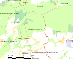
Granges-le-Bourg
- commune in Haute-Saône, France
- Country:
- Postal Code: 70400
- Coordinates: 47° 33' 54" N, 6° 35' 9" E
- GPS tracks (wikiloc): [Link]
- Area: 10.35 sq km
- Population: 383


Courmont
- commune in Haute-Saône, France
- Country:
- Postal Code: 70400
- Coordinates: 47° 36' 43" N, 6° 37' 43" E
- GPS tracks (wikiloc): [Link]
- Area: 6.39 sq km
- Population: 119


Mignavillers
- commune in Haute-Saône, France
- Country:
- Postal Code: 70400
- Coordinates: 47° 34' 50" N, 6° 33' 6" E
- GPS tracks (wikiloc): [Link]
- Area: 7.59 sq km
- Population: 337


Lomont
- commune in Haute-Saône, France
- Country:
- Postal Code: 70200
- Coordinates: 47° 37' 27" N, 6° 36' 50" E
- GPS tracks (wikiloc): [Link]
- Area: 11.35 sq km
- Population: 436


Saulnot
- commune in Haute-Saône, France
 Hiking in Saulnot
Saulnot is a quaint village located in the Bourgogne-Franche-Comté region of France, surrounded by beautiful natural landscapes that make it an appealing destination for hiking enthusiasts. The area offers a mix of scenic trails that cater to various skill levels, from leisurely walks to more challenging hikes....
- Country:
- Postal Code: 70400
- Coordinates: 47° 33' 45" N, 6° 38' 0" E
- GPS tracks (wikiloc): [Link]
- Area: 26.73 sq km
- Population: 748
- Web site: [Link]