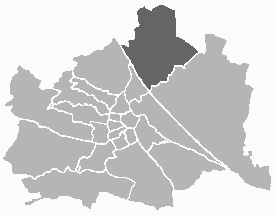
Donaustadt (Donaustadt)

- 22. district of Vienna, Austria
 Hiking in Donaustadt
Donaustadt is a district in Vienna, Austria, located along the banks of the Danube River. It offers a unique combination of urban and natural landscapes, making it an attractive destination for hikers. Here are some highlights and tips for hiking in Donaustadt:
Trails and Nature
-
Danube Island (Donauinsel): This is a popular recreation area with a long and scenic island stretching for several kilometers along the Danube River. It features a network of walking and biking paths, picnic areas, and opportunities for water sports. The paths are well-maintained and suitable for both casual walkers and more experienced hikers.
-
Nationalpark Donau-Auen: Just a short distance from Donaustadt, this national park preserves the natural wetland environment along the Danube. It offers a variety of trails that take you through lush forests, meadows, and along the riverbanks. Birdwatching and wildlife observation are excellent here.
-
Lobau: Lobau is a part of the Vienna Woods and is situated within the national park. It has several trails ranging from easy to moderate difficulty. The area is rich in biodiversity and is a great spot for nature lovers.
Tips for Hiking in Donaustadt
-
Prepare for Weather: The weather in Vienna can change quickly, so it's essential to check the forecast before heading out. Dress in layers and bring waterproof gear if needed.
-
Footwear: Wear comfortable hiking shoes with good grip, especially if you plan to explore more rugged areas within the national park or Lobau.
-
Hydration and Snacks: Always carry water and some energy snacks, especially if you're planning on hiking longer trails.
-
Public Transport: Donaustadt is accessible by public transport, including U-Bahn (subway) and trams, making it easy to reach various trailheads.
-
Respect Nature: Follow local regulations, stay on marked trails, and practice Leave No Trace principles to preserve the beautiful environment.
Nearby Attractions
-
Kunst Haus Wien: Don’t miss this art museum designed by Friedensreich Hundertwasser, which is located nearby. It offers a great cultural complement to your hiking experience.
-
Danube Tower (Donauturm): After your hike, consider visiting this tower for panoramic views of the city and the Danube River.
Donaustadt offers a wonderful blend of urban and natural hiking experiences, making it suitable for both locals and visitors looking to reconnect with nature while enjoying the sights of Vienna.
- Country:

- Postal Code: 1220
- Licence Plate Code: W
- Coordinates: 48° 13' 5" N, 16° 28' 59" E


- GPS tracks (wikiloc): [Link]
- AboveSeaLevel: 152 м m
- Area: 102.29 sq km
- Web site: http://www.wien.gv.at/bezirke/donaustadt/
- Wikipedia en: wiki(en)
- Wikipedia: wiki(de)
- Wikidata storage: Wikidata: Q258333
- Wikipedia Commons Gallery: [Link]
- Wikipedia Commons Category: [Link]
- Freebase ID: [/m/06m_b4]
- GeoNames ID: Alt: [2780851]
- VIAF ID: Alt: [168009861]
- GND ID: Alt: [4108152-3]
- archINFORM location ID: [3702]
- Library of Congress authority ID: Alt: [n97122976]
- TGN ID: [1004372]
- Austrian municipality key: [92201]
Shares border with regions:


Leopoldstadt
- 2nd municipal District of Vienna, Austria
Hiking in Leopoldstadt
Leopoldstadt is the second district of Vienna, Austria, known for its vibrant culture, parks, and proximity to the Danube River. While it may not offer traditional hiking trails found in mountainous regions, there are still great opportunities for outdoor activities and leisurely walks....
- Country:
- Postal Code: 1020
- Licence Plate Code: W
- Coordinates: 48° 12' 37" N, 16° 24' 44" E
- GPS tracks (wikiloc): [Link]
- AboveSeaLevel: 158 м m
- Area: 19.27 sq km
- Web site: [Link]

Floridsdorf
- 21. district of Vienna
Hiking in Floridsdorf
Floridsdorf is one of the 23 districts of Vienna, Austria, and while it is primarily an urban area, there are some lovely opportunities for outdoor activities and hiking in and around the district. Here are some highlights for hiking enthusiasts:...
- Country:
- Postal Code: 1210
- Licence Plate Code: W
- Coordinates: 48° 17' 0" N, 16° 24' 44" E
- GPS tracks (wikiloc): [Link]
- AboveSeaLevel: 159 м m
- Area: 44.52 sq km
- Web site: [Link]


Simmering
- 11. district of Vienna
Hiking in Simmering
Simmering is a district in the southeastern part of Vienna, and while it is primarily an urban area, there are some opportunities for enjoyable walks and light hiking in the vicinity. Here are some key points to consider for anyone wanting to explore hiking-like experiences in and around Simmering:...
- Country:
- Postal Code: 1110
- Licence Plate Code: W
- Coordinates: 48° 10' 12" N, 16° 27' 0" E
- GPS tracks (wikiloc): [Link]
- AboveSeaLevel: 156 м m
- Area: 23.27 sq km
- Population: 97333
- Web site: [Link]

Lower Austria
- federated state of Austria
Hiking in Lower Austria
Lower Austria, known as Niederösterreich in German, is a fantastic destination for hiking enthusiasts. The region is characterized by its diverse landscapes, including rolling hills, vineyards, forests, and the scenic Danube River. Here are some highlights and popular hiking areas in Lower Austria:...
- Country:
- Capital: St. Pölten
- Coordinates: 48° 20' 0" N, 15° 45' 0" E
- GPS tracks (wikiloc): [Link]
- AboveSeaLevel: 279 м m
- Area: 19186.0 sq km
- Population: 1653419
- Web site: [Link]


Wien-Umgebung District
- former district of the state of Lower Austria in Austria
Hiking in Wien-Umgebung District
Wien-Umgebung, or the Vienna Surroundings District, offers a variety of beautiful hiking opportunities right outside the bustling capital of Austria. Here are some highlights and features of hiking in this region:...
- Country:
- Capital: Klosterneuburg
- Licence Plate Code: WU
- Coordinates: 48° 18' 0" N, 16° 19' 0" E
- GPS tracks (wikiloc): [Link]
- AboveSeaLevel: 346 м m
- Area: 484.48 sq km
- Web site: [Link]


Gänserndorf District
- district of Austria
Hiking in Gänserndorf District
Gänserndorf District, located in the northeastern part of Austria, offers a variety of hiking opportunities that showcase its scenic beauty and rich natural landscapes. Here are some aspects to consider when planning a hiking trip in this area:...
- Country:
- Licence Plate Code: GF
- Coordinates: 48° 20' 28" N, 16° 43' 5" E
- GPS tracks (wikiloc): [Link]
- AboveSeaLevel: 173 м m
- Area: 1271.31 sq km
- Web site: [Link]