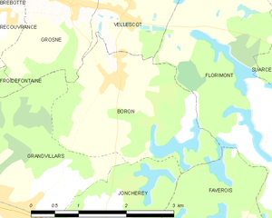
Florimont (Florimont)
- commune in Territoire de Belfort, France
Florimont, often known for its natural beauty and stunning landscapes, is a great destination for hiking enthusiasts. While specific trails and conditions may vary, here are some general aspects and recommendations for hiking in the area:
Scenic Trails
-
Variety of Terrain: Florimont offers a mix of terrains, from gentle hills to rugged mountain trails. This variety means that hikers of all skill levels can find suitable routes.
-
Well-Marked Trails: The trails are usually well-maintained and marked, making navigation easier for hikers. Be sure to look out for local maps at trailheads or visitor centers.
-
Panoramic Views: Many hikes feature stunning vistas at lookout points, providing opportunities for photography and enjoying the natural beauty of the region.
Hiking Tips
-
Prepare for the Weather: Weather can change quickly in mountainous areas. Check the forecast before your hike and dress in layers. Bring waterproof gear if necessary.
-
Stay Hydrated and Snack Smart: Carry enough water and high-energy snacks to keep your energy up during your hike.
-
Wildlife Awareness: Florimont may be home to various wildlife. Be respectful of their habitat, and know how to respond if you encounter animals.
-
Leave No Trace: Follow Leave No Trace principles to minimize your impact on the environment. Pack out what you pack in.
Popular Routes
Some specific trails may include:
- Mountain summits: Offering challenging hikes with rewarding views.
- Lakeside trails: For more leisurely hikes with beautiful water views.
- Nature loops: Ideal for families and beginners, often featuring educational signage about local flora and fauna.
Safety Considerations
- Know Your Limits: Choose trails that match your fitness level and experience.
- Hike with a Buddy: Whenever possible, hike with a partner for safety.
- Cell Service: Be mindful that cell service may be limited or nonexistent in remote areas.
Local Resources
Before heading out, consider visiting a local outdoor shop or visitor center for trail maps, advice on current trail conditions, and any permits that may be required.
Hiking in Florimont can be an enriching experience, combining physical activity with the beauty of nature. Enjoy your adventure!
- Country:

- Postal Code: 90100
- Coordinates: 47° 30' 39" N, 7° 4' 5" E


- GPS tracks (wikiloc): [Link]
- Area: 18.19 sq km
- Population: 457
- Wikipedia en: wiki(en)
- Wikipedia: wiki(fr)
- Wikidata storage: Wikidata: Q843506
- Wikipedia Commons Category: [Link]
- Freebase ID: [/m/03mh9l2]
- Freebase ID: [/m/03mh9l2]
- Freebase ID: [/m/03mh9l2]
- GeoNames ID: Alt: [6615259]
- GeoNames ID: Alt: [6615259]
- GeoNames ID: Alt: [6615259]
- SIREN number: [219000460]
- SIREN number: [219000460]
- SIREN number: [219000460]
- BnF ID: [152799876]
- BnF ID: [152799876]
- BnF ID: [152799876]
- Global Anabaptist Mennonite Encyclopedia Online ID: [Florimont (Franche-Comté, France)]
- Global Anabaptist Mennonite Encyclopedia Online ID: [Florimont (Franche-Comté, France)]
- Global Anabaptist Mennonite Encyclopedia Online ID: [Florimont (Franche-Comté, France)]
- INSEE municipality code: 90046
- INSEE municipality code: 90046
- INSEE municipality code: 90046
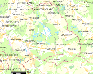
Shares border with regions:

Boron
- commune in Territoire de Belfort, France
Boron, located in the Territoire de Belfort region of France, offers a unique hiking experience amidst picturesque landscapes. The area is characterized by rolling hills, forests, and views of the nearby Belfort’s Lion, a famous landmark that commemorates the city’s history....
- Country:

- Postal Code: 90100
- Coordinates: 47° 33' 40" N, 7° 0' 37" E


- GPS tracks (wikiloc): [Link]
- Area: 6.05 sq km
- Population: 463


Delle
- commune in Territoire de Belfort, France
Delle, located in the Doubs department of France, is a charming town that serves as a gateway to some wonderful hiking opportunities in the Jura Mountains and surrounding countryside. Here’s what you should know about hiking in this region:...
- Country:

- Postal Code: 90100
- Coordinates: 47° 30' 25" N, 6° 59' 53" E


- GPS tracks (wikiloc): [Link]
- Area: 9.2 sq km
- Population: 5749
- Web site: [Link]


Courtelevant
- commune in Territoire de Belfort, France
Courtelevant, located in the picturesque region of Switzerland, offers numerous opportunities for hiking enthusiasts. The area is known for its stunning landscapes, including rolling hills, dense forests, and sweeping views of the surrounding mountains....
- Country:

- Postal Code: 90100
- Coordinates: 47° 31' 2" N, 7° 4' 48" E


- GPS tracks (wikiloc): [Link]
- Area: 5.82 sq km
- Population: 431


Courcelles
- commune in Territoire de Belfort, France
Courcelles, located in the Territoire de Belfort department in the Bourgogne-Franche-Comté region of France, offers some beautiful hiking opportunities. This area is known for its picturesque landscapes, lush forests, and proximity to the Vosges mountains, making it ideal for both casual walkers and more experienced hikers....
- Country:

- Postal Code: 90100
- Coordinates: 47° 29' 54" N, 7° 4' 35" E


- GPS tracks (wikiloc): [Link]
- Area: 5.32 sq km
- Population: 134


Chavannes-les-Grands
- commune in Territoire de Belfort, France
 Hiking in Chavannes-les-Grands
Chavannes-les-Grands is a beautiful area in Switzerland, known for its picturesque landscapes and outdoor activities, including hiking. Situated in the Jura Mountains, it provides stunning views of both the mountains and the nearby Lake Geneva. Here are some aspects to consider when hiking in Chavannes-les-Grands:...
- Country:

- Postal Code: 90100
- Coordinates: 47° 35' 28" N, 7° 2' 49" E


- GPS tracks (wikiloc): [Link]
- Area: 6.93 sq km
- Population: 335

Chavanatte
- commune in Territoire de Belfort, France
Chavanatte is a lesser-known but beautiful hiking destination that offers a unique experience for outdoor enthusiasts. Nestled in the scenic landscapes, it typically features diverse terrain, such as lush forests, rolling hills, and possibly serene water bodies. Though specific details about Chavanatte may vary depending on the region and country you are referring to, here are some general points to consider when hiking in such areas:...
- Country:

- Postal Code: 90100
- Coordinates: 47° 34' 47" N, 7° 4' 1" E


- GPS tracks (wikiloc): [Link]
- Area: 3.86 sq km
- Population: 158

Faverois
- commune in Territoire de Belfort, France
Faverois, a picturesque area in France, offers a range of hiking opportunities for both beginners and experienced trekkers. The region is known for its stunning natural scenery, including rolling hills, dense forests, and panoramic views. Here are some highlights for hiking in Faverois:...
- Country:

- Postal Code: 90100
- Coordinates: 47° 31' 20" N, 7° 2' 9" E


- GPS tracks (wikiloc): [Link]
- Area: 6.5 sq km
- Population: 578


Suarce
- commune in Territoire de Belfort, France
Suarce is a charming destination for hiking enthusiasts in the Auvergne region of France. The area offers a variety of trails that cater to different skill levels, making it suitable for both beginners and experienced hikers. Here are some highlights of hiking in Suarce:...
- Country:

- Postal Code: 90100
- Coordinates: 47° 33' 49" N, 7° 4' 53" E


- GPS tracks (wikiloc): [Link]
- Area: 11.81 sq km
- Population: 448


Vellescot
- commune in Territoire de Belfort, France
Vellescot might not be widely known in tourism circles, and specific information about hiking trails in that area is limited. However, if it’s a local region or a lesser-known hiking spot, here are some general tips for hiking in unfamiliar areas that might apply:...
- Country:

- Postal Code: 90100
- Coordinates: 47° 34' 21" N, 7° 0' 50" E


- GPS tracks (wikiloc): [Link]
- Area: 3.55 sq km
- Population: 268
