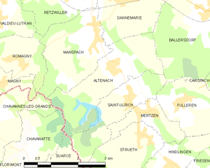
Suarce (Suarce)

- commune in Territoire de Belfort, France
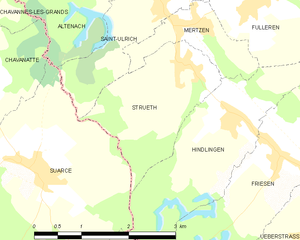
 Hiking in Suarce
Suarce is a charming destination for hiking enthusiasts in the Auvergne region of France. The area offers a variety of trails that cater to different skill levels, making it suitable for both beginners and experienced hikers. Here are some highlights of hiking in Suarce:
Scenic Trails
-
Forests and Natural Landscapes: The region is characterized by lush forests, rolling hills, and stunning views of the surrounding countryside. Many trails wind through dense woods, offering a serene walking experience.
-
Wildlife: Hikers can often spot a variety of local wildlife, including deer, various bird species, and other wildlife native to rural France.
-
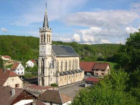
Historic Sites: Some hiking trails may lead to historic landmarks, such as old ruins or churches that are interspersed throughout the region, adding a cultural touch to your outdoor adventure.
Trail Recommendations
-
Beginner Trails: There are easier routes suitable for families and novice hikers, often with well-marked paths and stunning viewpoints.
-
Challenging Trails: For experienced hikers, there are more demanding trails that offer greater elevation changes and longer distances.
Best Time to Hike
The best time for hiking in Suarce is during the spring and early autumn months when temperatures are mild, and the natural scenery is at its peak. Summers can be hot, while winters may bring snow, limiting access to certain trails.
Preparation and Safety
- Gear: Ensure you have appropriate hiking boots, weather-appropriate clothing, and enough water and snacks for your trek.
- Navigation: Many trails are marked, but having a map or a GPS device can be helpful.
- Local Regulations: Be mindful of any local regulations regarding trail usage and wildlife protection.
Local Amenities
After a long day of hiking, you can explore local eateries or stay in small inns or guesthouses that provide a cozy place to rest.
Remember to check local resources or hiking guides for specific trail maps and updates before heading out. Enjoy your hike in Suarce!
- Country:

- Postal Code: 90100
- Coordinates: 47° 33' 49" N, 7° 4' 53" E


- GPS tracks (wikiloc): [Link]
- Area: 11.81 sq km
- Population: 448
- Wikipedia en: wiki(en)
- Wikipedia: wiki(fr)
- Wikidata storage: Wikidata: Q914309
- Wikipedia Commons Category: [Link]
- Freebase ID: [/m/03mhh3k]
- Freebase ID: [/m/03mhh3k]
- Freebase ID: [/m/03mhh3k]
- GeoNames ID: Alt: [6451938]
- GeoNames ID: Alt: [6451938]
- GeoNames ID: Alt: [6451938]
- SIREN number: [219000957]
- SIREN number: [219000957]
- SIREN number: [219000957]
- BnF ID: [15280036v]
- BnF ID: [15280036v]
- BnF ID: [15280036v]
- INSEE municipality code: 90095
- INSEE municipality code: 90095
- INSEE municipality code: 90095
Shares border with regions:

Altenach
- commune in Haut-Rhin, France
Hiking in Altenach
Altenach is a picturesque location that offers a variety of hiking opportunities, ideal for both beginners and experienced hikers. Nestled in a scenic area, Altenach features beautiful landscapes, including lush forests, rolling hills, and breathtaking views....
- Country:
- Postal Code: 68210
- Coordinates: 47° 36' 24" N, 7° 6' 43" E
- GPS tracks (wikiloc): [Link]
- Area: 6.18 sq km
- Population: 378


Hindlingen
- commune in Haut-Rhin, France
Hiking in Hindlingen
Hindlingen is a lesser-known destination for hiking enthusiasts, likely appealing to those looking for less crowded trails and a chance to connect with nature. While I don't have specific information about hiking trails in Hindlingen itself, here are some general tips for hiking in less-explored areas:...
- Country:
- Postal Code: 68580
- Coordinates: 47° 34' 18" N, 7° 8' 14" E
- GPS tracks (wikiloc): [Link]
- Area: 8 sq km
- Population: 649

Strueth
- commune in Haut-Rhin, France
Hiking in Strueth
Strueth is a lesser-known destination for hiking enthusiasts, so it's important to clarify which area you are referring to, as the name may not be widely recognized in hiking literature. However, if you meant the area near a specific region or a town named Strueth, I can give you some general pointers on what to look for in hiking environments in unfamiliar or lesser-explored areas....
- Country:
- Postal Code: 68580
- Coordinates: 47° 35' 0" N, 7° 7' 29" E
- GPS tracks (wikiloc): [Link]
- Area: 4.31 sq km
- Population: 340


Lepuix-Neuf
- commune in Territoire de Belfort, France
Hiking in Lepuix-Neuf
Lepuix-Neuf is a charming village located in the Vosges region of France, known for its stunning landscapes and outdoor activities, making it a great destination for hiking enthusiasts. Here’s what you can expect while hiking in and around Lepuix-Neuf:...
- Country:
- Postal Code: 90100
- Coordinates: 47° 32' 24" N, 7° 5' 58" E
- GPS tracks (wikiloc): [Link]
- Area: 5.46 sq km
- Population: 295


Saint-Ulrich
- commune in Haut-Rhin, France
Hiking in Saint-Ulrich
Saint-Ulrich is a picturesque area that offers several hiking opportunities, particularly known for its stunning landscapes and charming surroundings. While the specific trails can vary based on seasonal conditions and local regulations, I can provide a general overview of what you might expect when hiking in the Saint-Ulrich area....
- Country:
- Postal Code: 68210
- Coordinates: 47° 35' 44" N, 7° 7' 10" E
- GPS tracks (wikiloc): [Link]
- Area: 3.85 sq km
- Population: 308


Courtelevant
- commune in Territoire de Belfort, France
Hiking in Courtelevant
Courtelevant, located in the picturesque region of Switzerland, offers numerous opportunities for hiking enthusiasts. The area is known for its stunning landscapes, including rolling hills, dense forests, and sweeping views of the surrounding mountains....
- Country:
- Postal Code: 90100
- Coordinates: 47° 31' 2" N, 7° 4' 48" E
- GPS tracks (wikiloc): [Link]
- Area: 5.82 sq km
- Population: 431
Florimont
- commune in Territoire de Belfort, France
Hiking in Florimont
Florimont, often known for its natural beauty and stunning landscapes, is a great destination for hiking enthusiasts. While specific trails and conditions may vary, here are some general aspects and recommendations for hiking in the area:...
- Country:
- Postal Code: 90100
- Coordinates: 47° 30' 39" N, 7° 4' 5" E
- GPS tracks (wikiloc): [Link]
- Area: 18.19 sq km
- Population: 457


Chavanatte
- commune in Territoire de Belfort, France
Hiking in Chavanatte
Chavanatte is a lesser-known but beautiful hiking destination that offers a unique experience for outdoor enthusiasts. Nestled in the scenic landscapes, it typically features diverse terrain, such as lush forests, rolling hills, and possibly serene water bodies. Though specific details about Chavanatte may vary depending on the region and country you are referring to, here are some general points to consider when hiking in such areas:...
- Country:
- Postal Code: 90100
- Coordinates: 47° 34' 47" N, 7° 4' 1" E
- GPS tracks (wikiloc): [Link]
- Area: 3.86 sq km
- Population: 158