La Ville-aux-Clercs (La Ville-aux-Clercs)

- commune in Loir-et-Cher, France
- Country:

- Postal Code: 41160
- Coordinates: 47° 55' 6" N, 1° 5' 6" E


- GPS tracks (wikiloc): [Link]
- Area: 26.61 sq km
- Population: 1299
- Wikipedia en: wiki(en)
- Wikipedia: wiki(fr)
- Wikidata storage: Wikidata: Q663861
- Wikipedia Commons Category: [Link]
- Freebase ID: [/m/03nw2zf]
- GeoNames ID: Alt: [3005541]
- SIREN number: [214102758]
- BnF ID: [152595494]
- VIAF ID: Alt: [130362693]
- Library of Congress authority ID: Alt: [n98009438]
- INSEE municipality code: 41275
Shares border with regions:
Chauvigny-du-Perche
- commune in Loir-et-Cher, France
- Country:
- Postal Code: 41270
- Coordinates: 47° 57' 29" N, 1° 4' 47" E
- GPS tracks (wikiloc): [Link]
- Area: 23.43 sq km
- Population: 225


Busloup
- commune in Loir-et-Cher, France
- Country:
- Postal Code: 41160
- Coordinates: 47° 53' 36" N, 1° 7' 55" E
- GPS tracks (wikiloc): [Link]
- Area: 18.94 sq km
- Population: 431

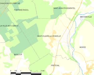
Saint-Hilaire-la-Gravelle
- commune in Loir-et-Cher, France
- Country:
- Postal Code: 41160
- Coordinates: 47° 55' 28" N, 1° 12' 24" E
- GPS tracks (wikiloc): [Link]
- Area: 17.57 sq km
- Population: 716

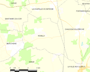
Romilly
- commune in Loir-et-Cher, France
- Country:
- Postal Code: 41270
- Coordinates: 47° 56' 57" N, 1° 2' 20" E
- GPS tracks (wikiloc): [Link]
- Area: 14.9 sq km
- Population: 163


Fontaine-Raoul
- commune in Loir-et-Cher, France
- Country:
- Postal Code: 41270
- Coordinates: 47° 59' 26" N, 1° 8' 20" E
- GPS tracks (wikiloc): [Link]
- Area: 21.9 sq km
- Population: 210
Rahart
- commune in Loir-et-Cher, France
- Country:
- Postal Code: 41160
- Coordinates: 47° 52' 12" N, 1° 4' 3" E
- GPS tracks (wikiloc): [Link]
- Area: 14.23 sq km
- Population: 313

Danzé
- commune in Loir-et-Cher, France
- Country:
- Postal Code: 41160
- Coordinates: 47° 53' 35" N, 1° 1' 40" E
- GPS tracks (wikiloc): [Link]
- Area: 42.26 sq km
- Population: 705
Lisle
- commune in Loir-et-Cher, France
- Country:
- Postal Code: 41100
- Coordinates: 47° 51' 11" N, 1° 6' 58" E
- GPS tracks (wikiloc): [Link]
- Area: 6.61 sq km
- Population: 197