Fossacesia (Fossacesia)
.svg)
- Italian comune
 Hiking in Fossacesia
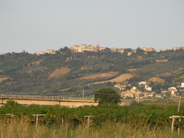
Fossacesia, located in the Abruzzo region of Italy, offers a wonderful setting for hikers due to its diverse landscapes, ranging from coastal views to hilly terrain. Here are some key points to consider if you're planning to hike in this area:
Trails and Natural Features
-
Coastal Trails: Fossacesia is close to the Adriatic Sea, providing beautiful coastal paths. The Trabocchi Coast, with its traditional fishing platforms called 'trabocchi', offers stunning scenery and several trails that meander along the coastline.
-
Parco Naturale Regionale della Majella: On the outskirts of Fossacesia lies this national park, which features a variety of trails suited for different skill levels. The park is known for its rugged mountains, charming forests, and biodiversity, making it a great spot for more adventurous hikes.
-
Rolling Hills and Vineyards: The surrounding hills are dotted with vineyards, olive groves, and charming small villages. You can find trails that take you through these landscapes, allowing you to experience local culture and cuisine along the way.
Hiking Tips
-
Season: Spring and fall are generally the best times to hike in this area, as the weather is mild and the views are particularly beautiful. Summer can be hot, while winters might bring snow in higher elevations.
-
Preparation: Make sure to bring plenty of water, snacks, appropriate footwear, and a map or GPS device. While some trails are well-marked, it’s always good to be prepared.
-
Local Guidance: Consider hiring a local guide or joining a hiking group if you're unfamiliar with the area. They can provide valuable insights about the trails and local flora and fauna.
Cultural Attractions
Along the hiking routes, you'll encounter various cultural landmarks, including old churches, historical sites, and picturesque towns. These make excellent stops to rest and explore the beauty of the region.
Conclusion
Hiking in Fossacesia offers an opportunity to enjoy both nature and culture. Whether you’re hiking along the coast or venturing into the hills, you’ll find a variety of trails that cater to all skill levels and interests. Always remember to respect the natural environment and follow local trail guidelines for a safe and enjoyable experience.
- Country:

- Postal Code: 66022
- Local Dialing Code: 0872
- Licence Plate Code: CH
- Coordinates: 42° 15' 0" N, 14° 29' 0" E


- GPS tracks (wikiloc): [Link]
- AboveSeaLevel: 142 м m
- Area: 30.14 sq km
- Population: 6358
- Web site: http://www.comune.fossacesia.ch.it/
- Wikipedia en: wiki(en)
- Wikipedia: wiki(it)
- Wikidata storage: Wikidata: Q51223
- Wikipedia Commons Category: [Link]
- Freebase ID: [/m/0fg2sx]
- GeoNames ID: Alt: [6541704]
- VIAF ID: Alt: [236136844]
- OSM relation ID: [41866]
- UN/LOCODE: [ITFBZ]
- ISTAT ID: 069033
- Italian cadastre code: D738
Shares border with regions:


Mozzagrogna
- Italian comune
Hiking in Mozzagrogna
Mozzagrogna is a beautiful area located in the Abruzzo region of Italy, offering a variety of landscapes that are perfect for hiking. The region is characterized by rolling hills, vineyards, olive groves, and scenic views of the surrounding countryside and the Majella mountain range....
- Country:
- Postal Code: 66030
- Local Dialing Code: 0872
- Licence Plate Code: CH
- Coordinates: 42° 12' 41" N, 14° 26' 45" E
- GPS tracks (wikiloc): [Link]
- AboveSeaLevel: 223 м m
- Area: 14.1 sq km
- Population: 2444
- Web site: [Link]

Paglieta
- Italian comune
Hiking in Paglieta
Paglieta is a small town located in the Abruzzo region of Italy. While it's not as widely known as some major hiking destinations, it offers access to beautiful landscapes and trails that can appeal to hiking enthusiasts looking for a more off-the-beaten-path experience....
- Country:
- Postal Code: 66020
- Local Dialing Code: 0872
- Licence Plate Code: CH
- Coordinates: 42° 10' 0" N, 14° 30' 0" E
- GPS tracks (wikiloc): [Link]
- AboveSeaLevel: 235 м m
- Area: 33.78 sq km
- Population: 4308
- Web site: [Link]


Rocca San Giovanni
- Italian comune
Hiking in Rocca San Giovanni
Rocca San Giovanni, located in the Abruzzo region of Italy, is a charming village that sits near the stunning Adriatic coast. It's renowned for its beautiful landscapes, historic architecture, and proximity to the Maiella National Park, making it a great destination for hikers....
- Country:
- Postal Code: 66020
- Local Dialing Code: 0872
- Licence Plate Code: CH
- Coordinates: 42° 15' 0" N, 14° 28' 0" E
- GPS tracks (wikiloc): [Link]
- AboveSeaLevel: 150 м m
- Area: 21.7 sq km
- Population: 2333
- Web site: [Link]


Santa Maria Imbaro
- Italian comune
Hiking in Santa Maria Imbaro
Santa Maria Imbaro is a charming village located in the Abruzzo region of Italy, known for its beautiful landscapes and natural beauty. When it comes to hiking in and around Santa Maria Imbaro, you'll find a variety of trails that offer stunning views of the surrounding countryside, the Maiella mountain range, and the Adriatic Sea....
- Country:
- Postal Code: 66030
- Local Dialing Code: 0872
- Licence Plate Code: CH
- Coordinates: 42° 13' 0" N, 14° 27' 0" E
- GPS tracks (wikiloc): [Link]
- AboveSeaLevel: 224 м m
- Area: 5.71 sq km
- Population: 2013
- Web site: [Link]


Torino di Sangro
- Italian comune
Hiking in Torino di Sangro
Torino di Sangro is a charming town located in the Abruzzo region of Italy, nestled between the Adriatic Sea and the foothills of the Apennines. It offers a variety of hiking opportunities that cater to different skill levels, making it an appealing destination for outdoor enthusiasts. Here are some highlights and tips for hiking in and around Torino di Sangro:...
- Country:
- Postal Code: 66020
- Local Dialing Code: 0873
- Licence Plate Code: CH
- Coordinates: 42° 11' 0" N, 14° 32' 0" E
- GPS tracks (wikiloc): [Link]
- AboveSeaLevel: 164 м m
- Area: 32.12 sq km
- Population: 3049
- Web site: [Link]


Lanciano
- Italian comune
Hiking in Lanciano
Lanciano is a charming city in the Abruzzo region of Italy, known for its rich history, beautiful landscapes, and proximity to natural parks, making it a great starting point for hiking enthusiasts....
- Country:
- Postal Code: 66034
- Local Dialing Code: 0872
- Licence Plate Code: CH
- Coordinates: 42° 13' 52" N, 14° 23' 26" E
- GPS tracks (wikiloc): [Link]
- AboveSeaLevel: 265 м m
- Area: 66.94 sq km
- Population: 35002
- Web site: [Link]