
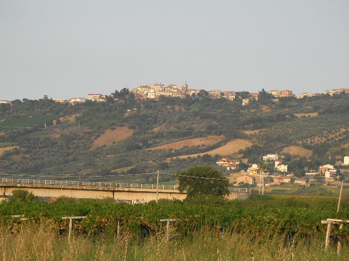
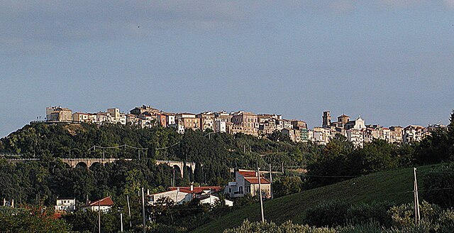
Lanciano (Lanciano)
.svg)
- Italian comune
 Hiking in Lanciano
Lanciano is a charming city in the Abruzzo region of Italy, known for its rich history, beautiful landscapes, and proximity to natural parks, making it a great starting point for hiking enthusiasts.
Hiking Opportunities around Lanciano:
-
Majella National Park: Located to the northwest of Lanciano, this park offers a variety of trails ranging from easy walks to challenging hikes. The scenery includes rugged mountains, deep gorges, and diverse flora and fauna.
-
Gran Sasso and Monti della Laga National Park: A bit further away but accessible for a day trip, this park features some of the highest peaks in the Apennines and offers numerous trails with breathtaking views. Popular hikes include the ascent to Corno Grande, the highest summit.
-
Coastline Trails: The Adriatic coast near Lanciano features beautiful landscapes, including sandy beaches and cliffs. Trails along the coast provide opportunities for scenic walks with views of the sea.
-
Local Trails: There are various smaller trails in the hills surrounding Lanciano, offering a chance to explore vineyards, olive groves, and quaint villages. The area is known for its agricultural landscapes, so you can often enjoy local wine and cuisine during or after your hikes.
Tips for Hiking in the Area:
-
Best Time to Hike: Spring (April to June) and fall (September to October) are the best times for hiking in this region, with mild temperatures and fewer tourists.
-
Equipment: Make sure you have suitable hiking gear, including sturdy boots, weather-appropriate clothing, and plenty of water and snacks.
-
Local Guides: Consider hiring a local hiking guide for the best experience, especially if you're unfamiliar with the area. They can provide insights about the land and ensure you find the best trails.
-
Respect Nature: As in any natural area, it's important to follow Leave No Trace principles. Stick to trails, pack out what you pack in, and be mindful of wildlife.
Overall, hiking around Lanciano offers a wonderful combination of natural beauty, cultural heritage, and gastronomy, making it a fantastic destination for outdoor enthusiasts.
- Country:

- Postal Code: 66034
- Local Dialing Code: 0872
- Licence Plate Code: CH
- Coordinates: 42° 13' 52" N, 14° 23' 26" E


- GPS tracks (wikiloc): [Link]
- AboveSeaLevel: 265 м m
- Area: 66.94 sq km
- Population: 35002
- Web site: http://www.comune.lanciano.chieti.it
- Wikipedia en: wiki(en)
- Wikipedia: wiki(it)
- Wikidata storage: Wikidata: Q8645
- Wikipedia Commons Gallery: [Link]
- Wikipedia Commons Category: [Link]
- Freebase ID: [/m/07d7q2]
- GeoNames ID: Alt: [6541930]
- BnF ID: [13511483h]
- VIAF ID: Alt: [125538427]
- OSM relation ID: [41827]
- GND ID: Alt: [4098975-6]
- archINFORM location ID: [7095]
- MusicBrainz area ID: [ba0a8994-80bd-4dda-913e-c42de5adc5cc]
- Quora topic ID: [Lanciano]
- UN/LOCODE: [ITLCI]
- Encyclopædia Britannica Online ID: [place/Lanciano]
- DMOZ ID: Alt: [Regional/Europe/Italy/Abruzzo/Localities/Lanciano/]
- ISTAT ID: 069046
- Italian cadastre code: E435
Shares border with regions:


Atessa
- Italian comune
Hiking in Atessa
Atessa, located in the Abruzzo region of Italy, offers a range of hiking opportunities that showcase the area's beautiful landscapes, rich history, and cultural heritage. Here are some key points about hiking in Atessa:...
- Country:
- Postal Code: 66041
- Local Dialing Code: 0872
- Licence Plate Code: CH
- Coordinates: 42° 4' 0" N, 14° 27' 0" E
- GPS tracks (wikiloc): [Link]
- AboveSeaLevel: 435 м m
- Area: 110.98 sq km
- Population: 10580
- Web site: [Link]


Castel Frentano
- Italian comune
Hiking in Castel Frentano
Castel Frentano is a picturesque town located in the province of Chieti, in the Abruzzo region of Italy. Surrounded by stunning landscapes, it offers a mix of cultural history and natural beauty, making it an attractive destination for hiking enthusiasts....
- Country:
- Postal Code: 66032
- Local Dialing Code: 0872
- Licence Plate Code: CH
- Coordinates: 42° 12' 0" N, 14° 21' 0" E
- GPS tracks (wikiloc): [Link]
- AboveSeaLevel: 400 м m
- Area: 21.89 sq km
- Population: 4385
- Web site: [Link]


Fossacesia
- Italian comune
Hiking in Fossacesia
Fossacesia, located in the Abruzzo region of Italy, offers a wonderful setting for hikers due to its diverse landscapes, ranging from coastal views to hilly terrain. Here are some key points to consider if you're planning to hike in this area:...
- Country:
- Postal Code: 66022
- Local Dialing Code: 0872
- Licence Plate Code: CH
- Coordinates: 42° 15' 0" N, 14° 29' 0" E
- GPS tracks (wikiloc): [Link]
- AboveSeaLevel: 142 м m
- Area: 30.14 sq km
- Population: 6358
- Web site: [Link]
Frisa
- Italian comune
Hiking in Frisa
Frisa, a small town located in the Abruzzo region of Italy, is surrounded by the beautiful landscapes of the Apennine Mountains and offers a variety of hiking opportunities. Although Frisa itself may not be as widely known for hiking as some of the larger destinations, the surrounding areas boast numerous trails that cater to different skill levels....
- Country:
- Postal Code: 66030
- Local Dialing Code: 0872
- Licence Plate Code: CH
- Coordinates: 42° 16' 0" N, 14° 22' 0" E
- GPS tracks (wikiloc): [Link]
- AboveSeaLevel: 237 м m
- Area: 11.49 sq km
- Population: 1737
- Web site: [Link]


Mozzagrogna
- Italian comune
Hiking in Mozzagrogna
Mozzagrogna is a beautiful area located in the Abruzzo region of Italy, offering a variety of landscapes that are perfect for hiking. The region is characterized by rolling hills, vineyards, olive groves, and scenic views of the surrounding countryside and the Majella mountain range....
- Country:
- Postal Code: 66030
- Local Dialing Code: 0872
- Licence Plate Code: CH
- Coordinates: 42° 12' 41" N, 14° 26' 45" E
- GPS tracks (wikiloc): [Link]
- AboveSeaLevel: 223 м m
- Area: 14.1 sq km
- Population: 2444
- Web site: [Link]
Orsogna
- Italian comune
Hiking in Orsogna
Orsogna is a charming town located in the Abruzzo region of Italy, known for its beautiful landscapes and rich cultural heritage. The surrounding area offers fantastic opportunities for hiking, with a mix of scenic views, rolling hills, vineyards, and historical sites....
- Country:
- Postal Code: 66036
- Local Dialing Code: 0871
- Licence Plate Code: CH
- Coordinates: 42° 13' 0" N, 14° 17' 0" E
- GPS tracks (wikiloc): [Link]
- AboveSeaLevel: 432 м m
- Area: 25.45 sq km
- Population: 3821
- Web site: [Link]

Paglieta
- Italian comune
Hiking in Paglieta
Paglieta is a small town located in the Abruzzo region of Italy. While it's not as widely known as some major hiking destinations, it offers access to beautiful landscapes and trails that can appeal to hiking enthusiasts looking for a more off-the-beaten-path experience....
- Country:
- Postal Code: 66020
- Local Dialing Code: 0872
- Licence Plate Code: CH
- Coordinates: 42° 10' 0" N, 14° 30' 0" E
- GPS tracks (wikiloc): [Link]
- AboveSeaLevel: 235 м m
- Area: 33.78 sq km
- Population: 4308
- Web site: [Link]
Poggiofiorito
- Italian comune
Hiking in Poggiofiorito
Poggiofiorito is a charming village located in the Abruzzo region of Italy, known for its stunning landscapes and rural charm. While it may not be as internationally recognized as some other hiking destinations in Italy, it offers scenic trails and beautiful nature, making it an appealing choice for those looking to explore off the beaten path....
- Country:
- Postal Code: 66030
- Local Dialing Code: 0871
- Licence Plate Code: CH
- Coordinates: 42° 15' 0" N, 14° 19' 0" E
- GPS tracks (wikiloc): [Link]
- AboveSeaLevel: 299 м m
- Area: 9.95 sq km
- Population: 861
- Web site: [Link]


Rocca San Giovanni
- Italian comune
Hiking in Rocca San Giovanni
Rocca San Giovanni, located in the Abruzzo region of Italy, is a charming village that sits near the stunning Adriatic coast. It's renowned for its beautiful landscapes, historic architecture, and proximity to the Maiella National Park, making it a great destination for hikers....
- Country:
- Postal Code: 66020
- Local Dialing Code: 0872
- Licence Plate Code: CH
- Coordinates: 42° 15' 0" N, 14° 28' 0" E
- GPS tracks (wikiloc): [Link]
- AboveSeaLevel: 150 м m
- Area: 21.7 sq km
- Population: 2333
- Web site: [Link]

San Vito Chietino
- Italian comune
Hiking in San Vito Chietino
San Vito Chietino, located in the Abruzzo region of Italy, is a charming coastal town known for its beautiful landscapes, historical sites, and access to the stunning Adriatic Sea. Hiking in this area offers a range of experiences, from coastal trails to inland paths that lead through picturesque villages and natural parks. Here are some highlights of hiking in and around San Vito Chietino:...
- Country:
- Postal Code: 66038
- Local Dialing Code: 0872
- Licence Plate Code: CH
- Coordinates: 42° 18' 0" N, 14° 27' 0" E
- GPS tracks (wikiloc): [Link]
- AboveSeaLevel: 122 м m
- Area: 17 sq km
- Population: 5270
- Web site: [Link]


Sant'Eusanio del Sangro
- Italian comune
Hiking in Sant'Eusanio del Sangro
Sant'Eusanio del Sangro, located in the province of Chieti in the Abruzzo region of Italy, offers a picturesque setting for hiking enthusiasts. This charming village is nestled in the lush landscapes of the Apennine mountains and is surrounded by beautiful countryside, making it an excellent destination for outdoor activities....
- Country:
- Postal Code: 66037
- Local Dialing Code: 0872
- Licence Plate Code: CH
- Coordinates: 42° 10' 0" N, 14° 20' 0" E
- GPS tracks (wikiloc): [Link]
- AboveSeaLevel: 200 м m
- Area: 23.83 sq km
- Population: 2471
- Web site: [Link]
Treglio
- Italian comune
Hiking in Treglio
Treglio is a small town located in the Abruzzo region of Italy, not too far from the Adriatic coast. While Treglio itself may not be a major hiking destination, the surrounding region offers a variety of outdoor activities and breathtaking trails for hikers....
- Country:
- Postal Code: 66030
- Local Dialing Code: 0872
- Licence Plate Code: CH
- Coordinates: 42° 16' 0" N, 14° 25' 0" E
- GPS tracks (wikiloc): [Link]
- AboveSeaLevel: 183 м m
- Area: 4.88 sq km
- Population: 1669
- Web site: [Link]