
Rocca San Giovanni (Rocca San Giovanni)
.svg)
- Italian comune
 Hiking in Rocca San Giovanni
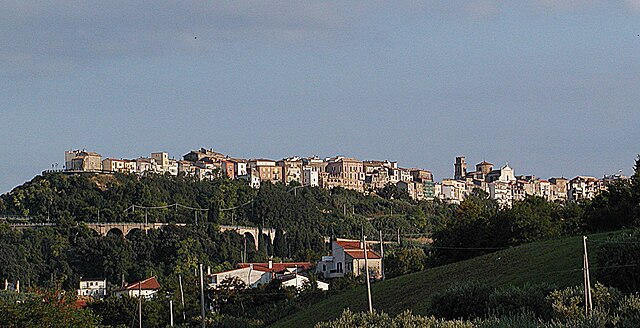
Rocca San Giovanni, located in the Abruzzo region of Italy, is a charming village that sits near the stunning Adriatic coast. It's renowned for its beautiful landscapes, historic architecture, and proximity to the Maiella National Park, making it a great destination for hikers.
Hiking Opportunities:
-
Sentiero della Libertà: This is a well-known trail that commemorates the journey of people escaping during World War II. It offers scenic views of the surrounding countryside and the Adriatic Sea, along with several historical points of interest.
-
Maiella National Park: Just a short distance from Rocca San Giovanni, this park features a variety of trails ranging from easy walks to challenging hikes. The park is home to diverse flora and fauna and offers breathtaking views of rugged mountains and deep valleys.
-
Coastal Trails: The nearby coastline features beautiful paths that allow you to hike along the shore, providing the opportunity to enjoy panoramic views of the sea and the chance to relax on the beach after a hike.
Hiking Tips:
- Preparation: Always check the weather before heading out, and dress in layers since temperatures can vary. Bring enough water and snacks, as well as a basic first aid kit.
- Maps and Guides: It's helpful to have a detailed map or a guidebook. Many local tourism offices provide maps of recommended trails.
- Trail Conditions: Some trails may be rugged or less maintained, so suitable footwear is essential.
Additional Activities:
While in Rocca San Giovanni, consider exploring its historical sites, local cuisine, and vineyards. The area is known for its delicious Abruzzese dishes and wines, making it a wonderful spot to unwind after a day of hiking.
With its mix of natural beauty, culture, and history, Rocca San Giovanni is a fantastic destination for hikers of all levels. Happy hiking!
- Country:

- Postal Code: 66020
- Local Dialing Code: 0872
- Licence Plate Code: CH
- Coordinates: 42° 15' 0" N, 14° 28' 0" E


- GPS tracks (wikiloc): [Link]
- AboveSeaLevel: 150 м m
- Area: 21.7 sq km
- Population: 2333
- Web site: http://www.comuneroccasangiovanni.gov.it/
- Wikipedia en: wiki(en)
- Wikipedia: wiki(it)
- Wikidata storage: Wikidata: Q51275
- Wikipedia Commons Category: [Link]
- Freebase ID: [/m/0fg3jk]
- GeoNames ID: Alt: [6543630]
- VIAF ID: Alt: [146975162]
- OSM relation ID: [41898]
- Library of Congress authority ID: Alt: [no2008186682]
- UN/LOCODE: [ITRSG]
- ISTAT ID: 069074
- Italian cadastre code: H439
Shares border with regions:


Fossacesia
- Italian comune
Hiking in Fossacesia
Fossacesia, located in the Abruzzo region of Italy, offers a wonderful setting for hikers due to its diverse landscapes, ranging from coastal views to hilly terrain. Here are some key points to consider if you're planning to hike in this area:...
- Country:
- Postal Code: 66022
- Local Dialing Code: 0872
- Licence Plate Code: CH
- Coordinates: 42° 15' 0" N, 14° 29' 0" E
- GPS tracks (wikiloc): [Link]
- AboveSeaLevel: 142 м m
- Area: 30.14 sq km
- Population: 6358
- Web site: [Link]

San Vito Chietino
- Italian comune
Hiking in San Vito Chietino
San Vito Chietino, located in the Abruzzo region of Italy, is a charming coastal town known for its beautiful landscapes, historical sites, and access to the stunning Adriatic Sea. Hiking in this area offers a range of experiences, from coastal trails to inland paths that lead through picturesque villages and natural parks. Here are some highlights of hiking in and around San Vito Chietino:...
- Country:
- Postal Code: 66038
- Local Dialing Code: 0872
- Licence Plate Code: CH
- Coordinates: 42° 18' 0" N, 14° 27' 0" E
- GPS tracks (wikiloc): [Link]
- AboveSeaLevel: 122 м m
- Area: 17 sq km
- Population: 5270
- Web site: [Link]
Treglio
- Italian comune
Hiking in Treglio
Treglio is a small town located in the Abruzzo region of Italy, not too far from the Adriatic coast. While Treglio itself may not be a major hiking destination, the surrounding region offers a variety of outdoor activities and breathtaking trails for hikers....
- Country:
- Postal Code: 66030
- Local Dialing Code: 0872
- Licence Plate Code: CH
- Coordinates: 42° 16' 0" N, 14° 25' 0" E
- GPS tracks (wikiloc): [Link]
- AboveSeaLevel: 183 м m
- Area: 4.88 sq km
- Population: 1669
- Web site: [Link]


Lanciano
- Italian comune
Hiking in Lanciano
Lanciano is a charming city in the Abruzzo region of Italy, known for its rich history, beautiful landscapes, and proximity to natural parks, making it a great starting point for hiking enthusiasts....
- Country:
- Postal Code: 66034
- Local Dialing Code: 0872
- Licence Plate Code: CH
- Coordinates: 42° 13' 52" N, 14° 23' 26" E
- GPS tracks (wikiloc): [Link]
- AboveSeaLevel: 265 м m
- Area: 66.94 sq km
- Population: 35002
- Web site: [Link]