Foug (Foug)

- commune in Meurthe-et-Moselle, France
- Country:

- Postal Code: 54570
- Coordinates: 48° 41' 3" N, 5° 47' 11" E


- GPS tracks (wikiloc): [Link]
- Area: 25.49 sq km
- Population: 2713
- Web site: http://www.foug.fr
- Wikipedia en: wiki(en)
- Wikipedia: wiki(fr)
- Wikidata storage: Wikidata: Q1000360
- Wikipedia Commons Category: [Link]
- Freebase ID: [/m/03qdhdh]
- GeoNames ID: Alt: [6454298]
- SIREN number: [215402058]
- BnF ID: [15264274h]
- INSEE municipality code: 54205
Shares border with regions:

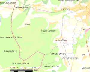
Choloy-Ménillot
- commune in Meurthe-et-Moselle, France
- Country:
- Postal Code: 54200
- Coordinates: 48° 39' 43" N, 5° 49' 9" E
- GPS tracks (wikiloc): [Link]
- AboveSeaLevel: 249 м m
- Area: 11.95 sq km
- Population: 726


Laneuveville-derrière-Foug
- commune in Meurthe-et-Moselle, France
- Country:
- Postal Code: 54570
- Coordinates: 48° 42' 36" N, 5° 48' 16" E
- GPS tracks (wikiloc): [Link]
- AboveSeaLevel: 250 м m
- Area: 1.13 sq km
- Population: 149


Écrouves
- commune in Meurthe-et-Moselle, France
- Country:
- Postal Code: 54200
- Coordinates: 48° 40' 48" N, 5° 50' 26" E
- GPS tracks (wikiloc): [Link]
- Area: 10.3 sq km
- Population: 4389
- Web site: [Link]


Lay-Saint-Remy
- commune in Meurthe-et-Moselle, France
- Country:
- Postal Code: 54570
- Coordinates: 48° 40' 49" N, 5° 45' 45" E
- GPS tracks (wikiloc): [Link]
- AboveSeaLevel: 253 м m
- Area: 3.8 sq km
- Population: 361


Bruley
- commune in Meurthe-et-Moselle, France
- Country:
- Postal Code: 54200
- Coordinates: 48° 42' 26" N, 5° 51' 1" E
- GPS tracks (wikiloc): [Link]
- Area: 6.25 sq km
- Population: 618


Saint-Germain-sur-Meuse
- commune in Meuse, France
- Country:
- Postal Code: 55140
- Coordinates: 48° 38' 59" N, 5° 41' 23" E
- GPS tracks (wikiloc): [Link]
- Area: 7.67 sq km
- Population: 274


Pagny-sur-Meuse
- commune in Meuse, France
- Country:
- Postal Code: 55190
- Coordinates: 48° 41' 15" N, 5° 43' 3" E
- GPS tracks (wikiloc): [Link]
- Area: 18.81 sq km
- Population: 1028

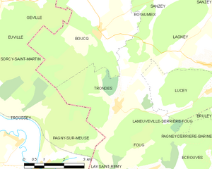
Trondes
- commune in Meurthe-et-Moselle, France
- Country:
- Postal Code: 54570
- Coordinates: 48° 42' 57" N, 5° 46' 21" E
- GPS tracks (wikiloc): [Link]
- Area: 12.64 sq km
- Population: 538


Rigny-la-Salle
- commune in Meuse, France
- Country:
- Postal Code: 55140
- Coordinates: 48° 37' 15" N, 5° 42' 2" E
- GPS tracks (wikiloc): [Link]
- Area: 10.28 sq km
- Population: 379