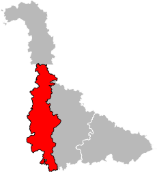
arrondissement of Toul (arrondissement de Toul)
- arrondissement of France
- Country:

- Capital: Toul
- Coordinates: 48° 40' 0" N, 5° 55' 0" E


- GPS tracks (wikiloc): [Link]
- Area: 1509 sq km
- Population: 69523
- Wikipedia en: wiki(en)
- Wikipedia: wiki(fr)
- Wikidata storage: Wikidata: Q702629
- Freebase ID: [/m/09568m]
- GeoNames ID: Alt: [2972349]
- INSEE arrondissement code: [544]
- GNS Unique Feature ID: -1473132
Includes regions:

canton of Colombey-les-Belles
- canton of France
- Country:

- Capital: Colombey-les-Belles
- Coordinates: 48° 28' 40" N, 5° 55' 11" E


- GPS tracks (wikiloc): [Link]

canton of Domèvre-en-Haye
- canton of France
- Country:

- Capital: Domèvre-en-Haye
- Coordinates: 48° 48' 19" N, 5° 55' 28" E


- GPS tracks (wikiloc): [Link]

canton of Thiaucourt-Regniéville
- canton of France
- Country:

- Capital: Thiaucourt-Regniéville
- Coordinates: 48° 55' 39" N, 5° 54' 42" E


- GPS tracks (wikiloc): [Link]
