canton of Toul-Nord (canton de Toul-Nord)
- canton of France
- Country:

- Capital: Toul
- Coordinates: 48° 42' 47" N, 5° 51' 52" E


- GPS tracks (wikiloc): [Link]
- Wikidata storage: Wikidata: Q1727624
- INSEE canton code: [5427]
Includes regions:


Foug
- commune in Meurthe-et-Moselle, France
- Country:
- Postal Code: 54570
- Coordinates: 48° 41' 3" N, 5° 47' 11" E
- GPS tracks (wikiloc): [Link]
- Area: 25.49 sq km
- Population: 2713
- Web site: [Link]


Gondreville
- commune in Meurthe-et-Moselle, France
- Country:
- Postal Code: 54840
- Coordinates: 48° 41' 35" N, 5° 57' 38" E
- GPS tracks (wikiloc): [Link]
- Area: 25.03 sq km
- Population: 2828
Aingeray
- commune in Meurthe-et-Moselle, France
- Country:
- Postal Code: 54460
- Coordinates: 48° 44' 20" N, 6° 0' 6" E
- GPS tracks (wikiloc): [Link]
- Area: 12.79 sq km
- Population: 558


Sanzey
- commune in Meurthe-et-Moselle, France
- Country:
- Postal Code: 54200
- Coordinates: 48° 46' 17" N, 5° 50' 18" E
- GPS tracks (wikiloc): [Link]
- Area: 3.58 sq km
- Population: 131


Laneuveville-derrière-Foug
- commune in Meurthe-et-Moselle, France
- Country:
- Postal Code: 54570
- Coordinates: 48° 42' 36" N, 5° 48' 16" E
- GPS tracks (wikiloc): [Link]
- AboveSeaLevel: 250 м m
- Area: 1.13 sq km
- Population: 149

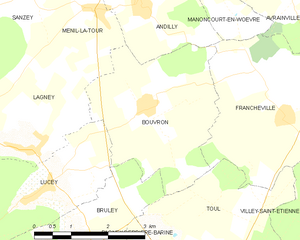
Bouvron
- commune in Meurthe-et-Moselle, France
- Country:
- Postal Code: 54200
- Coordinates: 48° 44' 29" N, 5° 52' 48" E
- GPS tracks (wikiloc): [Link]
- Area: 10 sq km
- Population: 253


Écrouves
- commune in Meurthe-et-Moselle, France
- Country:
- Postal Code: 54200
- Coordinates: 48° 40' 48" N, 5° 50' 26" E
- GPS tracks (wikiloc): [Link]
- Area: 10.3 sq km
- Population: 4389
- Web site: [Link]


Lagney
- commune in Meurthe-et-Moselle, France
- Country:
- Postal Code: 54200
- Coordinates: 48° 43' 59" N, 5° 50' 22" E
- GPS tracks (wikiloc): [Link]
- Area: 14.34 sq km
- Population: 501
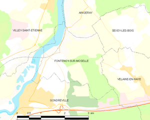
Fontenoy-sur-Moselle
- commune in Meurthe-et-Moselle, France
- Country:
- Postal Code: 54840
- Coordinates: 48° 42' 40" N, 5° 58' 52" E
- GPS tracks (wikiloc): [Link]
- Area: 5.54 sq km
- Population: 371


Lucey
- commune in Meurthe-et-Moselle, France
- Country:
- Postal Code: 54200
- Coordinates: 48° 43' 17" N, 5° 50' 14" E
- GPS tracks (wikiloc): [Link]
- Area: 10.7 sq km
- Population: 615


Pagney-derrière-Barine
- commune in Meurthe-et-Moselle, France
- Country:
- Postal Code: 54200
- Coordinates: 48° 41' 36" N, 5° 50' 37" E
- GPS tracks (wikiloc): [Link]
- Area: 6.13 sq km
- Population: 637


Lay-Saint-Remy
- commune in Meurthe-et-Moselle, France
- Country:
- Postal Code: 54570
- Coordinates: 48° 40' 49" N, 5° 45' 45" E
- GPS tracks (wikiloc): [Link]
- AboveSeaLevel: 253 м m
- Area: 3.8 sq km
- Population: 361


Bruley
- commune in Meurthe-et-Moselle, France
- Country:
- Postal Code: 54200
- Coordinates: 48° 42' 26" N, 5° 51' 1" E
- GPS tracks (wikiloc): [Link]
- Area: 6.25 sq km
- Population: 618


Boucq
- commune in Meurthe-et-Moselle, France
- Country:
- Postal Code: 54200
- Coordinates: 48° 44' 51" N, 5° 45' 44" E
- GPS tracks (wikiloc): [Link]
- Area: 22.66 sq km
- Population: 358


Ménil-la-Tour
- commune in Meurthe-et-Moselle, France
- Country:
- Postal Code: 54200
- Coordinates: 48° 45' 58" N, 5° 51' 48" E
- GPS tracks (wikiloc): [Link]
- Area: 8.82 sq km
- Population: 336


Dommartin-lès-Toul
- commune in Meurthe-et-Moselle, France
- Country:
- Postal Code: 54200
- Coordinates: 48° 40' 12" N, 5° 54' 28" E
- GPS tracks (wikiloc): [Link]
- Area: 6.87 sq km
- Population: 2012

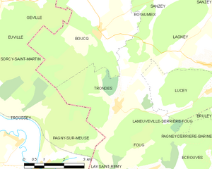
Trondes
- commune in Meurthe-et-Moselle, France
- Country:
- Postal Code: 54570
- Coordinates: 48° 42' 57" N, 5° 46' 21" E
- GPS tracks (wikiloc): [Link]
- Area: 12.64 sq km
- Population: 538