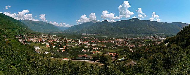
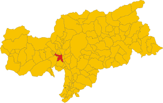
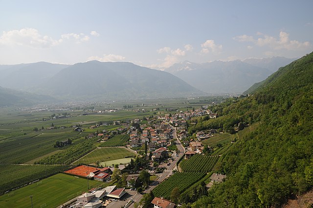
Gargazon (Gargazzone)
.svg)
- Italian comune
 Hiking in Gargazon
Gargazon, located in the South Tyrol region of northern Italy, is a wonderful area for hiking enthusiasts. The region is characterized by its stunning landscapes, which include lush forests, rolling hills, and picturesque views of the surrounding mountains, including the Dolomites. Here are some key points about hiking in Gargazon:
Hiking Trails
-
Variety of Trails: There are numerous marked trails in and around Gargazon suitable for various skill levels, from easy walks to more challenging hikes.
-
Scenic Routes: Popular routes often include paths that lead to panoramic viewpoints, vineyards, and charming villages. The trails are well-maintained and clearly signposted.
-
Character of Trails: You can find trails that pass through diverse terrains, including meadows, forests, and along rivers, providing an immersive experience in nature.
Highlights
-
Historical Sites: Some trails may lead to historical landmarks, such as ancient churches or ruins, offering a cultural twist to your hiking experience.
-
Natural Beauty: The area is rich in flora and fauna, making it a great spot for wildlife watching and photography.
-
Wine Routes: Gargazon is situated in a wine-producing area, and there are trails that incorporate visits to local vineyards, giving hikers the chance to taste the region's famous wines.
Best Time to Hike
- Spring and Fall: The best times for hiking in Gargazon are typically in spring and fall. The weather is generally mild, and the scenery is particularly beautiful with blooming flowers or autumn foliage.
Safety and Preparation
-
Equipment: Depending on the difficulty of your chosen trail, make sure to wear appropriate hiking footwear and gear.
-
Local Regulations: Always check local regulations and trail conditions before heading out. It’s also a good idea to have a map or a hiking app for navigation.
-
Weather Considerations: Be mindful of the weather conditions, as they can change rapidly in mountainous areas.
Additional Tips
-
Guided Tours: If you prefer, consider joining a guided hiking tour to learn more about the area's ecology and history.
-
Local Amenities: Gargazon has accommodations, restaurants, and shops to support your hiking adventure.
Whether you're a novice hiker or an experienced trekker, Gargazon offers a rewarding hiking experience with its blend of natural beauty and cultural richness. Always remember to pack enough water, snacks, and sun protection, and enjoy exploring the trails!
- Country:

- Postal Code: 39010
- Local Dialing Code: 0473
- Licence Plate Code: BZ
- Coordinates: 46° 35' 4" N, 11° 12' 6" E


- GPS tracks (wikiloc): [Link]
- AboveSeaLevel: 267 м m
- Area: 4.91 sq km
- Population: 1688
- Web site: http://www.comune.gargazzone.bz.it
- Wikipedia en: wiki(en)
- Wikipedia: wiki(it)
- Wikidata storage: Wikidata: Q419249
- Wikipedia Commons Gallery: [Link]
- Wikipedia Commons Category: [Link]
- Freebase ID: [/m/0g9gql]
- GeoNames ID: Alt: [6535899]
- VIAF ID: Alt: [144077843]
- OSM relation ID: [47260]
- GND ID: Alt: [10129664-2]
- MusicBrainz area ID: [e9c645d7-fc4e-4d58-a9a5-91fcd044d4de]
- UN/LOCODE: [ITGZE]
- ISTAT ID: 021035
- Italian cadastre code: D923
Shares border with regions:
Lana
- Italian comune in South Tyrol
Hiking in Lana
Lana, located in South Tyrol, Italy, is a fantastic destination for hiking enthusiasts, offering a diverse range of trails set against stunning alpine scenery. Nestled near the larger town of Merano, Lana provides access to beautiful landscapes, charming villages, and cultural sites....
- Country:
- Postal Code: 39011
- Local Dialing Code: 0473
- Licence Plate Code: BZ
- Coordinates: 46° 37' 0" N, 11° 10' 0" E
- GPS tracks (wikiloc): [Link]
- AboveSeaLevel: 310 м m
- Area: 36.12 sq km
- Population: 12286
- Web site: [Link]


Mölten
- Italian comune
Hiking in Mölten
Mölten, or Molten, is a lovely village in South Tyrol, Italy, situated on the sunny side of the Adige Valley. It offers a variety of hiking trails that cater to different experience levels, making it an excellent destination for hikers....
- Country:
- Postal Code: 39010
- Local Dialing Code: 0471
- Licence Plate Code: BZ
- Coordinates: 46° 35' 15" N, 11° 15' 18" E
- GPS tracks (wikiloc): [Link]
- AboveSeaLevel: 1140 м m
- Area: 36.95 sq km
- Population: 1676
- Web site: [Link]


Nals
- Italian comune
Hiking in Nals
Nals, located in South Tyrol, Italy, is a great destination for hiking enthusiasts. Nestled in the picturesque Adige Valley near Bolzano, Nals offers a mix of scenic trails, stunning alpine views, and the unique charm of vineyards and orchards....
- Country:
- Postal Code: 39010
- Local Dialing Code: 0471
- Licence Plate Code: BZ
- Coordinates: 46° 32' 36" N, 11° 12' 22" E
- GPS tracks (wikiloc): [Link]
- AboveSeaLevel: 321 м m
- Area: 12.24 sq km
- Population: 1975
- Web site: [Link]

Burgstall, South Tyrol
- Italian comune
Hiking in Burgstall, South Tyrol
Burgstall is a charming village located in South Tyrol, Italy, known for its picturesque landscapes and proximity to the Alps. Hiking around Burgstall offers a fantastic opportunity to explore the diverse terrain and enjoy stunning views....
- Country:
- Postal Code: 39014
- Local Dialing Code: 0473
- Licence Plate Code: BZ
- Coordinates: 46° 36' 34" N, 11° 11' 35" E
- GPS tracks (wikiloc): [Link]
- AboveSeaLevel: 270 м m
- Area: 6.69 sq km
- Population: 1887
- Web site: [Link]

Terlan
- Italian comune
Hiking in Terlan
Terlan, located in South Tyrol, Italy, is a beautiful destination for hiking enthusiasts. Nestled at the foothills of the Alps and surrounded by vineyards and rolling hills, Terlan offers a variety of trails suitable for all levels, from leisurely walks to challenging mountain hikes....
- Country:
- Postal Code: 39018
- Local Dialing Code: 0471
- Licence Plate Code: BZ
- Coordinates: 46° 31' 56" N, 11° 14' 49" E
- GPS tracks (wikiloc): [Link]
- AboveSeaLevel: 250 м m
- Area: 18.57 sq km
- Population: 4391
- Web site: [Link]


Tisens
- Italian comune
Hiking in Tisens
Tisens, a charming village located in South Tyrol, Italy, is a fantastic destination for hiking enthusiasts. Nestled in the mountains near Merano, it offers a variety of stunning trails that cater to different skill levels. Here’s what you can expect from hiking in Tisens:...
- Country:
- Postal Code: 39010
- Local Dialing Code: 0473
- Licence Plate Code: BZ
- Coordinates: 46° 33' 56" N, 11° 10' 10" E
- GPS tracks (wikiloc): [Link]
- AboveSeaLevel: 635 м m
- Area: 38.13 sq km
- Population: 1979
- Web site: [Link]