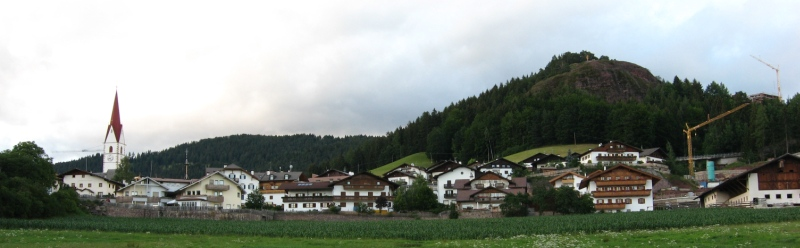
Mölten (Meltina)
.svg)
- Italian comune
 Hiking in Mölten
Mölten, or Molten, is a lovely village in South Tyrol, Italy, situated on the sunny side of the Adige Valley. It offers a variety of hiking trails that cater to different experience levels, making it an excellent destination for hikers.
Key Features of Hiking in Mölten:
-
Scenic Views: The region boasts stunning views of the surrounding mountains, vineyards, and the Adige Valley, especially from higher vantage points along the trails.
-
Trail Variety: There are numerous hiking trails in and around Mölten that range from easy walks to more challenging hikes. Popular trails include routes to the nearby mountains, forests, and meadows.
-
Easy Access: Many trails can be accessed directly from the village. The well-marked paths are suitable for day hikes and allow for exploration of the picturesque landscapes.
-
Cultural Richness: While hiking, you can explore charming villages, traditional farms, and historical sites, providing a glimpse into the local culture and heritage.
-
Seasonal Hiking: Each season offers a different hiking experience – from lush green trails in spring and summer to vibrant autumn foliage and serene winter landscapes for those who enjoy snowshoe hiking.
-
Wildlife and Nature: Hikers often have the chance to observe local wildlife and enjoy the diverse flora along the trails.
-
Local Amenities: Mölten has various cafes and restaurants for refreshments after a hike, allowing hikers to relax and enjoy some local cuisine.
Popular Hiking Routes:
- Hike to the Latzfons Valley: This moderate hike offers fantastic views and connects to more extensive trail networks.
- Peter Mitterhofer Trail: This easier trail is perfect for families and offers educational stops along the way, focusing on the life and work of the famous local inventor.
- Mount Frizzon: For more experienced hikers, the routes to hike up to Mount Frizzon feature more elevation gain but reward you with spectacular panoramas.
Tips for Hiking in Mölten:
- Preparation: Always check the weather conditions and trail status before you set out. Dress in layers and be prepared for changing weather.
- Hydration and Snacks: Carry enough water and snacks to keep your energy up during your hikes.
- Follow Trail Markers: Stick to marked trails to ensure safety and minimize environmental impact.
- Start Early: To make the most of your day and avoid crowds, consider starting your hikes early, especially during peak tourist season.
Whether you're looking for a leisurely walk or a challenging trek, Mölten offers a beautiful hiking experience amidst the stunning backdrop of the South Tyrolean Alps. Happy hiking!
- Country:

- Postal Code: 39010
- Local Dialing Code: 0471
- Licence Plate Code: BZ
- Coordinates: 46° 35' 15" N, 11° 15' 18" E


- GPS tracks (wikiloc): [Link]
- AboveSeaLevel: 1140 м m
- Area: 36.95 sq km
- Population: 1676
- Web site: http://www.gemeinde.moelten.bz.it
- Wikipedia en: wiki(en)
- Wikipedia: wiki(it)
- Wikidata storage: Wikidata: Q428018
- Wikipedia Commons Gallery: [Link]
- Wikipedia Commons Category: [Link]
- Freebase ID: [/m/0g9hfn]
- GeoNames ID: Alt: [6535973]
- VIAF ID: Alt: [134142888]
- OSM relation ID: [47263]
- GND ID: Alt: [4284617-1]
- Library of Congress authority ID: Alt: [nr94028150]
- UN/LOCODE: [ITMT5]
- Digital Atlas of the Roman Empire ID: [17158]
- ISTAT ID: 021050
- Italian cadastre code: F118
Shares border with regions:


Sarntal
- Italian comune
Hiking in Sarntal
Sarntal, also known as the Sarntal Valley, is a beautiful hiking destination located in South Tyrol, Italy, just north of Bolzano. This area is known for its stunning landscapes, diverse flora and fauna, and rich cultural heritage. Here are some key points to consider when planning a hiking trip in Sarntal:...
- Country:
- Postal Code: 39058
- Local Dialing Code: 0471
- Licence Plate Code: BZ
- Coordinates: 46° 38' 37" N, 11° 21' 22" E
- GPS tracks (wikiloc): [Link]
- AboveSeaLevel: 2781 м m
- Area: 302.27 sq km
- Population: 7058
- Web site: [Link]

Vöran
- Italian comune
Hiking in Vöran
Vöran, also known as Verano, is a picturesque village located in the South Tyrol region of northern Italy, nestled in the foothills of the Alps. It is a popular destination for hiking enthusiasts due to its stunning natural landscapes, diverse trails, and mild climate....
- Country:
- Postal Code: 39010
- Local Dialing Code: 0473
- Licence Plate Code: BZ
- Coordinates: 46° 36' 17" N, 11° 13' 35" E
- GPS tracks (wikiloc): [Link]
- AboveSeaLevel: 1204 м m
- Area: 22.01 sq km
- Population: 952
- Web site: [Link]


Gargazon
- Italian comune
Hiking in Gargazon
Gargazon, located in the South Tyrol region of northern Italy, is a wonderful area for hiking enthusiasts. The region is characterized by its stunning landscapes, which include lush forests, rolling hills, and picturesque views of the surrounding mountains, including the Dolomites. Here are some key points about hiking in Gargazon:...
- Country:
- Postal Code: 39010
- Local Dialing Code: 0473
- Licence Plate Code: BZ
- Coordinates: 46° 35' 4" N, 11° 12' 6" E
- GPS tracks (wikiloc): [Link]
- AboveSeaLevel: 267 м m
- Area: 4.91 sq km
- Population: 1688
- Web site: [Link]

Burgstall, South Tyrol
- Italian comune
Hiking in Burgstall, South Tyrol
Burgstall is a charming village located in South Tyrol, Italy, known for its picturesque landscapes and proximity to the Alps. Hiking around Burgstall offers a fantastic opportunity to explore the diverse terrain and enjoy stunning views....
- Country:
- Postal Code: 39014
- Local Dialing Code: 0473
- Licence Plate Code: BZ
- Coordinates: 46° 36' 34" N, 11° 11' 35" E
- GPS tracks (wikiloc): [Link]
- AboveSeaLevel: 270 м m
- Area: 6.69 sq km
- Population: 1887
- Web site: [Link]


Jenesien
- Italian comune
Hiking in Jenesien
Jenesien, or San Genesio in Italian, is a lovely village located on the southern slopes of the Alps, just above the city of Bolzano in South Tyrol, Italy. It's known for its stunning views, rich history, and a plethora of hiking trails that cater to all skill levels. Here are some key highlights and tips if you're considering hiking in Jenesien:...
- Country:
- Postal Code: 39050
- Local Dialing Code: 0471
- Licence Plate Code: BZ
- Coordinates: 46° 32' 5" N, 11° 19' 47" E
- GPS tracks (wikiloc): [Link]
- AboveSeaLevel: 1000 м m
- Area: 68.84 sq km
- Population: 3045
- Web site: [Link]

Terlan
- Italian comune
Hiking in Terlan
Terlan, located in South Tyrol, Italy, is a beautiful destination for hiking enthusiasts. Nestled at the foothills of the Alps and surrounded by vineyards and rolling hills, Terlan offers a variety of trails suitable for all levels, from leisurely walks to challenging mountain hikes....
- Country:
- Postal Code: 39018
- Local Dialing Code: 0471
- Licence Plate Code: BZ
- Coordinates: 46° 31' 56" N, 11° 14' 49" E
- GPS tracks (wikiloc): [Link]
- AboveSeaLevel: 250 м m
- Area: 18.57 sq km
- Population: 4391
- Web site: [Link]