Granges-la-Ville (Granges-la-Ville)

- commune in Haute-Saône, France
- Country:

- Postal Code: 70400
- Coordinates: 47° 34' 0" N, 6° 34' 21" E


- GPS tracks (wikiloc): [Link]
- Area: 2.61 sq km
- Population: 193
- Wikipedia en: wiki(en)
- Wikipedia: wiki(fr)
- Wikidata storage: Wikidata: Q959158
- Wikipedia Commons Category: [Link]
- Freebase ID: [/m/03nvyb0]
- GeoNames ID: Alt: [6441967]
- SIREN number: [217002765]
- BnF ID: [15272668d]
- INSEE municipality code: 70276
Shares border with regions:


Senargent-Mignafans
- commune in Haute-Saône, France
- Country:
- Postal Code: 70110
- Coordinates: 47° 33' 54" N, 6° 31' 34" E
- GPS tracks (wikiloc): [Link]
- AboveSeaLevel: 302 м m
- Area: 10.77 sq km
- Population: 300

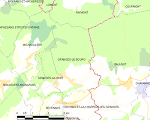
Granges-le-Bourg
- commune in Haute-Saône, France
- Country:
- Postal Code: 70400
- Coordinates: 47° 33' 54" N, 6° 35' 9" E
- GPS tracks (wikiloc): [Link]
- Area: 10.35 sq km
- Population: 383


Mignavillers
- commune in Haute-Saône, France
- Country:
- Postal Code: 70400
- Coordinates: 47° 34' 50" N, 6° 33' 6" E
- GPS tracks (wikiloc): [Link]
- Area: 7.59 sq km
- Population: 337


Secenans
- commune in Haute-Saône, France
 Hiking in Secenans
I’m sorry, but it appears there may be a typo in your query regarding "Secenans." If you meant "Sicily," "Sedona," or another specific hiking destination, please clarify, and I’d be happy to provide information on hiking in that area! If it is a specific local area or trail, please provide more details so I can assist you better....
- Country:
- Postal Code: 70400
- Coordinates: 47° 33' 12" N, 6° 34' 28" E
- GPS tracks (wikiloc): [Link]
- Area: 2.88 sq km
- Population: 176