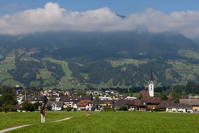
Hasliberg (Hasliberg)

- municipality in the canton of Bern, Switzerland
 Hiking in Hasliberg
Hasliberg is a beautiful region located in the Bernese Oberland of Switzerland, famous for its stunning alpine landscapes and extensive network of hiking trails. Here are some key points to consider when hiking in Hasliberg:
Trails and Terrain
- Varied Difficulty: Hasliberg offers a wide range of trails suitable for all levels—from easy strolls to challenging hikes. This makes it an excellent destination for families, beginners, and experienced hikers alike.
- Scenic Views: Many trails provide breathtaking views of the surrounding mountains, including the Eiger, Mönch, and Jungfrau. The landscape features alpine meadows, forests, and crystal-clear lakes.
- Themed Routes: There are themed trails, such as the “Water Trail,” which showcases the area's water sources and hydraulic engineering, and the “Panorama Trail” for stunning vistas.
Popular Hikes
- Hasliberg – Balisalp: A moderate hike that offers charming views and takes you through idyllic landscapes. Perfect for a day hike.
- Twinger Höhenweg: A scenic high trail providing panoramic views of the surrounding peaks, it's suitable for those looking for an exhilarating experience.
- Mägisalp to Hasliberg Gitschen: This trail offers a mix of terrains, and you can enjoy lovely botanical diversity along the way.
Accessibility
- Cable Cars and Public Transport: Hasliberg is accessible via cable cars, which can take you to higher altitudes, making it easier to access some of the more scenic routes. Public transport options are also available from nearby towns.
Best Time to Hike
- Summer and Early Autumn: The best time to hike in Hasliberg is typically from late June to early October, when the weather is mild and most trails are clear of snow.
Safety and Preparation
- Weather Checks: Always check the weather forecast before you head out, as alpine conditions can change quickly.
- Proper Gear: Wear appropriate hiking shoes and bring enough water, snacks, and a map or GPS device.
- Trail Markers: Follow the marked trails, as they guide you through the safest and most scenic paths.
Additional Activities
- Mountain Biking: In addition to hiking, the Hasliberg region is popular for mountain biking, with numerous trails available.
- Family-Friendly Options: There are playgrounds, picnic areas, and even animal parks for families with children.
Overall, hiking in Hasliberg allows you to connect with nature while enjoying Switzerland's striking beauty. Whether you are looking for a leisurely hike or an adventurous challenge, Hasliberg has something to offer for every enthusiast.
- Country:

- Postal Code: 6085
- Local Dialing Code: 033
- Licence Plate Code: BE
- Coordinates: 46° 44' 47" N, 8° 13' 42" E


- GPS tracks (wikiloc): [Link]
- AboveSeaLevel: 1580 м m
- Area: 41.7 sq km
- Population: 1183
- Web site: http://www.hasliberg.ch
- Wikipedia en: wiki(en)
- Wikipedia: wiki(de)
- Wikidata storage: Wikidata: Q69424
- Wikipedia Commons Category: [Link]
- Wikipedia Commons Maps Category: [Link]
- Freebase ID: [/m/030h49]
- GeoNames ID: Alt: [7286034]
- VIAF ID: Alt: [144922089]
- OSM relation ID: [1682470]
- GND ID: Alt: [4023603-1]
- HDS ID: [469]
- Swiss municipality code: [0783]
Shares border with regions:


Meiringen
- town in the canton of Bern, Switzerland
Hiking in Meiringen
Meiringen, a charming town in the Bernese Oberland region of Switzerland, is an excellent base for hikers looking to explore the stunning landscapes of the Alps. Here are some key points about hiking in Meiringen:...
- Country:
- Postal Code: 3860
- Local Dialing Code: 033
- Licence Plate Code: BE
- Coordinates: 46° 43' 42" N, 8° 11' 10" E
- GPS tracks (wikiloc): [Link]
- AboveSeaLevel: 600 м m
- Area: 40.7 sq km
- Population: 4690
- Web site: [Link]


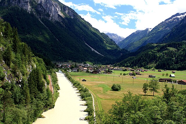
Lungern
- municipality in Switzerland
Hiking in Lungern
Lungern is a beautiful village situated in the Swiss canton of Obwalden, nestled between the spectacular mountains and alongside the pristine Lungern-Turren Lake. The area offers a variety of hiking opportunities that cater to different skill levels, making it an excellent destination for both casual walkers and seasoned hikers. Here are some highlights of hiking in Lungern:...
- Country:
- Postal Code: 6078
- Local Dialing Code: 041
- Licence Plate Code: OW
- Coordinates: 46° 47' 14" N, 8° 9' 35" E
- GPS tracks (wikiloc): [Link]
- AboveSeaLevel: 716 м m
- Area: 46.47 sq km
- Population: 2122
- Web site: [Link]

Kerns
- village in the canton of Obwalden, Switzerland
Hiking in Kerns
Kerns is a picturesque area in Utah, known for its stunning landscapes and outdoor recreation opportunities, including hiking. Here are some key points about hiking in Kerns:...
- Country:
- Postal Code: 6064
- Local Dialing Code: 041
- Licence Plate Code: OW
- Coordinates: 46° 50' 23" N, 8° 18' 5" E
- GPS tracks (wikiloc): [Link]
- AboveSeaLevel: 1017 м m
- Area: 92.58 sq km
- Population: 6295
- Web site: [Link]

Innertkirchen
- village and municipality in the canton of Bern, Switzerland
Hiking in Innertkirchen
Innertkirchen, located in the Bernese Oberland region of Switzerland, is a fantastic destination for hiking enthusiasts. Nestled between the majestic mountains of the Alps, it offers breathtaking landscapes and a variety of trails suitable for different skill levels. Here’s what you can expect when hiking in and around Innertkirchen:...
- Country:
- Postal Code: 3862
- Local Dialing Code: 033
- Licence Plate Code: BE
- Coordinates: 46° 41' 59" N, 8° 14' 0" E
- GPS tracks (wikiloc): [Link]
- AboveSeaLevel: 625 м m
- Area: 120.0 sq km
- Population: 1076
- Web site: [Link]