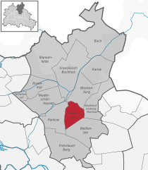
Heinersdorf (Heinersdorf)
- locality of Berlin
Heinersdorf, a charming district on the outskirts of Berlin, offers a unique opportunity for hiking enthusiasts to explore a blend of natural landscapes and quaint, urban settings. While Heinersdorf itself may not have extensive hiking trails like those found in more rugged areas, it serves as an excellent base for accessing nearby natural areas.
Hiking Opportunities in and around Heinersdorf
-
Local Parks and Green Spaces:
- Schweingarten: You can take leisurely walks here, enjoying local flora and possibly spotting wildlife.
- Müggelpark: Close by, this park is ideal for short hikes and picnics, featuring tree-lined paths and open fields.
-
Nearby Forests:
- Wald Siedlung Heinersdorf: Just a short distance away, these wooded areas offer trails suitable for hiking, where you can immerse yourself in nature.
-
Connecting Trails:
- Berliner Mauerweg: This trail follows the route of the former Berlin Wall and offers an interesting blend of history and nature. While it requires some travel from Heinersdorf, it provides a longer hiking experience with various access points.
- Spree Forest Trails: A bit farther afield, the Spree Forest is renowned for its picturesque waterways and is a fantastic destination for more demanding hikes.
-
Accessible Public Transport:
- Heinersdorf is well-connected by public transport, making it easy to reach various hiking spots outside the district. The S-Bahn and bus services can take you to places like the Tegel Forest or the Grünau area along the Dahme River.
Tips for Hiking in Heinersdorf
- Check the Weather: Berlin's weather can be unpredictable, so ensure you're prepared for sudden changes.
- Stay Hydrated and Nourished: Bring enough water and snacks, especially if you plan to hike for several hours.
- Proper Footwear: Wear comfortable, sturdy shoes suitable for walking and varying terrain.
- Navigation: A map or hiking app can be useful to navigate the trails and explore nearby areas effectively.
- Respect Nature: Follow Leave No Trace principles to keep the local environment pristine for future hikers.
Whether you're looking for a quick nature escape or planning a longer hike into the surrounding areas, Heinersdorf provides a great starting point for your outdoor adventures!
- Country:

- Coordinates: 52° 34' 1" N, 13° 26' 24" E


- GPS tracks (wikiloc): [Link]
- AboveSeaLevel: 50 м m
- Area: 3.95 sq km
- Wikipedia en: wiki(en)
- Wikipedia: wiki(de)
- Wikidata storage: Wikidata: Q693540
- Wikipedia Commons Gallery: [Link]
- Wikipedia Commons Category: [Link]
- Freebase ID: [/m/04g0ysy]
- GeoNames ID: Alt: [2907298]
- VIAF ID: Alt: [133242130]
- OSM relation ID: [409202]
Shares border with regions:


Pankow
- locality of the borough Pankow of Berlin
Pankow is a district in northeastern Berlin, Germany, known for its charming neighborhoods, parks, and green areas. While it is more urban compared to rural hiking destinations, there are still opportunities for enjoyable walks and hikes within and around the area....
- Country:

- Coordinates: 52° 34' 0" N, 13° 24' 0" E


- GPS tracks (wikiloc): [Link]
- AboveSeaLevel: 47 м m
- Area: 5.66 sq km
- Population: 57113


Stadtrandsiedlung Malchow
- locality of Berlin
 Hiking in Stadtrandsiedlung Malchow
Stadtrandsiedlung Malchow is a charming area located in the outskirts of Berlin, characterized by its natural beauty and access to various outdoor activities, including hiking. Here’s a breakdown of what you can expect when hiking in this area:...
- Country:

- Coordinates: 52° 34' 20" N, 13° 28' 0" E


- GPS tracks (wikiloc): [Link]
- AboveSeaLevel: 47 м m
- Area: 5.68 sq km


Weissensee
- locality of Berlin
Weissensee is a district in the northeastern part of Berlin, known for its large lake, Weissensee, which is a popular destination for both locals and tourists looking to enjoy nature and outdoor activities. While Weissensee is not traditionally associated with extensive hiking trails like some of the larger natural parks or forested areas, it offers some lovely spots for walking and enjoying the outdoors....
- Country:

- Coordinates: 52° 33' 0" N, 13° 28' 0" E


- GPS tracks (wikiloc): [Link]
- AboveSeaLevel: 53 м m
- Area: 7.93 sq km
- Population: 51699
- Web site: [Link]
Blankenburg
- locality of Berlin
Blankenburg, a district in the northeastern part of Berlin, is not typically known for traditional hiking trails like those found in more mountainous or rural areas. However, it still offers opportunities for outdoor exploration and walking in a more urban and suburban environment. Here are some highlights and suggestions for enjoying the area:...
- Country:

- Coordinates: 52° 35' 35" N, 13° 27' 15" E


- GPS tracks (wikiloc): [Link]
- AboveSeaLevel: 47 м m
- Area: 6.03 sq km
- Population: 6536
