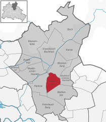
Stadtrandsiedlung Malchow (Stadtrandsiedlung Malchow)

- locality of Berlin
 Hiking in Stadtrandsiedlung Malchow
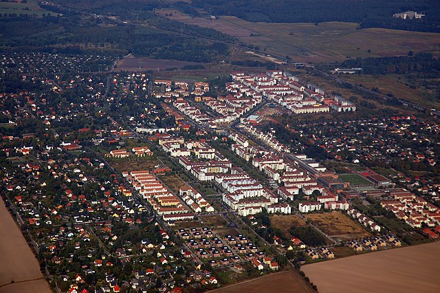
Stadtrandsiedlung Malchow is a charming area located in the outskirts of Berlin, characterized by its natural beauty and access to various outdoor activities, including hiking. Here’s a breakdown of what you can expect when hiking in this area:
Trail Options
-
Local Parks and Green Spaces: The area is surrounded by parks, forested areas, and natural reserves. The nearby Malchow Lake and Landschaftspark Malchow provide scenic trails and opportunities to enjoy the natural surroundings.
-
Nature Walks: You can explore trails around the lake that offer picturesque views and a chance to observe local wildlife. The area is suitable for both leisurely strolls and moderate hikes.
-
Adjacent Hiking Areas: If you’re looking for longer hikes or more challenging terrain, consider venturing to nearby larger parks like Klausgarten or Müggelwald, which are accessible and have extensive trail networks.
Tips for Hiking in Stadtrandsiedlung Malchow
- Footwear: Wear sturdy and comfortable hiking shoes, as some trails can be uneven or muddy.
- Stay Hydrated: Bring enough water, especially if you plan on hiking for several hours.
- Weather Consideration: Check the weather forecast before heading out and dress in layers, as conditions can change.
- Trail Maps: It’s helpful to have a map or a smartphone app with trail information to guide your hike.
- Respect Nature: Stay on marked trails, avoid littering, and leave wildlife undisturbed.
Accessibility
Stadtrandsiedlung Malchow is easily accessible from central Berlin by public transport. This makes it a convenient destination for a quick escape into nature without straying too far from the city.
Conclusion
Hiking in Stadtrandsiedlung Malchow offers a wonderful opportunity to connect with nature while experiencing the tranquility of the outskirts of Berlin. Whether you are a beginner or an experienced hiker, there are options available to match your preferences. Enjoy your hike!
- Country:

- Coordinates: 52° 34' 20" N, 13° 28' 0" E


- GPS tracks (wikiloc): [Link]
- AboveSeaLevel: 47 м m
- Area: 5.68 sq km
- Wikipedia en: wiki(en)
- Wikipedia: wiki(de)
- Wikidata storage: Wikidata: Q644396
- Wikipedia Commons Category: [Link]
- Wikipedia Commons Maps Category: [Link]
- Freebase ID: [/m/0bs3sd6]
- GeoNames ID: Alt: [8334619]
- archINFORM location ID: [43342]
Shares border with regions:


Wartenberg
- locality of Berlin
Hiking in Wartenberg
Wartenberg is a district located in the northeastern part of Berlin, known for its more residential and green areas compared to the bustling city center. While it may not be a well-known hiking destination like some national parks or renowned trails, there are still several opportunities for outdoor activity and exploration in and around Wartenberg....
- Country:
- Coordinates: 52° 34' 45" N, 13° 31' 15" E
- GPS tracks (wikiloc): [Link]
- AboveSeaLevel: 58 м m
- Area: 6.92 sq km


Malchow
- locality of Berlin
Hiking in Malchow
Malchow is a district in the northeastern part of Berlin, situated at the confluence of the Malchower See and the Wuhle River. While it may not be a traditional hiking hotspot like national parks or mountainous regions, it offers some lovely opportunities for walking and enjoying nature, especially along its waterways and parks....
- Country:
- Coordinates: 52° 34' 45" N, 13° 29' 0" E
- GPS tracks (wikiloc): [Link]
- AboveSeaLevel: 57 м m
- Area: 1.54 sq km
- Population: 508


Neu-Hohenschönhausen
- locality of Berlin
Hiking in Neu-Hohenschönhausen
Neu-Hohenschönhausen is a district located in the northeastern part of Berlin, Germany. While it is primarily an urban area known for its residential neighborhoods, parks, and recreational spaces, there are still opportunities for hiking and enjoying nature nearby, particularly in green spaces and surrounding areas....
- Country:
- Coordinates: 52° 33' 48" N, 13° 30' 18" E
- GPS tracks (wikiloc): [Link]
- AboveSeaLevel: 55 м m
- Area: 5.16 sq km
- Population: 53374


Weissensee
- locality of Berlin
Hiking in Weissensee
Weissensee is a district in the northeastern part of Berlin, known for its large lake, Weissensee, which is a popular destination for both locals and tourists looking to enjoy nature and outdoor activities. While Weissensee is not traditionally associated with extensive hiking trails like some of the larger natural parks or forested areas, it offers some lovely spots for walking and enjoying the outdoors....
- Country:
- Coordinates: 52° 33' 0" N, 13° 28' 0" E
- GPS tracks (wikiloc): [Link]
- AboveSeaLevel: 53 м m
- Area: 7.93 sq km
- Population: 51699
- Web site: [Link]

Heinersdorf
- locality of Berlin
Hiking in Heinersdorf
Heinersdorf, a charming district on the outskirts of Berlin, offers a unique opportunity for hiking enthusiasts to explore a blend of natural landscapes and quaint, urban settings. While Heinersdorf itself may not have extensive hiking trails like those found in more rugged areas, it serves as an excellent base for accessing nearby natural areas....
- Country:
- Coordinates: 52° 34' 1" N, 13° 26' 24" E
- GPS tracks (wikiloc): [Link]
- AboveSeaLevel: 50 м m
- Area: 3.95 sq km
Blankenburg
- locality of Berlin
Hiking in Blankenburg
Blankenburg, a district in the northeastern part of Berlin, is not typically known for traditional hiking trails like those found in more mountainous or rural areas. However, it still offers opportunities for outdoor exploration and walking in a more urban and suburban environment. Here are some highlights and suggestions for enjoying the area:...
- Country:
- Coordinates: 52° 35' 35" N, 13° 27' 15" E
- GPS tracks (wikiloc): [Link]
- AboveSeaLevel: 47 м m
- Area: 6.03 sq km
- Population: 6536

Karow
- locality of Berlin
Hiking in Karow
Karow, located in the northeastern part of Berlin, is primarily a residential district, but it offers some opportunities for nature walks and light hiking. While it may not be a primary destination for serious hikers, there are several parks and green spaces nearby that can make for pleasant outdoor activities....
- Country:
- Coordinates: 52° 36' 45" N, 13° 29' 0" E
- GPS tracks (wikiloc): [Link]
- AboveSeaLevel: 55 м m
- Area: 6.65 sq km