Hudiviller (Hudiviller)

- commune in Meurthe-et-Moselle, France
- Country:

- Postal Code: 54110
- Coordinates: 48° 36' 9" N, 6° 23' 44" E


- GPS tracks (wikiloc): [Link]
- Area: 2.99 sq km
- Population: 342
- Wikipedia en: wiki(en)
- Wikipedia: wiki(fr)
- Wikidata storage: Wikidata: Q379140
- Wikipedia Commons Category: [Link]
- Freebase ID: [/m/03qdj79]
- Freebase ID: [/m/03qdj79]
- GeoNames ID: Alt: [6436668]
- GeoNames ID: Alt: [6436668]
- SIREN number: [215402694]
- SIREN number: [215402694]
- BnF ID: [15264338x]
- BnF ID: [15264338x]
- INSEE municipality code: 54269
- INSEE municipality code: 54269
Shares border with regions:


Anthelupt
- commune in Meurthe-et-Moselle, France
- Country:
- Postal Code: 54110
- Coordinates: 48° 36' 35" N, 6° 24' 50" E
- GPS tracks (wikiloc): [Link]
- Area: 7.82 sq km
- Population: 455


Rosières-aux-Salines
- commune in Meurthe-et-Moselle, France
- Country:
- Postal Code: 54110
- Coordinates: 48° 35' 32" N, 6° 20' 0" E
- GPS tracks (wikiloc): [Link]
- Area: 26.95 sq km
- Population: 2865
- Web site: [Link]
Flainval
- commune in Meurthe-et-Moselle, France
- Country:
- Postal Code: 54110
- Coordinates: 48° 37' 8" N, 6° 23' 56" E
- GPS tracks (wikiloc): [Link]
- Area: 3.61 sq km
- Population: 201

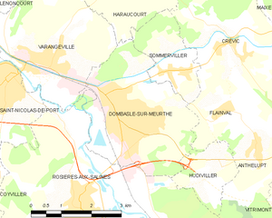
Dombasle-sur-Meurthe
- commune in Meurthe-et-Moselle, France
- Country:
- Postal Code: 54110
- Coordinates: 48° 37' 30" N, 6° 20' 59" E
- GPS tracks (wikiloc): [Link]
- Area: 11.21 sq km
- Population: 9828
- Web site: [Link]