canton of Lunéville-Nord (canton de Lunéville-Nord)
- canton of France (until March 2015)
- Country:

- Capital: Lunéville
- Coordinates: 48° 38' 40" N, 6° 26' 58" E


- GPS tracks (wikiloc): [Link]
- Wikidata storage: Wikidata: Q250573
- INSEE canton code: [5417]
Includes regions:


Bauzemont
- commune in Meurthe-et-Moselle, France
- Country:
- Postal Code: 54370
- Coordinates: 48° 40' 22" N, 6° 31' 40" E
- GPS tracks (wikiloc): [Link]
- Area: 6.32 sq km
- Population: 149


Anthelupt
- commune in Meurthe-et-Moselle, France
- Country:
- Postal Code: 54110
- Coordinates: 48° 36' 35" N, 6° 24' 50" E
- GPS tracks (wikiloc): [Link]
- Area: 7.82 sq km
- Population: 455


Vitrimont
- commune in Meurthe-et-Moselle, France
- Country:
- Postal Code: 54300
- Coordinates: 48° 36' 3" N, 6° 26' 23" E
- GPS tracks (wikiloc): [Link]
- Area: 11.85 sq km
- Population: 403


Sommerviller
- commune in Meurthe-et-Moselle, France
- Country:
- Postal Code: 54110
- Coordinates: 48° 37' 55" N, 6° 22' 35" E
- GPS tracks (wikiloc): [Link]
- Area: 3.81 sq km
- Population: 980


Hoéville
- commune in Meurthe-et-Moselle, France
- Country:
- Postal Code: 54370
- Coordinates: 48° 42' 25" N, 6° 26' 5" E
- GPS tracks (wikiloc): [Link]
- Area: 8.54 sq km
- Population: 197


Maixe
- commune in Meurthe-et-Moselle, France
- Country:
- Postal Code: 54370
- Coordinates: 48° 38' 42" N, 6° 26' 22" E
- GPS tracks (wikiloc): [Link]
- Area: 9.33 sq km
- Population: 412
Flainval
- commune in Meurthe-et-Moselle, France
- Country:
- Postal Code: 54110
- Coordinates: 48° 37' 8" N, 6° 23' 56" E
- GPS tracks (wikiloc): [Link]
- Area: 3.61 sq km
- Population: 201


Serres
- commune in Meurthe-et-Moselle, France
- Country:
- Postal Code: 54370
- Coordinates: 48° 41' 24" N, 6° 27' 45" E
- GPS tracks (wikiloc): [Link]
- Area: 15.55 sq km
- Population: 241


Drouville
- commune in Meurthe-et-Moselle, France
- Country:
- Postal Code: 54370
- Coordinates: 48° 40' 16" N, 6° 24' 29" E
- GPS tracks (wikiloc): [Link]
- Area: 7.12 sq km
- Population: 202


Einville-au-Jard
- commune in Meurthe-et-Moselle, France
- Country:
- Postal Code: 54370
- Coordinates: 48° 39' 18" N, 6° 29' 14" E
- GPS tracks (wikiloc): [Link]
- Area: 16.98 sq km
- Population: 1218
- Web site: [Link]

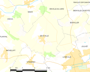
Deuxville
- commune in Meurthe-et-Moselle, France
- Country:
- Postal Code: 54370
- Coordinates: 48° 37' 4" N, 6° 27' 18" E
- GPS tracks (wikiloc): [Link]
- Area: 7.23 sq km
- Population: 427


Hudiviller
- commune in Meurthe-et-Moselle, France
- Country:
- Postal Code: 54110
- Coordinates: 48° 36' 9" N, 6° 23' 44" E
- GPS tracks (wikiloc): [Link]
- Area: 2.99 sq km
- Population: 342


Crévic
- commune in Meurthe-et-Moselle, France
- Country:
- Postal Code: 54110
- Coordinates: 48° 38' 20" N, 6° 24' 14" E
- GPS tracks (wikiloc): [Link]
- Area: 10.69 sq km
- Population: 889

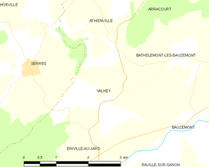
Valhey
- commune in Meurthe-et-Moselle, France
- Country:
- Postal Code: 54370
- Coordinates: 48° 40' 46" N, 6° 29' 29" E
- GPS tracks (wikiloc): [Link]
- Area: 6.23 sq km
- Population: 177


Courbesseaux
- commune in Meurthe-et-Moselle, France
- Country:
- Postal Code: 54110
- Coordinates: 48° 41' 22" N, 6° 23' 46" E
- GPS tracks (wikiloc): [Link]
- Area: 6.32 sq km
- Population: 323
- Web site: [Link]


Raville-sur-Sânon
- commune in Meurthe-et-Moselle, France
- Country:
- Postal Code: 54370
- Coordinates: 48° 39' 3" N, 6° 29' 51" E
- GPS tracks (wikiloc): [Link]
- Area: 3.35 sq km
- Population: 103


Bienville-la-Petite
- commune in Meurthe-et-Moselle, France
- Country:
- Postal Code: 54300
- Coordinates: 48° 38' 17" N, 6° 30' 32" E
- GPS tracks (wikiloc): [Link]
- Area: 1.83 sq km
- Population: 33


Bonviller
- commune in Meurthe-et-Moselle, France
- Country:
- Postal Code: 54300
- Coordinates: 48° 38' 1" N, 6° 29' 50" E
- GPS tracks (wikiloc): [Link]
- Area: 5.04 sq km
- Population: 186