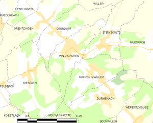
Illtal (Illtal)
- commune in Haut-Rhin, France
Illtal, located in the Alsace region of France near the border with Germany, is known for its picturesque landscapes, charming villages, and diverse hiking trails. Here are some highlights and tips for hiking in the Illtal area:
Trails
-
Ill Valley Trail (Sentier du Val d'Ill): This is a popular trail that takes you through lush forests and along the Ill River. The trail is well-marked and offers beautiful views, making it suitable for hikers of all levels.
-
Local Nature Reserves: Several nature reserves in the region are ideal for hiking, such as the Parc Naturel Régional des Ballons des Vosges. Here, you can explore mountainous terrains, valleys, and varied ecosystems.
-
Wine Trails: The Alsace Wine Route features numerous trails that wind through vineyards and small wine-producing villages. These trails often combine hiking with wine tasting, allowing you to enjoy the local culture and cuisine.
Tips for Hiking in Illtal
- Trail Maps: Before heading out, it's a good idea to obtain a trail map or use a reliable hiking app, as some paths may not be well signposted.
- Weather Considerations: The weather can change quickly in the region, so check the forecast and plan accordingly. Dressing in layers is essential.
- Hydration and Snacks: Always carry enough water and snacks, especially if you plan on hiking longer trails or at higher elevations.
- Wildlife Awareness: While hiking, be aware of local wildlife, and follow guidelines for observing animals without disturbing them.
- Respect Nature: Practice Leave No Trace principles to preserve the natural beauty of the area.
Best Times to Hike
- Spring (April to June) and Fall (September to October) are ideal for hiking due to mild temperatures and stunning scenery, with flowers blooming in spring and vibrant foliage in fall.
- Summer may be hot, and many trails can become crowded, while winter hiking can be beautiful but requires special gear due to snow and ice.
Illtal offers a wonderful blend of natural beauty and cultural experiences, making it a fantastic destination for hiking enthusiasts. Enjoy your adventure!
- Country:

- Postal Code: 68960
- Licence Plate Code: 68
- Coordinates: 47° 33' 34" N, 7° 18' 29" E


- GPS tracks (wikiloc): [Link]
- Area: 11.96 sq km
- Wikipedia en: wiki(en)
- Wikipedia: wiki(fr)
- Wikidata storage: Wikidata: Q21667158
- Wikipedia Commons Category: [Link]
- SIREN number: [200058717]
- OpenCorporates ID: [fr/200058717]
- INSEE municipality code: 68240
Shares border with regions:


Riespach
- commune in Haut-Rhin, France
Riespach is a small region in the Vosges mountains of France, known for its picturesque landscapes and outdoor activities, including hiking. Here are some key points to consider if you plan to hike in Riespach:...
- Country:

- Postal Code: 68640
- Coordinates: 47° 32' 26" N, 7° 17' 15" E


- GPS tracks (wikiloc): [Link]
- Area: 7.57 sq km
- Population: 686


Grentzingen
- former commune in Haut-Rhin, France
Grentzingen is a small village located in the Alsace region of France, near the border with Germany. While Grentzingen itself may not be the most famous hiking destination, its proximity to the Vosges mountains and the beautiful Alsace countryside offers some excellent hiking opportunities....
- Country:

- Postal Code: 68960
- Coordinates: 47° 33' 55" N, 7° 17' 56" E


- GPS tracks (wikiloc): [Link]
- Area: 5.18 sq km
- Population: 568


Waldighofen
- commune in Haut-Rhin, France
Waldighofen is a charming village located in the Alsace region of France, known for its picturesque landscapes and outdoor activities, including hiking. When hiking in Waldighofen, you can expect scenic views, a mix of forests, fields, and vineyards, as well as a mild climate suitable for year-round exploration....
- Country:

- Postal Code: 68640
- Coordinates: 47° 33' 3" N, 7° 19' 0" E


- GPS tracks (wikiloc): [Link]
- Area: 4.14 sq km
- Population: 1544
- Web site: [Link]


Willer
- commune in Haut-Rhin, France
Willer, a small community nestled in a scenic area, offers a variety of hiking opportunities that cater to different skill levels. While specific trails and conditions may vary, here are some key points to consider for hiking in or around Willer:...
- Country:

- Postal Code: 68960
- Coordinates: 47° 35' 9" N, 7° 19' 11" E


- GPS tracks (wikiloc): [Link]
- Area: 6.21 sq km
- Population: 324


Steinsoultz
- commune in Haut-Rhin, France
Steinsoultz, located in the Alsace region of France near the Vosges mountains, offers a picturesque setting for hiking enthusiasts. The region is known for its stunning landscapes, charming villages, and diverse trails that cater to various skill levels....
- Country:

- Postal Code: 68640
- Coordinates: 47° 33' 14" N, 7° 20' 15" E


- GPS tracks (wikiloc): [Link]
- Area: 4.06 sq km
- Population: 788

