Kiens (Chienes)
.svg)
- Italian comune
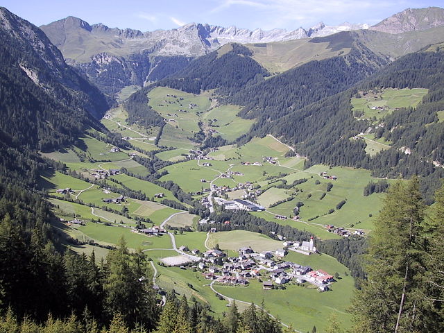
 Hiking in Kiens
Kiens, located in South Tyrol, Italy, is a beautiful destination for hiking enthusiasts. The area is characterized by stunning mountain scenery, lush valleys, and a variety of trails that cater to different skill levels. Here are some highlights of hiking in Kiens:
Trail Variety
- Easy Trails: There are several easy hiking paths suitable for families and beginners. These trails often lead through picturesque villages and farmland, offering beautiful views of the surrounding mountains.
- Moderate Trails: For those looking for a bit more challenge, there are moderate hikes that may ascend to higher altitudes or lead to scenic viewpoints, providing rewards such as panoramic vistas.
- Difficult Trails: Experienced hikers can find challenging routes that include steeper climbs and more rugged terrain, often leading to breathtaking summits and less-traveled paths.
Scenic Views
Hiking in Kiens offers stunning views of the Dolomites, lush green hills, and the Puster Valley. Some trails may also pass by historical sites, such as old castles, quaint churches, or traditional farms.
Nature and Wildlife
The area is rich in biodiversity, making it a great spot for nature lovers. Hikers might encounter various types of flora and fauna, including unique alpine plants and local wildlife such as deer, chamois, and a variety of bird species.
Local Culture
While hiking, you may also experience the local culture. Small villages and rustic huts often serve traditional Tyrolean cuisine, allowing you to enjoy regional specialties and refresh during your hike.
Best Time to Hike
The best time for hiking in Kiens usually spans from late spring through early autumn (May to October), when the weather is generally mild and the trails are mostly clear of snow.
Hiking Tips
- Start Early: Begin your hikes early in the day to take advantage of cooler temperatures and to have more time to enjoy the scenery.
- Stay Hydrated: Bring plenty of water, especially on warmer days, and consider packing snacks for energy.
- Wear Appropriate Gear: Good hiking boots and weather-appropriate clothing are essential, as conditions can change rapidly in the mountains.
- Use Maps or Guides: Consider using a trail map or a hiking app to navigate and ensure you're on the right path.
With its breathtaking landscapes and diverse trails, Kiens is a fantastic destination for anyone looking to explore the beauty of the Italian Alps on foot. Enjoy your hiking adventure!
- Country:

- Postal Code: 39030
- Local Dialing Code: 0474
- Licence Plate Code: BZ
- Coordinates: 46° 48' 24" N, 11° 50' 24" E


- GPS tracks (wikiloc): [Link]
- AboveSeaLevel: 784 м m
- Area: 33.68 sq km
- Population: 2838
- Web site: http://www.comune.chienes.bz.it/system/web/default.aspx?sprache=3
- Wikipedia en: wiki(en)
- Wikipedia: wiki(it)
- Wikidata storage: Wikidata: Q377751
- Wikipedia Commons Gallery: [Link]
- Wikipedia Commons Category: [Link]
- Freebase ID: [/m/0g9gd_]
- GeoNames ID: Alt: [6535892]
- VIAF ID: Alt: [168151309]
- OSM relation ID: [47324]
- GND ID: Alt: [4030496-6]
- Library of Congress authority ID: Alt: [n85380159]
- MusicBrainz area ID: [19c31119-120a-49f8-8e0e-bb29150b01fa]
- UN/LOCODE: [ITCH8]
- ISTAT ID: 021021
- Italian cadastre code: C625
Shares border with regions:

Vintl
- Italian comune
Hiking in Vintl
Vintl, or Vintl in German, is a scenic village located in South Tyrol, northern Italy. It's an excellent base for hiking enthusiasts, as the surrounding area offers a variety of trails ranging from easy strolls to challenging mountain hikes....
- Country:
- Postal Code: 39030
- Local Dialing Code: 0472
- Licence Plate Code: BZ
- Coordinates: 46° 48' 54" N, 11° 43' 14" E
- GPS tracks (wikiloc): [Link]
- AboveSeaLevel: 755 м m
- Area: 110.82 sq km
- Population: 3336
- Web site: [Link]
Pfalzen
- Italian comune
Hiking in Pfalzen
Pfalzen, also known as Falzes, is a charming village located in South Tyrol, Italy, nestled in the stunning Dolomites region. It offers a variety of hiking opportunities for all levels of hikers, with beautiful landscapes, scenic views, and a rich natural environment....
- Country:
- Postal Code: 39030
- Local Dialing Code: 0474
- Licence Plate Code: BZ
- Coordinates: 46° 48' 49" N, 11° 52' 59" E
- GPS tracks (wikiloc): [Link]
- AboveSeaLevel: 1022 м m
- Area: 33.13 sq km
- Population: 2783
- Web site: [Link]


Rodeneck
- Italian comune
Hiking in Rodeneck
Rodeneck (or Rodengo) is a charming village in South Tyrol, Italy, located near Bressanone/Brixen. It's an excellent destination for hiking enthusiasts, offering a variety of trails that cater to different skill levels, from leisurely walks to more challenging hikes....
- Country:
- Postal Code: 39037
- Local Dialing Code: 0472
- Licence Plate Code: BZ
- Coordinates: 46° 47' 0" N, 11° 41' 0" E
- GPS tracks (wikiloc): [Link]
- AboveSeaLevel: 885 м m
- Area: 29.62 sq km
- Population: 1230
- Web site: [Link]


Terenten
- Italian comune
Hiking in Terenten
Terenten, a picturesque village located in the South Tyrol region of northern Italy, offers stunning landscapes, fresh air, and a variety of hiking trails suitable for all levels of experience. Here are some key points about hiking in Terenten:...
- Country:
- Postal Code: 39030
- Local Dialing Code: 0472
- Licence Plate Code: BZ
- Coordinates: 46° 49' 48" N, 11° 46' 58" E
- GPS tracks (wikiloc): [Link]
- AboveSeaLevel: 1210 м m
- Area: 42.16 sq km
- Population: 1753
- Web site: [Link]


St. Lorenzen
- Italian comune
Hiking in St. Lorenzen
St. Lorenzen, located in the picturesque region of South Tyrol in northern Italy, offers a variety of hiking opportunities suitable for all skill levels. The area is known for its stunning natural landscapes, including mountains, forests, and charming meadows, making it an excellent destination for outdoor enthusiasts....
- Country:
- Postal Code: 39030
- Local Dialing Code: 0474
- Licence Plate Code: BZ
- Coordinates: 46° 47' 7" N, 11° 54' 29" E
- GPS tracks (wikiloc): [Link]
- AboveSeaLevel: 810 м m
- Area: 51.46 sq km
- Population: 3889
- Web site: [Link]

Mühlwald
- Italian comune
Hiking in Mühlwald
Mühlwald, located in South Tyrol, Italy, offers beautiful hiking opportunities set against a stunning backdrop of the Eastern Alps. The region is known for its lush landscapes, diverse flora and fauna, and well-marked trails that cater to various skill levels, from easy walks to challenging mountain hikes. Here are some highlights of hiking in Mühlwald:...
- Country:
- Postal Code: 39030
- Local Dialing Code: 0474
- Licence Plate Code: BZ
- Coordinates: 46° 53' 25" N, 11° 51' 30" E
- GPS tracks (wikiloc): [Link]
- AboveSeaLevel: 1229 м m
- Area: 104.79 sq km
- Population: 1437
- Web site: [Link]