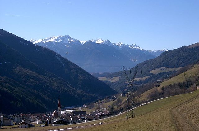
St. Lorenzen (San Lorenzo di Sebato)
.svg)
- Italian comune
 Hiking in St. Lorenzen
St. Lorenzen, located in the picturesque region of South Tyrol in northern Italy, offers a variety of hiking opportunities suitable for all skill levels. The area is known for its stunning natural landscapes, including mountains, forests, and charming meadows, making it an excellent destination for outdoor enthusiasts.
Hiking Highlights in St. Lorenzen:
-
Diverse Trails:
- St. Lorenzen has numerous marked hiking trails ranging from easy walks to more challenging hikes. You can find routes that go through lush forests, along rivers, and up to mountain peaks.
-
Natural Reserves:
- The area is close to natural reserves and parks, such as the Fanes-Senes-Braies Nature Park. This park features breathtaking panoramas and is home to a variety of flora and fauna.
-
Scenic Views:
- Many hiking trails offer panoramic views of the Dolomites, a UNESCO World Heritage site. Some popular viewpoints include the Plan de Corones and the Monte Cavallo.
-
Cultural Experience:
- As you hike, you'll encounter traditional South Tyrolean architecture, quaint villages, and local mountain huts (called "Hütten") where you can enjoy authentic regional cuisine.
-
Seasonal Activities:
- Depending on the season, hiking can involve different experiences. In summer, enjoy lush greenery and blooming wildflowers, while in autumn, witness stunning foliage.
Essential Tips for Hiking in St. Lorenzen:
- Map and Trail Information: Always carry a map and consult local trail guides or visitor centers to understand trail conditions and weather forecasts.
- Proper Gear: Wear sturdy hiking boots and bring layers to accommodate changing temperatures. A good backpack with water, snacks, and a first-aid kit is essential.
- Respect Nature: Follow the leave-no-trace principles to keep the trails beautiful and protect local wildlife.
- Start Early: Especially in summer, starting your hike early can help you avoid the heat of the day and give you time to enjoy your surroundings.
Hiking in St. Lorenzen is not just about the physical activity; it’s an opportunity to connect with nature and experience the unique culture of the South Tyrol region. Enjoy your hike!
- Country:

- Postal Code: 39030
- Local Dialing Code: 0474
- Licence Plate Code: BZ
- Coordinates: 46° 47' 7" N, 11° 54' 29" E


- GPS tracks (wikiloc): [Link]
- AboveSeaLevel: 810 м m
- Area: 51.46 sq km
- Population: 3889
- Web site: http://www.comune.sanlorenzoinbanale.tn.it
- Wikipedia en: wiki(en)
- Wikipedia: wiki(it)
- Wikidata storage: Wikidata: Q504178
- Wikipedia Commons Gallery: [Link]
- Wikipedia Commons Category: [Link]
- Freebase ID: [/m/0g9jqs]
- GeoNames ID: Alt: [6535926]
- BnF ID: [155817743]
- VIAF ID: Alt: [234136622]
- OSM relation ID: [47316]
- GND ID: Alt: [4051610-6]
- Library of Congress authority ID: Alt: [n92057094]
- MusicBrainz area ID: [8d61037c-1f48-456d-bffc-d6adc6a7ac34]
- UN/LOCODE: [ITRZT]
- Digital Atlas of the Roman Empire ID: [43354]
- National Library of Israel ID: [001030626]
- FAST ID: [1262064]
- ISTAT ID: 021081
- Italian cadastre code: H956
Shares border with regions:


Bruneck
- Italian comune
Hiking in Bruneck
Bruneck (Brunico in Italian) is a charming town located in South Tyrol, Northern Italy, surrounded by the stunning Dolomites mountain range. It serves as a fantastic base for hiking enthusiasts, offering a variety of trails suitable for all skill levels. Here are some key points to consider when planning your hiking adventure in and around Bruneck:...
- Country:
- Postal Code: 39031
- Local Dialing Code: 0474
- Licence Plate Code: BZ
- Coordinates: 46° 47' 58" N, 11° 56' 3" E
- GPS tracks (wikiloc): [Link]
- AboveSeaLevel: 838 м m
- Area: 45.27 sq km
- Population: 16356
- Web site: [Link]


Kiens
- Italian comune
Hiking in Kiens
Kiens, located in South Tyrol, Italy, is a beautiful destination for hiking enthusiasts. The area is characterized by stunning mountain scenery, lush valleys, and a variety of trails that cater to different skill levels. Here are some highlights of hiking in Kiens:...
- Country:
- Postal Code: 39030
- Local Dialing Code: 0474
- Licence Plate Code: BZ
- Coordinates: 46° 48' 24" N, 11° 50' 24" E
- GPS tracks (wikiloc): [Link]
- AboveSeaLevel: 784 м m
- Area: 33.68 sq km
- Population: 2838
- Web site: [Link]
Pfalzen
- Italian comune
Hiking in Pfalzen
Pfalzen, also known as Falzes, is a charming village located in South Tyrol, Italy, nestled in the stunning Dolomites region. It offers a variety of hiking opportunities for all levels of hikers, with beautiful landscapes, scenic views, and a rich natural environment....
- Country:
- Postal Code: 39030
- Local Dialing Code: 0474
- Licence Plate Code: BZ
- Coordinates: 46° 48' 49" N, 11° 52' 59" E
- GPS tracks (wikiloc): [Link]
- AboveSeaLevel: 1022 м m
- Area: 33.13 sq km
- Population: 2783
- Web site: [Link]

Lüsen
- Italian comune
Hiking in Lüsen
Lüsen, or Lüsen Valley, is a picturesque area located in South Tyrol, Italy, known for its stunning mountain scenery and a variety of hiking trails suitable for all levels of hikers. Situated near the larger town of Brixen (or Bressanone), it is a popular destination for outdoor enthusiasts....
- Country:
- Postal Code: 39040
- Local Dialing Code: 0472
- Licence Plate Code: BZ
- Coordinates: 46° 44' 46" N, 11° 45' 40" E
- GPS tracks (wikiloc): [Link]
- AboveSeaLevel: 962 м m
- Area: 74.41 sq km
- Population: 1545
- Web site: [Link]


Mareo
- Italian comune
Hiking in Mareo
Mareo is a charming area in the Asturias region of northern Spain, known for its breathtaking natural landscapes, rich biodiversity, and traditional villages. Hiking in Mareo can be a rewarding experience, offering various trails that cater to hikers of different skill levels. Here are a few key points to consider if you plan on hiking in this area:...
- Country:
- Postal Code: 39030
- Local Dialing Code: 0474
- Licence Plate Code: BZ
- Coordinates: 46° 43' 8" N, 11° 55' 1" E
- GPS tracks (wikiloc): [Link]
- AboveSeaLevel: 1186 м m
- Area: 160.32 sq km
- Population: 3037
- Web site: [Link]


Rodeneck
- Italian comune
Hiking in Rodeneck
Rodeneck (or Rodengo) is a charming village in South Tyrol, Italy, located near Bressanone/Brixen. It's an excellent destination for hiking enthusiasts, offering a variety of trails that cater to different skill levels, from leisurely walks to more challenging hikes....
- Country:
- Postal Code: 39037
- Local Dialing Code: 0472
- Licence Plate Code: BZ
- Coordinates: 46° 47' 0" N, 11° 41' 0" E
- GPS tracks (wikiloc): [Link]
- AboveSeaLevel: 885 м m
- Area: 29.62 sq km
- Population: 1230
- Web site: [Link]