
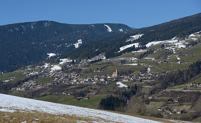
Klausen (Chiusa)
.svg)
- Italian comune in South Tyrol
 Hiking in Klausen
Klausen (Chiusa) is a charming town located in South Tyrol, Italy, known for its stunning landscapes, rich history, and excellent hiking opportunities. Nestled in the Val Gardena valley, Klausen offers access to various hiking trails suitable for different skill levels. Here are some highlights about hiking in the area:
Trails and Routes:
-
Klausen to the Villnöss Valley: This is a beautiful trail that takes you through lush meadows and provides stunning views of the Dolomites. The Villnöss Valley is particularly noted for its diverse flora and fauna.
-
Puez-Odle Nature Park: This UNESCO World Heritage site offers a network of trails that vary in difficulty. You can enjoy breathtaking panoramic views, towering limestone peaks, and unique geological formations.
-
Sella Pass: Accessible from Klausen, the Sella Pass offers numerous hiking trails with varying levels of difficulty. The area is well-known for its spectacular mountain scenery.
-
The Eisack Valley: There are multiple routes along the valley, where you can experience the natural beauty interspersed with traditional South Tyrolean farms.
Tips for Hiking in Klausen:
- Prepare for Weather Changes: The weather in the mountains can change rapidly, so dress in layers and be prepared for sudden rain or temperature drops.
- Hydration and Snacks: Always carry enough water and some high-energy snacks, especially on longer hikes.
- Trail Maps: Make sure to have a good trail map or a GPS device. Local tourist information centers can provide maps and advice on current trail conditions.
- Respect Nature: Stay on marked trails, and remember to take your litter back with you.
Best Times to Hike:
- Spring and Early Summer (May to June): The wildflowers are in bloom, and the temperatures are moderate.
- Early Fall (September to October): The weather is often still pleasant, and the autumn colors provide a beautiful backdrop.
Local Resources:
- Guided Tours: If you're new to hiking or would like to explore off the beaten path, consider joining a guided hiking tour.
- Visitor Centers: The local tourist information centers can help with trail recommendations, accommodations, and other resources.
Klausen is a fantastic base for hikers looking to explore the natural beauty of the Dolomites, with options for everyone from casual walkers to experienced trekkers. Enjoy your hiking adventure!
- Country:

- Postal Code: 39043
- Local Dialing Code: 0472
- Licence Plate Code: BZ
- Coordinates: 46° 38' 24" N, 11° 33' 57" E


- GPS tracks (wikiloc): [Link]
- AboveSeaLevel: 523 м m
- Area: 51.29 sq km
- Population: 5211
- Web site: http://www.comune.chiusa.bz.it
- Wikipedia en: wiki(en)
- Wikipedia: wiki(it)
- Wikidata storage: Wikidata: Q378095
- Wikipedia Commons Gallery: [Link]
- Wikipedia Commons Category: [Link]
- Freebase ID: [/m/0g9gg1]
- GeoNames ID: Alt: [6535893]
- VIAF ID: Alt: [133162153]
- OSM relation ID: [47292]
- GND ID: Alt: [4030978-2]
- Library of Congress authority ID: Alt: [n83198627]
- UN/LOCODE: [ITCU9]
- Digital Atlas of the Roman Empire ID: [10724]
- ISTAT ID: 021022
- Italian cadastre code: C652
Shares border with regions:


Sarntal
- Italian comune
Hiking in Sarntal
Sarntal, also known as the Sarntal Valley, is a beautiful hiking destination located in South Tyrol, Italy, just north of Bolzano. This area is known for its stunning landscapes, diverse flora and fauna, and rich cultural heritage. Here are some key points to consider when planning a hiking trip in Sarntal:...
- Country:
- Postal Code: 39058
- Local Dialing Code: 0471
- Licence Plate Code: BZ
- Coordinates: 46° 38' 37" N, 11° 21' 22" E
- GPS tracks (wikiloc): [Link]
- AboveSeaLevel: 2781 м m
- Area: 302.27 sq km
- Population: 7058
- Web site: [Link]

Villnöß
- Italian comune
Hiking in Villnöß
Villnöß, or Villnöß Valley, is a beautiful hiking destination located in South Tyrol, Northern Italy. Nestled at the foot of the Dolomites, it offers stunning landscapes, diverse trails, and an opportunity to experience both nature and local culture. Here are some highlights about hiking in this picturesque area:...
- Country:
- Postal Code: 39040
- Local Dialing Code: 0472
- Licence Plate Code: BZ
- Coordinates: 46° 38' 34" N, 11° 40' 42" E
- GPS tracks (wikiloc): [Link]
- AboveSeaLevel: 1132 м m
- Area: 81.38 sq km
- Population: 2603
- Web site: [Link]


Lajen
- Italian comune
Hiking in Lajen
Lajen, or Laion, is a picturesque village located in the South Tyrol region of northern Italy, known for its stunning scenery and outdoor recreational opportunities, including hiking. The area is nestled in the Val Gardena valley, surrounded by the breathtaking Dolomites, a UNESCO World Heritage Site, which offers a wealth of hiking trails for all levels of experience....
- Country:
- Postal Code: 39040
- Local Dialing Code: 0471
- Licence Plate Code: BZ
- Coordinates: 46° 36' 29" N, 11° 33' 56" E
- GPS tracks (wikiloc): [Link]
- AboveSeaLevel: 1093 м m
- Area: 37.53 sq km
- Population: 2675
- Web site: [Link]


Feldthurns
- Italian comune
Hiking in Feldthurns
Feldthurns (or Velthurns) is a quaint village located in South Tyrol, Italy, known for its stunning landscapes and excellent hiking opportunities. Nestled within the foothills of the Alps, it provides access to various trails that cater to different skill levels, making it an excellent destination for both novice hikers and seasoned trekkers....
- Country:
- Postal Code: 39040
- Local Dialing Code: 0472
- Licence Plate Code: BZ
- Coordinates: 46° 40' 1" N, 11° 35' 50" E
- GPS tracks (wikiloc): [Link]
- AboveSeaLevel: 851 м m
- Area: 24.58 sq km
- Population: 2873
- Web site: [Link]


Vahrn
- Italian comune
Hiking in Vahrn
Vahrn, located in South Tyrol, Italy, is a charming village surrounded by stunning natural landscapes, making it a great destination for hiking enthusiasts. The area is characterized by its picturesque mountain scenery, rolling hills, and vineyards, offering various trails suitable for hikers of all levels....
- Country:
- Postal Code: 39040
- Local Dialing Code: 0472
- Licence Plate Code: BZ
- Coordinates: 46° 44' 20" N, 11° 38' 15" E
- GPS tracks (wikiloc): [Link]
- AboveSeaLevel: 671 м m
- Area: 70.34 sq km
- Population: 4546
- Web site: [Link]

Villanders
- Italian comune
Hiking in Villanders
Villanders, located in South Tyrol, Italy, is a picturesque village that offers a variety of hiking opportunities amidst stunning alpine scenery. Here are some highlights for hiking in this area:...
- Country:
- Postal Code: 39043
- Local Dialing Code: 0472
- Licence Plate Code: BZ
- Coordinates: 46° 37' 51" N, 11° 32' 13" E
- GPS tracks (wikiloc): [Link]
- AboveSeaLevel: 880 м m
- Area: 43.95 sq km
- Population: 1853
- Web site: [Link]