La Berthenoux (La Berthenoux)

- commune in Indre, France
- Country:

- Postal Code: 36400
- Coordinates: 46° 39' 40" N, 2° 3' 43" E


- GPS tracks (wikiloc): [Link]
- Area: 39.82 sq km
- Population: 416
- Web site: http://www.mairie-la-berthenoux.fr
- Wikipedia en: wiki(en)
- Wikipedia: wiki(fr)
- Wikidata storage: Wikidata: Q1060738
- Wikipedia Commons Category: [Link]
- Freebase ID: [/m/03nv92z]
- GeoNames ID: Alt: [3011085]
- SIREN number: [213600174]
- BnF ID: [15257321q]
- VIAF ID: Alt: [144241816]
- Library of Congress authority ID: Alt: [n80037431]
- INSEE municipality code: 36017
Shares border with regions:

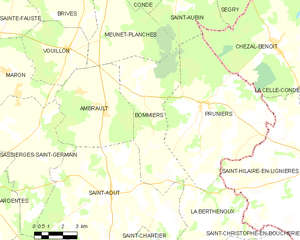
Bommiers
- commune in Indre, France
- Country:
- Postal Code: 36120
- Coordinates: 46° 47' 41" N, 1° 59' 7" E
- GPS tracks (wikiloc): [Link]
- Area: 28.38 sq km
- Population: 303


Verneuil-sur-Igneraie
- commune in Indre, France
- Country:
- Postal Code: 36400
- Coordinates: 46° 39' 18" N, 2° 0' 38" E
- GPS tracks (wikiloc): [Link]
- Area: 9.84 sq km
- Population: 318
Pruniers
- commune in Indre, France
- Country:
- Postal Code: 36120
- Coordinates: 46° 47' 20" N, 2° 3' 5" E
- GPS tracks (wikiloc): [Link]
- Area: 49 sq km
- Population: 537
- Web site: [Link]


Saint-Christophe-en-Boucherie
- commune in Indre, France
- Country:
- Postal Code: 36400
- Coordinates: 46° 40' 41" N, 2° 7' 16" E
- GPS tracks (wikiloc): [Link]
- Area: 26.89 sq km
- Population: 250


Saint-Août
- commune in Indre, France
- Country:
- Postal Code: 36120
- Coordinates: 46° 43' 53" N, 1° 57' 56" E
- GPS tracks (wikiloc): [Link]
- Area: 54.11 sq km
- Population: 852
- Web site: [Link]
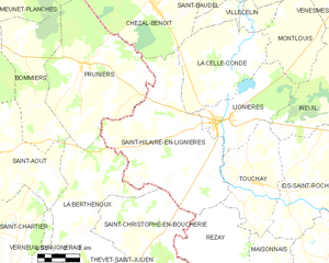
Saint-Hilaire-en-Lignières
- commune in Cher, France
- Country:
- Postal Code: 18160
- Coordinates: 46° 43' 34" N, 2° 10' 25" E
- GPS tracks (wikiloc): [Link]
- Area: 53.78 sq km
- Population: 515

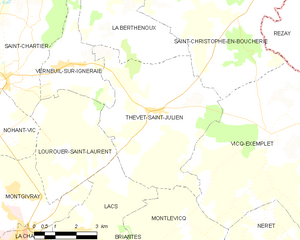
Thevet-Saint-Julien
- commune in Indre, France
- Country:
- Postal Code: 36400
- Coordinates: 46° 38' 14" N, 2° 4' 8" E
- GPS tracks (wikiloc): [Link]
- Area: 30.94 sq km
- Population: 402


Saint-Chartier
- commune in Indre, France
- Country:
- Postal Code: 36400
- Coordinates: 46° 38' 59" N, 1° 58' 38" E
- GPS tracks (wikiloc): [Link]
- Area: 27.52 sq km
- Population: 532