Saint-Georges-de-Lévéjac (Saint-Georges-de-Lévéjac)

- former commune in Lozère, France
- Country:

- Postal Code: 48500
- Coordinates: 44° 19' 9" N, 3° 13' 51" E


- GPS tracks (wikiloc): [Link]
- Area: 56.26 sq km
- Population: 250
- Web site: http://st-georges-de-levejac.com
- Wikipedia en: wiki(en)
- Wikipedia: wiki(fr)
- Wikidata storage: Wikidata: Q381516
- Wikipedia Commons Category: [Link]
- Freebase ID: [/m/02z0xd2]
- Freebase ID: [/m/02z0xd2]
- GeoNames ID: Alt: [6435154]
- GeoNames ID: Alt: [6435154]
- BnF ID: [15261558c]
- BnF ID: [15261558c]
- PACTOLS thesaurus ID: [pcrt3ueq2ppWHw]
- PACTOLS thesaurus ID: [pcrt3ueq2ppWHw]
- INSEE municipality code: 48154
- INSEE municipality code: 48154
Shares border with regions:

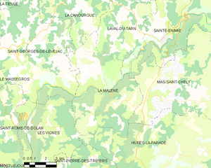
La Malène
- commune in Lozère, France
- Country:
- Postal Code: 48210
- Coordinates: 44° 18' 9" N, 3° 19' 13" E
- GPS tracks (wikiloc): [Link]
- Area: 40.68 sq km
- Population: 148
- Web site: [Link]
Le Recoux
- former commune in Lozère, France
- Country:
- Postal Code: 48500
- Coordinates: 44° 20' 16" N, 3° 8' 50" E
- GPS tracks (wikiloc): [Link]
- Area: 23.69 sq km
- Population: 129


La Canourgue
- commune in Lozère, France
- Country:
- Postal Code: 48500
- Coordinates: 44° 25' 58" N, 3° 12' 53" E
- GPS tracks (wikiloc): [Link]
- Area: 104.29 sq km
- Population: 2090
- Web site: [Link]

Saint-Rome-de-Dolan
- former commune in Lozère, France
- Country:
- Postal Code: 48500
- Coordinates: 44° 16' 25" N, 3° 12' 57" E
- GPS tracks (wikiloc): [Link]
- Area: 32.63 sq km
- Population: 64


Les Vignes
- former commune in Lozère, France
- Country:
- Postal Code: 48210
- Coordinates: 44° 16' 40" N, 3° 13' 38" E
- GPS tracks (wikiloc): [Link]
- Area: 28.84 sq km
- Population: 101
La Tieule
- commune in Lozère, France
- Country:
- Postal Code: 48500
- Coordinates: 44° 23' 2" N, 3° 9' 23" E
- GPS tracks (wikiloc): [Link]
- Area: 24 sq km
- Population: 88


Le Massegros
- former commune in Lozère, France
- Country:
- Postal Code: 48500
- Coordinates: 44° 18' 32" N, 3° 10' 28" E
- GPS tracks (wikiloc): [Link]
- Area: 17.94 sq km
- Population: 405