Vallouise (Vallouise)
- former commune in Hautes-Alpes, France
 Hiking in Vallouise
Vallouise, located in the French Alps within the Ecrins National Park, is a stunning destination for hiking enthusiasts. The area is renowned for its breathtaking mountain landscapes, diverse ecosystems, and a variety of trails suitable for all levels of hikers.
Key Features of Hiking in Vallouise:
-
Diverse Trails: Vallouise offers a wide range of hiking trails, from easy walks suitable for families to challenging routes for experienced trekkers. The paths take you through stunning alpine scenery, including meadows, forests, and rugged mountain terrain.
-
Spectacular Views: Many trails offer breathtaking views of the surrounding peaks, including the famous Barre des Écrins, which is the highest peak in the Écrins range. Look forward to picturesque vistas, especially during sunrise and sunset.
-
Wildlife: The region is home to a variety of fauna and flora. While hiking, you may spot animals such as ibex, chamois, marmots, and various bird species, making it a paradise for nature lovers.
-
Seasonal Activities: Hiking is popular in the summer months, with trails generally accessible from late spring to early autumn. In winter, the area transforms into a hub for skiing and snowshoeing.
-
Local Culture: The villages around Vallouise, like Pelvoux and Vallouise itself, offer a glimpse into traditional Alpine culture. You can explore charming architecture, local cuisine, and historic sites after a day on the trails.
-
Guided Tours: If you're unfamiliar with the area, consider booking a guided hike. Local guides can provide insights into the geography, wildlife, and history of the region.
Recommended Hikes:
- Lac de la Pisse: A moderate hike that takes you to a beautiful glacial lake with stunning mountain backdrops.
- Col de la Basse: A more challenging trek that offers breathtaking panoramic views and a chance to experience the rugged wilderness.
- Le Queyras: Just a short drive away, this area has numerous hiking opportunities that are well worth exploring.
Tips for Hiking in Vallouise:
- Prepare for Weather Changes: Mountain weather can change rapidly, so be sure to pack layers and prepare for rain or colder temperatures even in summer.
- Stay Hydrated: Carry enough water, as trails can be challenging, and access to water sources may be limited.
- Respect Nature: Stay on marked trails to protect the local flora and fauna, and be mindful of the leave-no-trace principles.
Overall, Vallouise is a fantastic choice for hiking, combining stunning natural beauty with rich cultural experiences. Whether you're looking for a day hike or multi-day trekking routes, you'll find something that suits your adventure needs!
- Country:

- Postal Code: 05290
- Coordinates: 44° 50' 42" N, 6° 29' 13" E


- GPS tracks (wikiloc): [Link]
- Area: 68.58 sq km
- Population: 758
- Wikipedia en: wiki(en)
- Wikipedia: wiki(fr)
- Wikidata storage: Wikidata: Q1085684
- Wikipedia Commons Category: [Link]
- Freebase ID: [/m/03mfnhd]
- Freebase ID: [/m/03mfnhd]
- GeoNames ID: Alt: [6425655]
- GeoNames ID: Alt: [6425655]
- VIAF ID: Alt: [247813108]
- VIAF ID: Alt: [247813108]
- MusicBrainz area ID: [1e4ae361-eb62-4943-a2b1-14ee1696f698]
- MusicBrainz area ID: [1e4ae361-eb62-4943-a2b1-14ee1696f698]
- INSEE municipality code: 05175
- INSEE municipality code: 05175
Shares border with regions:

Les Vigneaux
- commune in Hautes-Alpes, France
Hiking in Les Vigneaux
Les Vigneaux is a charming village located in the stunning Ecrins National Park in the French Alps. It is an excellent destination for hiking enthusiasts, featuring a variety of trails that cater to different skill levels. Here are some highlights about hiking in and around Les Vigneaux:...
- Country:
- Postal Code: 05120
- Coordinates: 44° 49' 26" N, 6° 32' 27" E
- GPS tracks (wikiloc): [Link]
- Area: 15.99 sq km
- Population: 521

Puy-Saint-Vincent
- commune in Hautes-Alpes, France
Hiking in Puy-Saint-Vincent
Puy-Saint-Vincent is a scenic destination in the French Alps, located in the Hautes-Alpes region. It's known for its beautiful landscapes and varied hiking trails. Here’s an overview of what you can expect when hiking in this area:...
- Country:
- Postal Code: 05290
- Coordinates: 44° 49' 48" N, 6° 29' 14" E
- GPS tracks (wikiloc): [Link]
- Area: 22.98 sq km
- Population: 283
- Web site: [Link]

Pelvoux
- former commune in Hautes-Alpes, France
Hiking in Pelvoux
Pelvoux is a beautiful region located in the French Alps, specifically in the Ecrins National Park. It's known for its stunning mountain landscapes, varied hiking trails, and breathtaking views. Here are some key points to keep in mind when planning a hiking trip to Pelvoux:...
- Country:
- Postal Code: 05340
- Coordinates: 44° 52' 9" N, 6° 29' 12" E
- GPS tracks (wikiloc): [Link]
- Area: 76.23 sq km
- Population: 483

Saint-Martin-de-Queyrières
- commune in Hautes-Alpes, France
Hiking in Saint-Martin-de-Queyrières
Saint-Martin-de-Queyrières is a charming village located in the Hautes-Alpes region of France. It's a fantastic starting point for hiking enthusiasts as it offers access to stunning landscapes, diverse trails, and beautiful views of the Écrins National Park and surrounding mountains. Here are some highlights regarding hiking in this area:...
- Country:
- Postal Code: 05120
- Coordinates: 44° 50' 25" N, 6° 35' 7" E
- GPS tracks (wikiloc): [Link]
- AboveSeaLevel: 1200 м m
- Area: 55.52 sq km
- Population: 1131

La Chapelle-en-Valgaudémar
- commune in Hautes-Alpes, France
Hiking in La Chapelle-en-Valgaudémar
La Chapelle-en-Valgaudémar is a picturesque village located in the heart of the Écrins National Park in the French Alps. This area is renowned for its stunning natural beauty, rugged mountains, and a variety of hiking trails suitable for different skill levels....
- Country:
- Postal Code: 05800
- Coordinates: 44° 49' 1" N, 6° 11' 41" E
- GPS tracks (wikiloc): [Link]
- AboveSeaLevel: 1050 м m
- Area: 108.02 sq km
- Population: 101

L'Argentière-la-Bessée
- commune in Hautes-Alpes, France
Hiking in L'Argentière-la-Bessée
L'Argentière-la-Bessée, located in the Hautes-Alpes region of France, is a picturesque village surrounded by stunning mountain ranges, making it a fantastic destination for hiking enthusiasts. Here are some highlights and tips for hiking in this area:...
- Country:
- Postal Code: 05120
- Coordinates: 44° 47' 40" N, 6° 33' 33" E
- GPS tracks (wikiloc): [Link]
- Area: 64.55 sq km
- Population: 2307

Champoléon
- commune in Hautes-Alpes, France
Hiking in Champoléon
Champoléon is a beautiful valley located in the Écrins National Park in the French Alps, known for its stunning landscapes, diverse flora and fauna, and a variety of hiking trails suitable for different skill levels. Here are some key points to consider when hiking in Champoléon:...
- Country:
- Postal Code: 05260
- Coordinates: 44° 43' 14" N, 6° 15' 40" E
- GPS tracks (wikiloc): [Link]
- Area: 98.54 sq km
- Population: 148

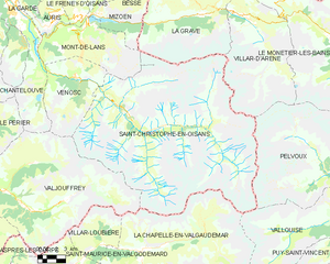
Saint-Christophe-en-Oisans
- commune in Isère, France
Hiking in Saint-Christophe-en-Oisans
Saint-Christophe-en-Oisans is a charming village located in the French Alps, nestled within the Oisans valley. It serves as a gateway to some stunning hiking opportunities in the surrounding terrain, known for its breathtaking scenery, diverse ecosystems, and the proximity to the Écrins National Park....
- Country:
- Postal Code: 38520
- Coordinates: 44° 57' 26" N, 6° 10' 37" E
- GPS tracks (wikiloc): [Link]
- Area: 123.5 sq km
- Population: 105
- Web site: [Link]