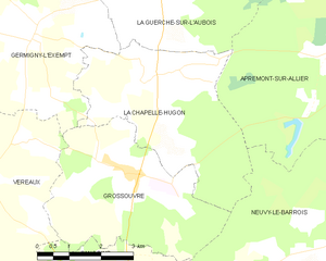
La Guerche-sur-l'Aubois (La Guerche-sur-l'Aubois)

- commune in Cher, France
- Country:

- Postal Code: 18150
- Coordinates: 46° 57' 4" N, 2° 56' 51" E


- GPS tracks (wikiloc): [Link]
- Area: 52.7 sq km
- Population: 3322
- Web site: http://www.mairie-laguerchesurlaubois.fr/
- Wikipedia en: wiki(en)
- Wikipedia: wiki(fr)
- Wikidata storage: Wikidata: Q1163750
- Wikipedia Commons Category: [Link]
- Freebase ID: [/m/03mfcxg]
- GeoNames ID: Alt: [6455653]
- SIREN number: [211801089]
- BnF ID: [152494547]
- VIAF ID: Alt: [133657327]
- SUDOC authorities ID: [034600299]
- INSEE municipality code: 18108
Shares border with regions:

La Chapelle-Hugon
- commune in Cher, France
- Country:
- Postal Code: 18150
- Coordinates: 46° 54' 25" N, 2° 56' 54" E
- GPS tracks (wikiloc): [Link]
- Area: 16.16 sq km
- Population: 394

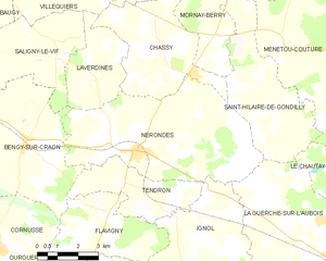
Nérondes
- commune in Cher, France
- Country:
- Postal Code: 18350
- Coordinates: 46° 59' 51" N, 2° 49' 10" E
- GPS tracks (wikiloc): [Link]
- Area: 34 sq km
- Population: 1526
- Web site: [Link]


Cuffy
- commune in Cher, France
- Country:
- Postal Code: 18150
- Coordinates: 46° 57' 39" N, 3° 3' 9" E
- GPS tracks (wikiloc): [Link]
- Area: 34.57 sq km
- Population: 1097
- Web site: [Link]
Le Chautay
- commune in Cher, France
- Country:
- Postal Code: 18150
- Coordinates: 46° 58' 37" N, 2° 58' 0" E
- GPS tracks (wikiloc): [Link]
- Area: 14.74 sq km
- Population: 304

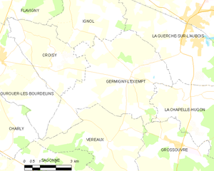
Germigny-l'Exempt
- commune in Cher, France
- Country:
- Postal Code: 18150
- Coordinates: 46° 55' 5" N, 2° 53' 54" E
- GPS tracks (wikiloc): [Link]
- Area: 28.26 sq km
- Population: 311


Saint-Hilaire-de-Gondilly
- commune in Cher, France
- Country:
- Postal Code: 18320
- Coordinates: 47° 2' 58" N, 2° 53' 10" E
- GPS tracks (wikiloc): [Link]
- Area: 18.42 sq km
- Population: 177

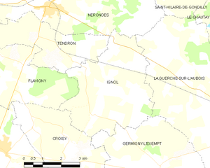
Ignol
- commune in Cher, France
- Country:
- Postal Code: 18350
- Coordinates: 46° 58' 0" N, 2° 50' 47" E
- GPS tracks (wikiloc): [Link]
- Area: 17.67 sq km
- Population: 180

Apremont-sur-Allier
- commune in Cher, France
- Country:
- Postal Code: 18150
- Coordinates: 46° 54' 21" N, 3° 2' 52" E
- GPS tracks (wikiloc): [Link]
- AboveSeaLevel: 176 м m
- Area: 30.69 sq km
- Population: 71
- Web site: [Link]