La Pacaudière (La Pacaudière)

- commune in Loire, France
- Country:

- Postal Code: 42310
- Coordinates: 46° 10' 32" N, 3° 52' 3" E


- GPS tracks (wikiloc): [Link]
- Area: 20.61 sq km
- Population: 1044
- Web site: http://www.la-pacaudiere.fr/
- Wikipedia en: wiki(en)
- Wikipedia: wiki(fr)
- Wikidata storage: Wikidata: Q1106957
- Wikipedia Commons Category: [Link]
- Freebase ID: [/m/03nwbn_]
- Freebase ID: [/m/03nwbn_]
- GeoNames ID: Alt: [6456010]
- GeoNames ID: Alt: [6456010]
- SIREN number: [214201634]
- SIREN number: [214201634]
- BnF ID: [15259731m]
- BnF ID: [15259731m]
- INSEE municipality code: 42163
- INSEE municipality code: 42163
Shares border with regions:


Le Crozet
- commune in Loire, France
- Country:
- Postal Code: 42310
- Coordinates: 46° 10' 14" N, 3° 51' 18" E
- GPS tracks (wikiloc): [Link]
- AboveSeaLevel: 450 м m
- Area: 13.31 sq km
- Population: 282
- Web site: [Link]

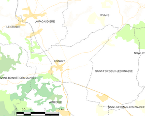
Changy
- commune in Loire, France
- Country:
- Postal Code: 42310
- Coordinates: 46° 8' 31" N, 3° 53' 28" E
- GPS tracks (wikiloc): [Link]
- Area: 13.67 sq km
- Population: 624
- Web site: [Link]


Vivans
- commune in Loire, France
- Country:
- Postal Code: 42310
- Coordinates: 46° 11' 22" N, 3° 56' 33" E
- GPS tracks (wikiloc): [Link]
- Area: 25.16 sq km
- Population: 232


Saint-Martin-d'Estréaux
- commune in Loire, France
- Country:
- Postal Code: 42620
- Coordinates: 46° 12' 22" N, 3° 47' 55" E
- GPS tracks (wikiloc): [Link]
- Area: 29.6 sq km
- Population: 858
- Web site: [Link]


Urbise
- commune in Loire, France
- Country:
- Postal Code: 42310
- Coordinates: 46° 15' 15" N, 3° 53' 32" E
- GPS tracks (wikiloc): [Link]
- Area: 15.5 sq km
- Population: 132

Chenay-le-Châtel
- commune in Saône-et-Loire, France
- Country:
- Postal Code: 71340
- Coordinates: 46° 13' 39" N, 3° 56' 22" E
- GPS tracks (wikiloc): [Link]
- Area: 32.14 sq km
- Population: 395