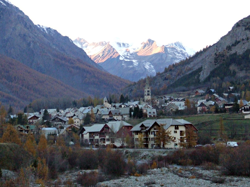
Névache (Névache)
- commune in Hautes-Alpes, France
 Hiking in Névache
Névache, located in the Hautes-Alpes region of France, is a beautiful destination for hiking enthusiasts. Nestled in the Écrins National Park, Névache is known for its stunning landscapes, including alpine meadows, rugged mountains, and crystal-clear rivers. Here are some highlights and tips for hiking in the area:
Popular Hiking Trails
-
Col de la Claree: This trail offers breathtaking views of the surrounding peaks and is great for experienced hikers. The ascent can be steep in places, but the panoramic vistas from the col are rewarding.
-
Lac de la Clarée: A more moderate hike that leads to a picturesque mountain lake surrounded by towering peaks. It's suitable for families and offers a perfect spot for a picnic.
-
Vallée de la Clarée: Explore this beautiful valley, which presents several trail options ranging from easy walks to more challenging hikes. The scenery is characterized by charming alpine villages and lush greenery.
-
Refuge de Buffère: A hike to this mountain refuge is a fantastic way to experience the remoteness and beauty of the area. The refuge provides a cozy stop for lunch or an overnight stay.
Tips for Hiking in Névache
- Season: The best time for hiking in Névache is typically from late spring to early autumn (June to September) when the weather is mild and the trails are generally clear of snow.
- Preparation: Always check the weather conditions before heading out, and pack the essential gear, including a map, enough water, snacks, sunscreen, and proper clothing for changing conditions.
- Guided Tours: If you're not familiar with the area or prefer companionship, consider joining a guided hike. Local guides can provide valuable insights into the natural history and culture of the region.
- Leave No Trace: Ensure you practice Leave No Trace principles to minimize your impact on the environment. Take all your trash with you and avoid picking plants or disturbing wildlife.
- Local Regulations: Always be aware of and respect any local regulations regarding wildlife, campfires, and trail maintenance.
What to Bring
- Hiking boots with good ankle support
- Layered clothing for temperature changes
- A daypack to carry your supplies
- Navigation tools (map, compass, GPS)
- First-aid kit
Hiking in Névache offers a unique opportunity to experience the natural beauty of the French Alps. With its varied trails and stunning scenery, it’s a place where both seasoned hikers and beginners can find enjoyable routes to explore.
- Country:

- Postal Code: 05100
- Coordinates: 45° 1' 7" N, 6° 36' 17" E


- GPS tracks (wikiloc): [Link]
- Area: 191.93 sq km
- Population: 359
- Web site: http://www.nevache.fr
- Wikipedia en: wiki(en)
- Wikipedia: wiki(fr)
- Wikidata storage: Wikidata: Q588334
- Wikipedia Commons Category: [Link]
- Freebase ID: [/m/03mfmlp]
- Freebase ID: [/m/03mfmlp]
- GeoNames ID: Alt: [6446667]
- GeoNames ID: Alt: [6446667]
- SIREN number: [210500930]
- SIREN number: [210500930]
- VIAF ID: Alt: [247836750]
- VIAF ID: Alt: [247836750]
- PACTOLS thesaurus ID: [pcrtrinusyxEMv]
- PACTOLS thesaurus ID: [pcrtrinusyxEMv]
- INSEE municipality code: 05093
- INSEE municipality code: 05093
Shares border with regions:
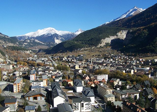
Le Monêtier-les-Bains
- commune in Hautes-Alpes, France
Hiking in Le Monêtier-les-Bains
Le Monêtier-les-Bains, located in the Hautes-Alpes region of France, is a stunning destination for hiking enthusiasts. Nestled in the Serre Chevalier Valley, this alpine village offers a variety of trails that cater to all levels of hikers, from beginners to experienced adventurers. Here are some highlights and tips for hiking in Le Monêtier-les-Bains:...
- Country:
- Postal Code: 05220
- Coordinates: 44° 58' 34" N, 6° 30' 31" E
- GPS tracks (wikiloc): [Link]
- Area: 97.87 sq km
- Population: 1024
- Web site: [Link]

Val-des-Prés
- commune in Hautes-Alpes, France
Hiking in Val-des-Prés
Val-des-Prés is a picturesque commune located in the Alpes-de-Haute-Provence region of France, known for its stunning landscapes and outdoor recreational opportunities, particularly hiking. Here are some key points to consider if you're planning to hike in Val-des-Prés:...
- Country:
- Postal Code: 05100
- Coordinates: 44° 56' 54" N, 6° 40' 42" E
- GPS tracks (wikiloc): [Link]
- Area: 44.77 sq km
- Population: 656
- Web site: [Link]

Modane
- commune in Savoie, France
Hiking in Modane
Modane is a picturesque town located in the Savoie region of the French Alps, known for its stunning landscapes and proximity to various outdoor activities, including hiking. Here are some key points to consider if you're planning to hike in and around Modane:...
- Country:
- Postal Code: 73500
- Coordinates: 45° 12' 5" N, 6° 40' 24" E
- GPS tracks (wikiloc): [Link]
- AboveSeaLevel: 1000 м m
- Area: 71.04 sq km
- Population: 3180
- Web site: [Link]
La Salle-les-Alpes
- commune in Hautes-Alpes, France
Hiking in La Salle-les-Alpes
La Salle-les-Alpes, located in the Hautes-Alpes region of southeastern France, is a fantastic destination for hiking enthusiasts. Nestled in the enchanting Écrins National Park, this charming village offers breathtaking mountain views, diverse landscapes, and a variety of trails suited for all skill levels....
- Country:
- Postal Code: 05240
- Coordinates: 44° 56' 41" N, 6° 34' 15" E
- GPS tracks (wikiloc): [Link]
- AboveSeaLevel: 1397 м m
- Area: 35.42 sq km
- Population: 1003


Valmeinier
- commune in Savoie, France
Hiking in Valmeinier
Valmeinier is a charming mountain resort in the French Alps, located in the Savoie region. It's known for its stunning alpine scenery, making it a fantastic destination for hiking enthusiasts. Here’s what you need to know about hiking in Valmeinier:...
- Country:
- Postal Code: 73450
- Coordinates: 45° 11' 2" N, 6° 28' 54" E
- GPS tracks (wikiloc): [Link]
- Area: 54.26 sq km
- Population: 510
- Web site: [Link]


Orelle
- commune in Savoie, France
Hiking in Orelle
Orelle, a picturesque village located in the French Alps, is an excellent destination for hiking enthusiasts. It is situated near the Maurienne Valley and provides access to a variety of trails that cater to all skill levels, from beginners to advanced hikers....
- Country:
- Postal Code: 73140
- Coordinates: 45° 12' 33" N, 6° 32' 13" E
- GPS tracks (wikiloc): [Link]
- Area: 69.25 sq km
- Population: 352


Valloire
- commune in Savoie, France
Hiking in Valloire
Valloire is a charming mountain village located in the Savoie region of the French Alps. It's known for its stunning landscapes, rich heritage, and excellent opportunities for hiking and outdoor activities. Here are some highlights of hiking in Valloire:...
- Country:
- Postal Code: 73450
- Coordinates: 45° 9' 55" N, 6° 25' 42" E
- GPS tracks (wikiloc): [Link]
- Area: 137.48 sq km
- Population: 1135
- Web site: [Link]

Bardonecchia
- Italian comune
Hiking in Bardonecchia
Bardonecchia, located in the Susa Valley of the Piedmont region of Italy, is a popular destination for hiking enthusiasts, offering a range of trails that cater to different skill levels and preferences. The area is known for its stunning alpine scenery, diverse ecosystems, and rich cultural heritage....
- Country:

- Postal Code: 10052
- Local Dialing Code: 0122
- Licence Plate Code: TO
- Coordinates: 45° 4' 42" N, 6° 42' 14" E
- GPS tracks (wikiloc): [Link]
- AboveSeaLevel: 1312 м m
- Area: 132.2 sq km
- Population: 3155
- Web site: [Link]


Cesana Torinese
- Italian comune
Hiking in Cesana Torinese
Cesana Torinese is a picturesque village located in the Susa Valley in the Piedmont region of Italy, within the Italian Alps. Known for its stunning natural beauty, it offers a variety of hiking opportunities for all skill levels. Here are some key highlights and tips for hiking in this area:...
- Country:
- Postal Code: 10054
- Local Dialing Code: 0122
- Licence Plate Code: TO
- Coordinates: 44° 57' 0" N, 6° 48' 0" E
- GPS tracks (wikiloc): [Link]
- AboveSeaLevel: 1354 м m
- Area: 121.7 sq km
- Population: 945
- Web site: [Link]

Montgenèvre
- commune in Hautes-Alpes, France
Hiking in Montgenèvre
Montgenèvre is a charming village located in the French Alps, right near the Italian border, and it's an excellent destination for hiking enthusiasts. The landscape is characterized by breathtaking mountain views, lush valleys, and a range of trails suitable for various skill levels. Here are some key points about hiking in Montgenèvre:...
- Country:
- Postal Code: 05100
- Coordinates: 44° 55' 51" N, 6° 43' 16" E
- GPS tracks (wikiloc): [Link]
- AboveSeaLevel: 1860 м m
- Area: 40.07 sq km
- Population: 510
- Web site: [Link]
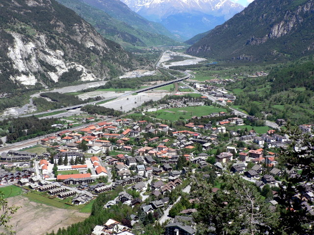

Oulx
- Italian comune
Hiking in Oulx
Oulx is a charming village located in the Susa Valley of the Italian Alps, and it’s a fantastic area for hiking enthusiasts. The region is known for its stunning mountain scenery, diverse trails, and opportunities for outdoor activities....
- Country:
- Postal Code: 10056
- Local Dialing Code: 0122
- Licence Plate Code: TO
- Coordinates: 45° 2' 0" N, 6° 50' 0" E
- GPS tracks (wikiloc): [Link]
- AboveSeaLevel: 1100 м m
- Area: 99.79 sq km
- Population: 3363
- Web site: [Link]