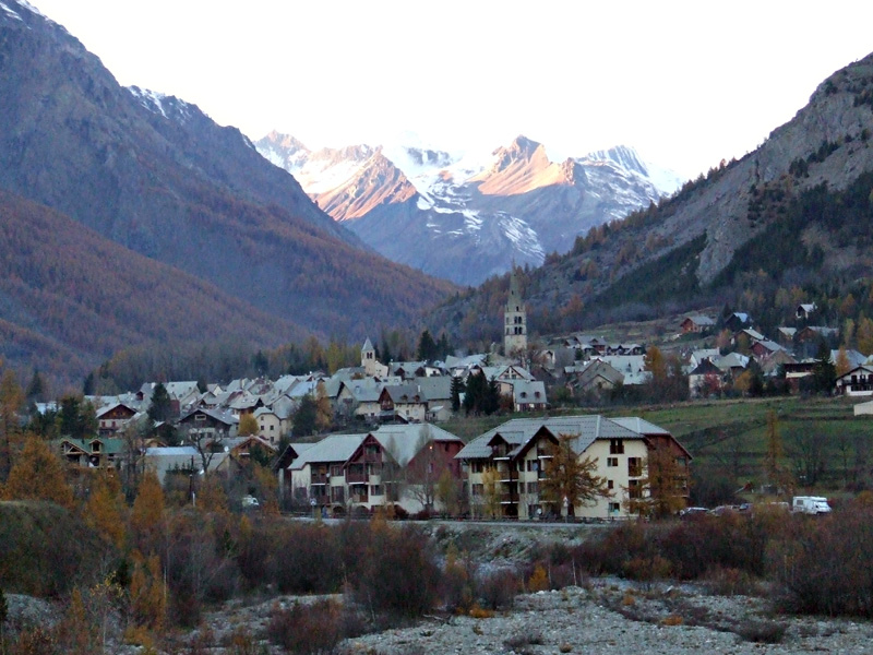
Pelvoux (Pelvoux)
- former commune in Hautes-Alpes, France
 Hiking in Pelvoux
Pelvoux is a beautiful region located in the French Alps, specifically in the Ecrins National Park. It's known for its stunning mountain landscapes, varied hiking trails, and breathtaking views. Here are some key points to keep in mind when planning a hiking trip to Pelvoux:
Hiking Trails:
-
Variety of Trails: Pelvoux offers trails suitable for all levels of hikers, from family-friendly walks to challenging alpine routes. Several paths lead to stunning vistas, glacial lakes, and picturesque villages.
-
La Bérangère Trail: This is a popular trail that offers moderately difficult hiking with spectacular views of the surrounding peaks.
-
Col de l'Étret: An iconic hike that leads you to an alpine pass, offering breathtaking panoramas of the Ecrins massif. This hike can be challenging but is well worth the effort.
-
Loop Trails: Some hiking routes, such as the loop around the village of Pelvoux, are great for families and less experienced hikers, providing beautiful views without being too strenuous.
Best Time to Hike:
-
Summer (June to September): This is the best time for hiking in Pelvoux as the weather is mild, and most trails are accessible. However, it’s advisable to check for snow on higher trails, especially early in the season.
-
Autumn (September to October): The fall season can also be great for hikes with fewer crowds and beautiful autumn foliage.
Wildlife and Nature:
- Pelvoux is home to diverse flora and fauna. Keep an eye out for alpine flowers in summer and perhaps spot wildlife such as chamois, marmots, and various bird species.
Preparation:
-
Gear: Wear sturdy hiking boots, pack weather-appropriate clothing, and don't forget essentials like a first-aid kit, snacks, plenty of water, and a map or GPS device.
-
Local Guidance: Consider hiring a local guide if you're unfamiliar with the area, as they can provide valuable insights and help you navigate the trails safely.
Accommodation:
- Pelvoux has various accommodation options, ranging from campsites and small guesthouses to hotels. Booking in advance, especially during peak seasons, is highly recommended.
Safety Notes:
- Always inform someone about your hiking plans and estimated return time. Be mindful of weather conditions, which can change rapidly in the mountains.
Pelvoux and the surrounding Ecrins National Park are truly stunning hiking destinations. Proper planning will ensure a safe and enjoyable hiking experience amidst the alpine beauty!
- Country:

- Postal Code: 05340
- Coordinates: 44° 52' 9" N, 6° 29' 12" E


- GPS tracks (wikiloc): [Link]
- Area: 76.23 sq km
- Population: 483
- Wikipedia en: wiki(en)
- Wikipedia: wiki(fr)
- Wikidata storage: Wikidata: Q1087588
- Wikipedia Commons Category: [Link]
- Freebase ID: [/m/04mymx]
- Freebase ID: [/m/04mymx]
- GeoNames ID: Alt: [6615729]
- GeoNames ID: Alt: [6615729]
- PACTOLS thesaurus ID: [pcrt6KSOx6bX7u]
- PACTOLS thesaurus ID: [pcrt6KSOx6bX7u]
- INSEE municipality code: 05101
- INSEE municipality code: 05101
Shares border with regions:
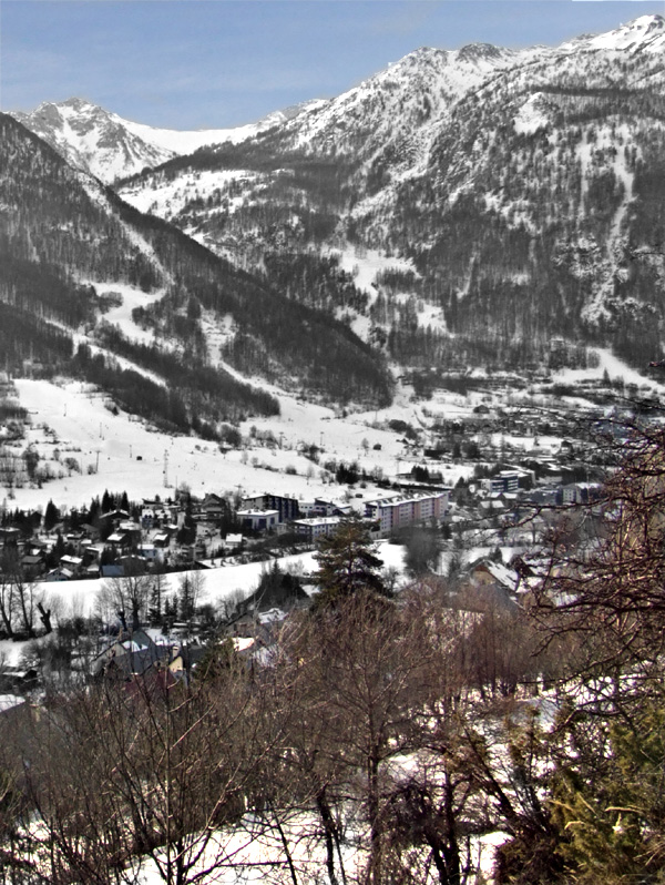
Le Monêtier-les-Bains
- commune in Hautes-Alpes, France
Hiking in Le Monêtier-les-Bains
Le Monêtier-les-Bains, located in the Hautes-Alpes region of France, is a stunning destination for hiking enthusiasts. Nestled in the Serre Chevalier Valley, this alpine village offers a variety of trails that cater to all levels of hikers, from beginners to experienced adventurers. Here are some highlights and tips for hiking in Le Monêtier-les-Bains:...
- Country:
- Postal Code: 05220
- Coordinates: 44° 58' 34" N, 6° 30' 31" E
- GPS tracks (wikiloc): [Link]
- Area: 97.87 sq km
- Population: 1024
- Web site: [Link]

Villar-d'Arêne
- commune in Hautes-Alpes, France
Hiking in Villar-d'Arêne
Villar-d'Arêne is a charming village located in the Écrins National Park in the French Alps, known for its stunning natural beauty and a variety of hiking opportunities. Here are some key aspects of hiking in this area:...
- Country:
- Postal Code: 05480
- Coordinates: 45° 2' 34" N, 6° 20' 13" E
- GPS tracks (wikiloc): [Link]
- Area: 77.51 sq km
- Population: 330
- Web site: [Link]

Vallouise
- former commune in Hautes-Alpes, France
Hiking in Vallouise
Vallouise, located in the French Alps within the Ecrins National Park, is a stunning destination for hiking enthusiasts. The area is renowned for its breathtaking mountain landscapes, diverse ecosystems, and a variety of trails suitable for all levels of hikers....
- Country:
- Postal Code: 05290
- Coordinates: 44° 50' 42" N, 6° 29' 13" E
- GPS tracks (wikiloc): [Link]
- Area: 68.58 sq km
- Population: 758

Puy-Saint-André
- commune in Hautes-Alpes, France
Hiking in Puy-Saint-André
Puy-Saint-André is a charming village located in the Hautes-Alpes region of southeastern France, and it serves as a wonderful base for hiking enthusiasts. Nestled near the Écrins National Park, the area boasts stunning alpine scenery, diverse flora and fauna, and a range of trails suitable for various skill levels....
- Country:
- Postal Code: 05100
- Coordinates: 44° 52' 44" N, 6° 35' 55" E
- GPS tracks (wikiloc): [Link]
- Area: 15.37 sq km
- Population: 466

Saint-Martin-de-Queyrières
- commune in Hautes-Alpes, France
Hiking in Saint-Martin-de-Queyrières
Saint-Martin-de-Queyrières is a charming village located in the Hautes-Alpes region of France. It's a fantastic starting point for hiking enthusiasts as it offers access to stunning landscapes, diverse trails, and beautiful views of the Écrins National Park and surrounding mountains. Here are some highlights regarding hiking in this area:...
- Country:
- Postal Code: 05120
- Coordinates: 44° 50' 25" N, 6° 35' 7" E
- GPS tracks (wikiloc): [Link]
- AboveSeaLevel: 1200 м m
- Area: 55.52 sq km
- Population: 1131
La Salle-les-Alpes
- commune in Hautes-Alpes, France
Hiking in La Salle-les-Alpes
La Salle-les-Alpes, located in the Hautes-Alpes region of southeastern France, is a fantastic destination for hiking enthusiasts. Nestled in the enchanting Écrins National Park, this charming village offers breathtaking mountain views, diverse landscapes, and a variety of trails suited for all skill levels....
- Country:
- Postal Code: 05240
- Coordinates: 44° 56' 41" N, 6° 34' 15" E
- GPS tracks (wikiloc): [Link]
- AboveSeaLevel: 1397 м m
- Area: 35.42 sq km
- Population: 1003

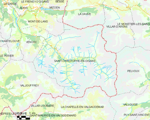
Saint-Christophe-en-Oisans
- commune in Isère, France
Hiking in Saint-Christophe-en-Oisans
Saint-Christophe-en-Oisans is a charming village located in the French Alps, nestled within the Oisans valley. It serves as a gateway to some stunning hiking opportunities in the surrounding terrain, known for its breathtaking scenery, diverse ecosystems, and the proximity to the Écrins National Park....
- Country:
- Postal Code: 38520
- Coordinates: 44° 57' 26" N, 6° 10' 37" E
- GPS tracks (wikiloc): [Link]
- Area: 123.5 sq km
- Population: 105
- Web site: [Link]