
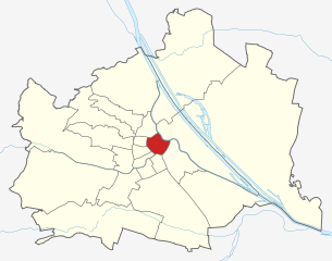
Landstraße (Landstraße)
.svg)
- 3rd municipal District of Vienna, Austria
 Hiking in Landstraße
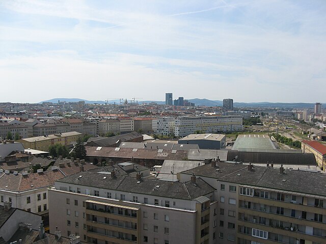
Landstraße, located in Vienna, Austria, is not traditionally known for hiking, as it is primarily an urban district. However, there are plenty of walking and exploration opportunities in and around this area, especially for those interested in urban hikes or scenic walks.
-
Parks and Green Spaces: Landstraße is home to several parks where you can enjoy leisurely walks or runs. The most notable is the Stadtpark, which features beautiful walking paths, ponds, and sculptures. It's a great spot to relax and enjoy nature within the city.
-
Nearby Hiking Trails: While Landstraße itself may not have extensive hiking trails, you can easily access the Vienna Woods (Wienerwald), which is a short distance away. This forested region offers numerous hiking trails, suitable for various skill levels and providing beautiful views of the city and surrounding landscapes.
-
Urban Exploration: You can create your own urban hiking experience by exploring the historical architecture, vibrant neighborhoods, and local eateries in Landstraße. The area is also known for its cultural sites, such as the Belvedere Palace, which you can incorporate into a walking tour.
-
Getting There: If you want a hiking experience beyond Landstraße, public transport can take you quickly to hiking spots in the Vienna Woods or the surrounding areas, where you'll find well-marked trails, nature reserves, and even some challenging routes.
-
Tips: Be sure to wear comfortable footwear, carry water, and check local weather conditions. If venturing into the Vienna Woods or other natural areas, a hiking map or app can be helpful to navigate trails.
In summary, while Landstraße itself doesn't offer traditional hiking, it serves as a great jump-off point for urban walks and access to nearby nature trails.
- Country:

- Postal Code: 1030
- Licence Plate Code: W
- Coordinates: 48° 11' 47" N, 16° 23' 45" E


- GPS tracks (wikiloc): [Link]
- AboveSeaLevel: 178 м m
- Area: 7.39 sq km
- Web site: http://www.wien.gv.at/bezirke/landstrasse/
- Wikipedia en: wiki(en)
- Wikipedia: wiki(de)
- Wikidata storage: Wikidata: Q519552
- Wikipedia Commons Gallery: [Link]
- Wikipedia Commons Category: [Link]
- Freebase ID: [/m/01sr0g]
- GeoNames ID: Alt: [2773040]
- VIAF ID: Alt: [154039581]
- GND ID: Alt: [4196533-4]
- archINFORM location ID: [3683]
- Library of Congress authority ID: Alt: [nr88006437]
- Austrian municipality key: [90301]
Shares border with regions:


Leopoldstadt
- 2nd municipal District of Vienna, Austria
Hiking in Leopoldstadt
Leopoldstadt is the second district of Vienna, Austria, known for its vibrant culture, parks, and proximity to the Danube River. While it may not offer traditional hiking trails found in mountainous regions, there are still great opportunities for outdoor activities and leisurely walks....
- Country:
- Postal Code: 1020
- Licence Plate Code: W
- Coordinates: 48° 12' 37" N, 16° 24' 44" E
- GPS tracks (wikiloc): [Link]
- AboveSeaLevel: 158 м m
- Area: 19.27 sq km
- Web site: [Link]

Innere Stadt
- first district of Vienna
Hiking in Innere Stadt
Innere Stadt, the historic city center of Vienna, Austria, is not typically known for hiking in the traditional sense; however, it offers plenty of opportunities for urban exploration and walking that can be quite enjoyable and fulfilling. The area is rich in history, culture, and stunning architecture, making it an ideal destination for long strolls and leisurely walks....
- Country:
- Postal Code: 1010
- Licence Plate Code: W
- Coordinates: 48° 12' 35" N, 16° 22' 12" E
- GPS tracks (wikiloc): [Link]
- AboveSeaLevel: 192 м m
- Area: 3.01 sq km
- Web site: [Link]

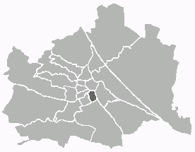
Wieden
- 4. district of Vienna
Hiking in Wieden
Wieden is a charming district in Vienna, Austria, known for its historic architecture, vibrant atmosphere, and cultural significance. While it's not primarily known as a hiking destination, you can find some lovely walking and exploration opportunities in and around Wieden. Here are some suggestions for enjoying the outdoors in and around this area:...
- Country:
- Postal Code: 1040
- Licence Plate Code: W
- Coordinates: 48° 11' 22" N, 16° 21' 42" E
- GPS tracks (wikiloc): [Link]
- AboveSeaLevel: 184 м m
- Area: 1.8 sq km
- Web site: [Link]


Simmering
- 11. district of Vienna
Hiking in Simmering
Simmering is a district in the southeastern part of Vienna, and while it is primarily an urban area, there are some opportunities for enjoyable walks and light hiking in the vicinity. Here are some key points to consider for anyone wanting to explore hiking-like experiences in and around Simmering:...
- Country:
- Postal Code: 1110
- Licence Plate Code: W
- Coordinates: 48° 10' 12" N, 16° 27' 0" E
- GPS tracks (wikiloc): [Link]
- AboveSeaLevel: 156 м m
- Area: 23.27 sq km
- Population: 97333
- Web site: [Link]

Favoriten
- 10. district of Vienna
Hiking in Favoriten
Favoriten is the 10th district of Vienna, Austria, and while it is primarily known as an urban area, it offers some opportunities for hiking and outdoor activities. Here are a few points to consider if you're looking to hike in or near Favoriten:...
- Country:
- Postal Code: 1100
- Licence Plate Code: W
- Coordinates: 48° 9' 28" N, 16° 21' 33" E
- GPS tracks (wikiloc): [Link]
- AboveSeaLevel: 230 м m
- Area: 31.8 sq km
- Web site: [Link]