Laval-d'Aix (Laval-d'Aix)

- commune in Drôme, France
 Hiking in Laval-d'Aix
Laval-d'Aix, located in the Auvergne-Rhône-Alpes region of France, offers stunning scenic beauty and a variety of hiking opportunities. Here are some key points to consider:
Trails and Hiking Options
-
Diverse Terrain: The area around Laval-d'Aix includes varied landscapes, such as forests, hills, and valleys. This range of terrains provides different levels of difficulty for hikers.
-
Marked Trails: There are numerous marked hiking trails suitable for all levels—from gentle walks for beginners to more challenging hikes for experienced hikers. It's a good idea to consult local maps or guides to find the best routes for your ability.
-
Natural Attractions: The region is known for its beautiful flora and fauna, with opportunities for birdwatching and observing local wildlife.
-
Panoramic Views: Some trails may lead you to viewpoints that offer breathtaking vistas of the surrounding mountains and valleys, especially in the Monts du Lyonnais area nearby.
Practical Information
-
Best Time to Hike: Spring and autumn are ideal for hiking in Laval-d'Aix, as the weather is generally mild and the scenery is particularly beautiful during these seasons.
-
Safety Considerations: As with any hiking, be prepared with proper gear, sufficient water, and snacks, especially if you're undertaking longer hikes. Always inform someone of your plans and expected return time.
-
Local Resources: Check in with local tourism offices for updated maps, trail conditions, and any guided hiking options available in the area.
Nearby Attractions
Consider exploring the local culture and history as well—the area has charming villages and historical landmarks worth visiting after your hikes.
In summary, Laval-d'Aix is an excellent choice for hikers looking for a mix of natural beauty, varying trails, and a serene environment. Be sure to prepare well and enjoy the outdoors!
- Country:

- Postal Code: 26150
- Coordinates: 44° 42' 48" N, 5° 25' 53" E


- GPS tracks (wikiloc): [Link]
- Area: 20.05 sq km
- Population: 124
- Wikipedia en: wiki(en)
- Wikipedia: wiki(fr)
- Wikidata storage: Wikidata: Q1085572
- Wikipedia Commons Category: [Link]
- Freebase ID: [/m/03mhhrv]
- SIREN number: [212601595]
- BnF ID: [15253020k]
- INSEE municipality code: 26159
Shares border with regions:


Molières-Glandaz
- former commune in Drôme, France
Hiking in Molières-Glandaz
Molières-Glandaz is a beautiful area nestled in the Auvergne-Rhône-Alpes region of France, known for its stunning landscapes, diverse flora and fauna, and picturesque hiking trails. Here are some highlights and tips for hiking in the Molières-Glandaz area:...
- Country:
- Postal Code: 26150
- Coordinates: 44° 43' 34" N, 5° 23' 57" E
- GPS tracks (wikiloc): [Link]
- Area: 2.87 sq km
- Population: 104


Romeyer
- commune in Drôme, France
Hiking in Romeyer
Romeyer is a beautiful area in the French Alps, often praised for its stunning natural beauty, diverse landscapes, and excellent hiking opportunities. While it may not be as widely known as some other hiking destinations in France, it offers a great experience for those looking to explore the outdoors....
- Country:
- Postal Code: 26150
- Coordinates: 44° 46' 46" N, 5° 24' 32" E
- GPS tracks (wikiloc): [Link]
- Area: 41.46 sq km
- Population: 203

Die
- commune in Drôme, France
Hiking in Die
Die, located in the Drôme department of the Auvergne-Rhône-Alpes region in southeastern France, is a fantastic destination for hiking enthusiasts. This charming town is nestled in the Vercors Massif, surrounded by stunning mountainous landscapes, vineyards, and the richly diverse flora and fauna of the region....
- Country:
- Postal Code: 26150
- Coordinates: 44° 45' 13" N, 5° 22' 13" E
- GPS tracks (wikiloc): [Link]
- Area: 57.28 sq km
- Population: 4576
- Web site: [Link]

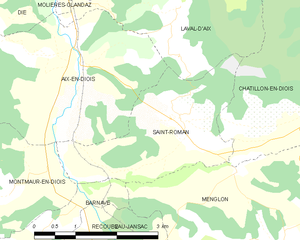
Saint-Roman
- commune in Drôme, France
Hiking in Saint-Roman
Saint-Roman is a charming commune located in the Drôme department of southeastern France, known for its beautiful natural landscapes and outdoor activities. Hiking in this region offers a unique experience, with varying terrains and stunning views of the surrounding mountains and valleys....
- Country:
- Postal Code: 26410
- Coordinates: 44° 41' 29" N, 5° 25' 58" E
- GPS tracks (wikiloc): [Link]
- Area: 7.1 sq km
- Population: 178
- Web site: [Link]


Treschenu-Creyers
- commune in Drôme, France
Hiking in Treschenu-Creyers
Treschenu-Creyers is a picturesque village located in the heart of the French Alps, near the beautiful Vercors National Park. The stunning natural landscape surrounding the village offers many opportunities for hiking enthusiasts of all skill levels. Here’s a brief overview of what you can expect when hiking in the area:...
- Country:
- Postal Code: 26410
- Coordinates: 44° 44' 15" N, 5° 33' 14" E
- GPS tracks (wikiloc): [Link]
- Area: 82.04 sq km
- Population: 112

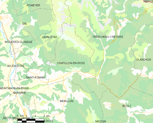
Châtillon-en-Diois
- commune in Drôme, France
Hiking in Châtillon-en-Diois
Châtillon-en-Diois is a picturesque commune located in the Drôme department of France, nestled in the foothills of the Vercors Mountains. It is a great destination for hiking, offering a variety of trails that cater to different skill levels and preferences. Here are some highlights about hiking in and around this beautiful area:...
- Country:
- Postal Code: 26410
- Coordinates: 44° 41' 41" N, 5° 29' 3" E
- GPS tracks (wikiloc): [Link]
- Area: 28.02 sq km
- Population: 555
- Web site: [Link]


Chichilianne
- commune in Isère, France
Hiking in Chichilianne
Chichilianne is a charming village located in the Vercors Regional Natural Park in southeastern France, often referred to as the "Gateway to the Vercors." The area is known for its stunning natural landscapes, including rugged mountains, deep valleys, and diverse flora and fauna, making it an excellent destination for hiking enthusiasts....
- Country:
- Postal Code: 38930
- Coordinates: 44° 48' 42" N, 5° 34' 20" E
- GPS tracks (wikiloc): [Link]
- Area: 62.48 sq km
- Population: 284
- Web site: [Link]