Le Gault-du-Perche (Le Gault-du-Perche)

- commune in Loir-et-Cher, France
- Country:

- Postal Code: 41270
- Coordinates: 48° 5' 42" N, 0° 58' 46" E


- GPS tracks (wikiloc): [Link]
- AboveSeaLevel: 228 м m
- Area: 28.2 sq km
- Population: 330
- Wikipedia en: wiki(en)
- Wikipedia: wiki(fr)
- Wikidata storage: Wikidata: Q1158163
- Wikipedia Commons Category: [Link]
- Freebase ID: [/m/03nw04s]
- GeoNames ID: Alt: [3004122]
- SIREN number: [214100968]
- BnF ID: [152593723]
- INSEE municipality code: 41096
Shares border with regions:


La Fontenelle
- commune in Loir-et-Cher, France
- Country:
- Postal Code: 41270
- Coordinates: 48° 3' 36" N, 1° 1' 28" E
- GPS tracks (wikiloc): [Link]
- Area: 20.1 sq km
- Population: 193
Saint-Avit
- former commune in Loir-et-Cher, France
- Country:
- Postal Code: 41170
- Coordinates: 48° 5' 30" N, 0° 54' 58" E
- GPS tracks (wikiloc): [Link]
- Area: 14.83 sq km
- Population: 98


Le Poislay
- commune in Loir-et-Cher, France
- Country:
- Postal Code: 41270
- Coordinates: 48° 4' 2" N, 1° 3' 59" E
- GPS tracks (wikiloc): [Link]
- Area: 15.89 sq km
- Population: 189
Oigny
- former commune in Loir-et-Cher, France
- Country:
- Postal Code: 41170
- Coordinates: 48° 3' 48" N, 0° 55' 15" E
- GPS tracks (wikiloc): [Link]
- Area: 9.86 sq km
- Population: 91

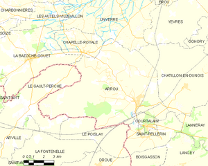
Arrou
- former commune in Eure-et-Loir, France
- Country:
- Postal Code: 28290
- Coordinates: 48° 6' 2" N, 1° 7' 23" E
- GPS tracks (wikiloc): [Link]
- Area: 64.98 sq km
- Population: 1570
- Web site: [Link]


Arville
- former commune in Loir-et-Cher, France
- Country:
- Postal Code: 41170
- Coordinates: 48° 3' 46" N, 0° 56' 50" E
- GPS tracks (wikiloc): [Link]
- Area: 9.75 sq km
- Population: 80

La Bazoche-Gouet
- commune in Eure-et-Loir, France
- Country:
- Postal Code: 28330
- Coordinates: 48° 8' 19" N, 0° 58' 50" E
- GPS tracks (wikiloc): [Link]
- Area: 37.44 sq km
- Population: 1236