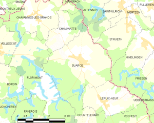
Lepuix-Neuf (Lepuix-Neuf)
- commune in Territoire de Belfort, France
Lepuix-Neuf is a charming village located in the Vosges region of France, known for its stunning landscapes and outdoor activities, making it a great destination for hiking enthusiasts. Here’s what you can expect while hiking in and around Lepuix-Neuf:
Trails and Routes
- Variety of Trails: The region offers a range of trails suitable for various skill levels, from easy walks for beginners to more challenging hikes for experienced adventurers.
- Scenic Views: Many trails provide breathtaking views of the Vosges mountains, valleys, and forests. Look for trails that lead to viewpoints or summits for the best panoramas.
- Natural Features: Hikers can explore diverse ecosystems, including lush forests, rocky outcrops, and alpine meadows. Keep an eye out for local flora and fauna.
Popular Hiking Areas
- Grand Ballon: Close to Lepuix-Neuf, this prominent peak is part of the Haut-Rhin department and offers several hiking trails with varying difficulties. The summit provides exceptional vistas.
- Les Vosges Regional Natural Park: The park offers a network of trails that showcase the region's natural beauty, including waterfalls, lakes, and historic sites.
Practical Tips
- Trail Maps: Before heading out, obtain a trail map from local tourist offices or online resources to familiarize yourself with the area and available trails.
- Weather Conditions: Weather in the Vosges can change rapidly, so check forecasts and prepare accordingly with appropriate clothing and gear.
- Equipment: Sturdy hiking boots, plenty of water, snacks, and sun protection are essential for a successful hike.
Local Culture
Immerse yourself in the local culture by stopping in nearby villages for traditional Alsatian cuisine after your hikes. It’s a great way to relax and appreciate the unique charm of the region.
Conclusion
Hiking in Lepuix-Neuf offers a wonderful opportunity to connect with nature while enjoying the beauty of the Vosges mountains. Plan your trip according to your skill level and interests, and you’re sure to have an unforgettable experience!
- Country:

- Postal Code: 90100
- Coordinates: 47° 32' 24" N, 7° 5' 58" E


- GPS tracks (wikiloc): [Link]
- Area: 5.46 sq km
- Population: 295
- Wikipedia en: wiki(en)
- Wikipedia: wiki(fr)
- Wikidata storage: Wikidata: Q646509
- Wikipedia Commons Category: [Link]
- Freebase ID: [/m/03mhfdx]
- Freebase ID: [/m/03mhfdx]
- Freebase ID: [/m/03mhfdx]
- GeoNames ID: Alt: [6451913]
- GeoNames ID: Alt: [6451913]
- GeoNames ID: Alt: [6451913]
- SIREN number: [219000643]
- SIREN number: [219000643]
- SIREN number: [219000643]
- BnF ID: [15280005k]
- BnF ID: [15280005k]
- BnF ID: [15280005k]
- INSEE municipality code: 90064
- INSEE municipality code: 90064
- INSEE municipality code: 90064
Shares border with regions:


Friesen
- commune in Haut-Rhin, France
It seems like you might be referring to Friesen, but there isn't a widely recognized hiking destination by that name. It's possible that you are referring to a specific region in a country, a local area, or even a trail that may not be well-known....
- Country:

- Postal Code: 68580
- Coordinates: 47° 33' 54" N, 7° 9' 1" E


- GPS tracks (wikiloc): [Link]
- Area: 8.42 sq km
- Population: 634


Hindlingen
- commune in Haut-Rhin, France
Hindlingen is a lesser-known destination for hiking enthusiasts, likely appealing to those looking for less crowded trails and a chance to connect with nature. While I don't have specific information about hiking trails in Hindlingen itself, here are some general tips for hiking in less-explored areas:...
- Country:

- Postal Code: 68580
- Coordinates: 47° 34' 18" N, 7° 8' 14" E


- GPS tracks (wikiloc): [Link]
- Area: 8 sq km
- Population: 649


Ueberstrass
- commune in Haut-Rhin, France
Ueberstrass is a charming area located in Switzerland, known for its scenic landscapes and hiking opportunities. This region is perfect for hikers of various skill levels, offering trails that range from easy walks to more challenging hikes....
- Country:

- Postal Code: 68580
- Coordinates: 47° 33' 9" N, 7° 9' 29" E


- GPS tracks (wikiloc): [Link]
- Area: 5.12 sq km
- Population: 375

Réchésy
- commune in Territoire de Belfort, France
Réchésy is a small locality in the region of France, specifically in the Bourgogne-Franche-Comté area. While it may not be as widely known as some other hiking destinations, it is surrounded by beautiful landscapes and natural features that can appeal to hikers....
- Country:

- Postal Code: 90370
- Coordinates: 47° 30' 30" N, 7° 6' 47" E


- GPS tracks (wikiloc): [Link]
- Area: 12.61 sq km
- Population: 806
- Web site: [Link]


Courtelevant
- commune in Territoire de Belfort, France
Courtelevant, located in the picturesque region of Switzerland, offers numerous opportunities for hiking enthusiasts. The area is known for its stunning landscapes, including rolling hills, dense forests, and sweeping views of the surrounding mountains....
- Country:

- Postal Code: 90100
- Coordinates: 47° 31' 2" N, 7° 4' 48" E


- GPS tracks (wikiloc): [Link]
- Area: 5.82 sq km
- Population: 431


Suarce
- commune in Territoire de Belfort, France
Suarce is a charming destination for hiking enthusiasts in the Auvergne region of France. The area offers a variety of trails that cater to different skill levels, making it suitable for both beginners and experienced hikers. Here are some highlights of hiking in Suarce:...
- Country:

- Postal Code: 90100
- Coordinates: 47° 33' 49" N, 7° 4' 53" E


- GPS tracks (wikiloc): [Link]
- Area: 11.81 sq km
- Population: 448

