Les Vignes (Les Vignes)

- former commune in Lozère, France
- Country:

- Postal Code: 48210
- Coordinates: 44° 16' 40" N, 3° 13' 38" E


- GPS tracks (wikiloc): [Link]
- Area: 28.84 sq km
- Population: 101
- Wikipedia en: wiki(en)
- Wikipedia: wiki(fr)
- Wikidata storage: Wikidata: Q686019
- Wikipedia Commons Category: [Link]
- Freebase ID: [/m/02w96tr]
- Freebase ID: [/m/02w96tr]
- GeoNames ID: Alt: [6456056]
- GeoNames ID: Alt: [6456056]
- BnF ID: [15261598m]
- BnF ID: [15261598m]
- INSEE municipality code: 48195
- INSEE municipality code: 48195
Shares border with regions:

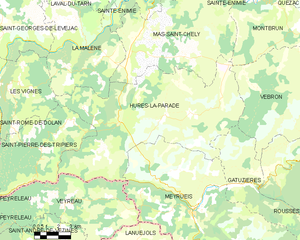
Hures-la-Parade
- commune in Lozère, France
- Country:
- Postal Code: 48150
- Coordinates: 44° 14' 41" N, 3° 21' 9" E
- GPS tracks (wikiloc): [Link]
- AboveSeaLevel: 1000 м m
- Area: 88.59 sq km
- Population: 274

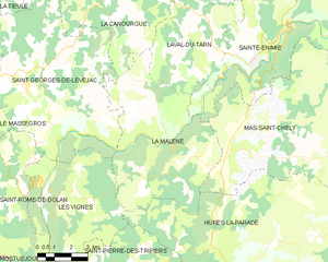
La Malène
- commune in Lozère, France
- Country:
- Postal Code: 48210
- Coordinates: 44° 18' 9" N, 3° 19' 13" E
- GPS tracks (wikiloc): [Link]
- Area: 40.68 sq km
- Population: 148
- Web site: [Link]


Saint-Georges-de-Lévéjac
- former commune in Lozère, France
- Country:
- Postal Code: 48500
- Coordinates: 44° 19' 9" N, 3° 13' 51" E
- GPS tracks (wikiloc): [Link]
- Area: 56.26 sq km
- Population: 250
- Web site: [Link]

Saint-Pierre-des-Tripiers
- commune in Lozère, France
- Country:
- Postal Code: 48150
- Coordinates: 44° 11' 58" N, 3° 15' 28" E
- GPS tracks (wikiloc): [Link]
- Area: 34.74 sq km
- Population: 80

Saint-Rome-de-Dolan
- former commune in Lozère, France
- Country:
- Postal Code: 48500
- Coordinates: 44° 16' 25" N, 3° 12' 57" E
- GPS tracks (wikiloc): [Link]
- Area: 32.63 sq km
- Population: 64