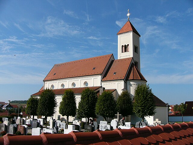
Mörnsheim (Mörnsheim)

- municipality of Germany
 Hiking in Mörnsheim
Mörnsheim is a small town located in thebeautiful Altmühltal region of Bavaria, Germany, known for its stunning landscapes, rich history, and excellent hiking opportunities. The area is characterized by limestone hills, deep valleys, and the picturesque Altmühl River, making it a perfect destination for outdoor enthusiasts.
Hiking Trails in Mörnsheim
-
Altmühltal Panoramaweg: This is one of the most popular long-distance hiking trails in the region. It offers stunning views of the Altmühl Valley and showcases the unique geology and natural beauty of the area. The trail is well-marked and can be tackled in sections.
-
Local Hiking Circuits: There are several shorter circular trails around Mörnsheim that cater to various fitness levels. These trails often lead to scenic viewpoints, historical sites, and local attractions, such as castles and quaint villages.
-
Natuurpark Altmühltal: This nature park offers many well-maintained hiking paths and opportunities for wildlife observation. The park is home to diverse flora and fauna and beautiful geological formations, ensuring an enriching experience for hikers.
-
Cycling and Walking Routes: In addition to hiking, Mörnsheim is connected to various cycling paths that can also be explored on foot. These routes offer a different perspective of the area and are often less crowded than the main hiking trails.
Tips for Hiking in Mörnsheim
- Preparation: Check the weather forecast before you set out and dress appropriately for changing conditions. The terrain may vary, so sturdy hiking shoes are recommended.
- Maps and Guides: While many trails are well-marked, it can be a good idea to carry a map or download a hiking app with offline capabilities just in case.
- Water and Snacks: Always carry enough water and snacks, especially if you plan to hike for several hours. There are limited facilities along some of the trails.
- Leave No Trace: Respect nature by following Leave No Trace principles. Take your trash with you and stay on marked paths to protect the local environment.
Nearby Attractions
- Burg Mörnsheim: The ruins of the local castle provide a great stop for history lovers and an excellent viewpoint over the surrounding landscape.
- Local Towns: Consider visiting nearby towns and villages like Solnhofen or Eichstätt for a taste of local culture and history.
Hiking in Mörnsheim and the surrounding Altmühltal region offers a wonderful way to explore the scenic beauty and historical significance of Bavaria. Whether you are an experienced hiker or a casual walker, you'll find trails that suit your interests and fitness level.
- Country:

- Postal Code: 91804
- Local Dialing Code: 09145
- Licence Plate Code: EI
- Coordinates: 48° 52' 59" N, 11° 0' 0" E


- GPS tracks (wikiloc): [Link]
- AboveSeaLevel: 408 м m
- Area: 33.48 sq km
- Population: 1862
- Web site: http://www.moernsheim.de
- Wikipedia en: wiki(en)
- Wikipedia: wiki(de)
- Wikidata storage: Wikidata: Q512114
- Wikipedia Commons Category: [Link]
- Freebase ID: [/m/02q1g90]
- GeoNames ID: Alt: [2869205]
- VIAF ID: Alt: [239183169]
- OSM relation ID: [943554]
- GND ID: Alt: [4454026-7]
- archINFORM location ID: [5660]
- Historical Gazetteer (GOV) ID: [MOREIMJN58MV]
- Bavarikon ID: [ODB_A00001030]
- German municipality key: 09176148
Shares border with regions:
Tagmersheim
- municipality of Germany
Hiking in Tagmersheim
Tagmersheim is a lovely village located in Bavaria, Germany, that offers a range of hiking opportunities for outdoor enthusiasts. Nestled in a picturesque landscape, it provides access to scenic trails that showcase the region’s natural beauty....
- Country:
- Postal Code: 86704
- Local Dialing Code: 09094
- Licence Plate Code: DON
- Coordinates: 48° 49' 0" N, 10° 58' 0" E
- GPS tracks (wikiloc): [Link]
- AboveSeaLevel: 500 м m
- Area: 15.94 sq km
- Population: 1025
- Web site: [Link]

Rögling
- municipality of Germany
Hiking in Rögling
Rögling is not widely recognized as a hiking destination, so it's possible you may be referring to a lesser-known area or a specific locality. If you meant Röglingen in Germany or another location, I'd be happy to provide general advice and insights about hiking in typical regions characterized by similar landscapes....
- Country:
- Postal Code: 86703
- Local Dialing Code: 09094
- Licence Plate Code: DON
- Coordinates: 48° 51' 0" N, 10° 57' 0" E
- GPS tracks (wikiloc): [Link]
- AboveSeaLevel: 530 м m
- Area: 10.74 sq km
- Population: 676
- Web site: [Link]

Monheim
- municipality in Bavaria, Germany
Hiking in Monheim
Monheim, located in Bavaria, Germany, is a charming small town that offers various outdoor activities, including hiking. The region surrounding Monheim is characterized by beautiful landscapes, rolling hills, and lush forests, making it a great destination for nature enthusiasts....
- Country:
- Postal Code: 86653
- Local Dialing Code: 09091
- Licence Plate Code: DON
- Coordinates: 48° 50' 0" N, 10° 50' 0" E
- GPS tracks (wikiloc): [Link]
- AboveSeaLevel: 495 м m
- Area: 69.35 sq km
- Population: 4123
- Web site: [Link]


Rennertshofen
- municipality of Germany
Hiking in Rennertshofen
Rennertshofen is a charming village located in Bavaria, Germany, and it serves as a great starting point for various hiking adventures. The region features beautiful landscapes, rolling hills, and scenic countryside that appeal to outdoor enthusiasts....
- Country:
- Postal Code: 86643
- Local Dialing Code: 08434
- Licence Plate Code: ND
- Coordinates: 48° 45' 0" N, 11° 2' 0" E
- GPS tracks (wikiloc): [Link]
- AboveSeaLevel: 394 м m
- Area: 93.07 sq km
- Population: 4221
- Web site: [Link]


Wellheim
- municipality of Germany
Hiking in Wellheim
Wellheim, located in Bavaria, Germany, is a scenic destination that offers a variety of hiking opportunities. It is surrounded by beautiful natural landscapes, including forests, hills, and rivers, making it an ideal spot for outdoor enthusiasts. Here are some highlights for hiking in Wellheim:...
- Country:
- Postal Code: 91809
- Local Dialing Code: 08427
- Licence Plate Code: EI
- Coordinates: 48° 48' 0" N, 11° 6' 0" E
- GPS tracks (wikiloc): [Link]
- AboveSeaLevel: 400 м m
- Area: 33.81 sq km
- Population: 2489
- Web site: [Link]


Dollnstein
- municipality of Germany
Hiking in Dollnstein
Dollnstein is a charming village located in Bavaria, Germany, nestled along the banks of the Altmühl River. The area is known for its stunning landscapes, beautiful limestone cliffs, and rich history, making it an excellent destination for hiking enthusiasts. Here are some key points about hiking in Dollnstein:...
- Country:
- Postal Code: 91795
- Local Dialing Code: 08422
- Licence Plate Code: EI
- Coordinates: 48° 52' 0" N, 11° 4' 0" E
- GPS tracks (wikiloc): [Link]
- AboveSeaLevel: 395 м m
- Area: 40.55 sq km
- Population: 2342
- Web site: [Link]

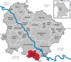
Langenaltheim
- municipality in Germany
Hiking in Langenaltheim
Langenaltheim is a small village located in Bavaria, Germany, and is surrounded by beautiful natural landscapes, making it a great spot for hiking enthusiasts. The region features rolling hills, forests, and picturesque views of the surrounding countryside....
- Country:
- Postal Code: 91788; 91799
- Local Dialing Code: 09145
- Licence Plate Code: WUG
- Coordinates: 48° 54' 0" N, 10° 56' 0" E
- GPS tracks (wikiloc): [Link]
- AboveSeaLevel: 555 м m
- Area: 39.05 sq km
- Population: 2258
- Web site: [Link]


Solnhofen
- municipality of Germany
Hiking in Solnhofen
Solnhofen is a small town located in Bavaria, Germany, known primarily for its stunning natural landscapes and historical significance, particularly regarding the famous Solnhofen limestone that has preserved many Jurassic fossils. Hiking in and around Solnhofen offers an array of beautiful routes, fascinating geological features, and pleasant scenery....
- Country:
- Postal Code: 91807
- Local Dialing Code: 09145
- Licence Plate Code: WUG
- Coordinates: 48° 53' 0" N, 11° 0' 0" E
- GPS tracks (wikiloc): [Link]
- AboveSeaLevel: 408 м m
- Area: 13.5 sq km
- Population: 1740
- Web site: [Link]

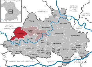
Schernfeld
- municipality of Germany
Hiking in Schernfeld
Schernfeld, located in Bavaria, Germany, is a charming area surrounded by picturesque landscapes, making it a great location for hiking enthusiasts. The region offers a combination of scenic routes that cater to various skill levels, from leisurely walks to more challenging trails....
- Country:
- Postal Code: 85132
- Local Dialing Code: 08422; 08421
- Licence Plate Code: EI
- Coordinates: 48° 54' 0" N, 11° 6' 0" E
- GPS tracks (wikiloc): [Link]
- AboveSeaLevel: 548 м m
- Area: 52.22 sq km
- Population: 3181
- Web site: [Link]