Mazangé (Mazangé)

- commune in Loir-et-Cher, France
- Country:

- Postal Code: 41100
- Coordinates: 47° 49' 26" N, 0° 56' 44" E


- GPS tracks (wikiloc): [Link]
- Area: 24.26 sq km
- Population: 894
- Wikipedia en: wiki(en)
- Wikipedia: wiki(fr)
- Wikidata storage: Wikidata: Q1170524
- Wikipedia Commons Category: [Link]
- Freebase ID: [/m/03nw0jg]
- GeoNames ID: Alt: [2994897]
- SIREN number: [214101313]
- INSEE municipality code: 41131
Shares border with regions:


Villiers-sur-Loir
- commune in Loir-et-Cher, France
- Country:
- Postal Code: 41100
- Coordinates: 47° 48' 24" N, 0° 59' 39" E
- GPS tracks (wikiloc): [Link]
- Area: 10 sq km
- Population: 1132
- Web site: [Link]
Fortan
- commune in Loir-et-Cher, France
- Country:
- Postal Code: 41360
- Coordinates: 47° 50' 44" N, 0° 54' 57" E
- GPS tracks (wikiloc): [Link]
- Area: 5.98 sq km
- Population: 283


Azé
- commune in Loir-et-Cher, France
- Country:
- Postal Code: 41100
- Coordinates: 47° 51' 4" N, 0° 59' 55" E
- GPS tracks (wikiloc): [Link]
- AboveSeaLevel: 81 м m
- Area: 31.93 sq km
- Population: 1090

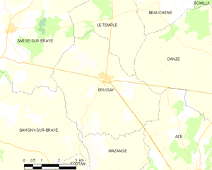
Épuisay
- commune in Loir-et-Cher, France
- Country:
- Postal Code: 41360
- Coordinates: 47° 54' 1" N, 0° 55' 53" E
- GPS tracks (wikiloc): [Link]
- Area: 23.52 sq km
- Population: 819

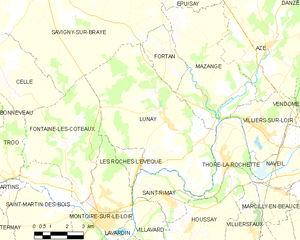
Lunay
- commune in Loir-et-Cher, France
- Country:
- Postal Code: 41360
- Coordinates: 47° 48' 33" N, 0° 54' 55" E
- GPS tracks (wikiloc): [Link]
- Area: 38.63 sq km
- Population: 1276
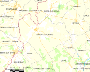
Savigny-sur-Braye
- commune in Loir-et-Cher, France
- Country:
- Postal Code: 41360
- Coordinates: 47° 52' 46" N, 0° 48' 33" E
- GPS tracks (wikiloc): [Link]
- Area: 67.18 sq km
- Population: 2072
- Web site: [Link]

Thoré-la-Rochette
- commune in Loir-et-Cher, France
- Country:
- Postal Code: 41100
- Coordinates: 47° 47' 20" N, 0° 57' 53" E
- GPS tracks (wikiloc): [Link]
- Area: 10.78 sq km
- Population: 885