Azé (Azé)

- commune in Loir-et-Cher, France
- Country:

- Postal Code: 41100
- Coordinates: 47° 51' 4" N, 0° 59' 55" E


- GPS tracks (wikiloc): [Link]
- AboveSeaLevel: 81 м m
- Area: 31.93 sq km
- Population: 1090
- Wikipedia en: wiki(en)
- Wikipedia: wiki(fr)
- Wikidata storage: Wikidata: Q1135658
- Wikipedia Commons Category: [Link]
- Freebase ID: [/m/03qd25y]
- GeoNames ID: Alt: [6616743]
- SIREN number: [214100109]
- BnF ID: [15259286h]
- INSEE municipality code: 41010
Shares border with regions:


Villiers-sur-Loir
- commune in Loir-et-Cher, France
- Country:
- Postal Code: 41100
- Coordinates: 47° 48' 24" N, 0° 59' 39" E
- GPS tracks (wikiloc): [Link]
- Area: 10 sq km
- Population: 1132
- Web site: [Link]

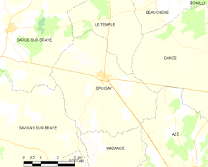
Épuisay
- commune in Loir-et-Cher, France
- Country:
- Postal Code: 41360
- Coordinates: 47° 54' 1" N, 0° 55' 53" E
- GPS tracks (wikiloc): [Link]
- Area: 23.52 sq km
- Population: 819
Saint-Ouen
- commune in Loir-et-Cher, France
- Country:
- Postal Code: 41100
- Coordinates: 47° 48' 39" N, 1° 5' 3" E
- GPS tracks (wikiloc): [Link]
- Area: 11.3 sq km
- Population: 3286

Mazangé
- commune in Loir-et-Cher, France
- Country:
- Postal Code: 41100
- Coordinates: 47° 49' 26" N, 0° 56' 44" E
- GPS tracks (wikiloc): [Link]
- Area: 24.26 sq km
- Population: 894
Rahart
- commune in Loir-et-Cher, France
- Country:
- Postal Code: 41160
- Coordinates: 47° 52' 12" N, 1° 4' 3" E
- GPS tracks (wikiloc): [Link]
- Area: 14.23 sq km
- Population: 313


Vendôme
- commune in Loir-et-Cher, France
- Country:
- Postal Code: 41100
- Coordinates: 47° 47' 34" N, 1° 3' 56" E
- GPS tracks (wikiloc): [Link]
- AboveSeaLevel: 82 м m
- Area: 23.89 sq km
- Population: 16716
- Web site: [Link]

Danzé
- commune in Loir-et-Cher, France
- Country:
- Postal Code: 41160
- Coordinates: 47° 53' 35" N, 1° 1' 40" E
- GPS tracks (wikiloc): [Link]
- Area: 42.26 sq km
- Population: 705