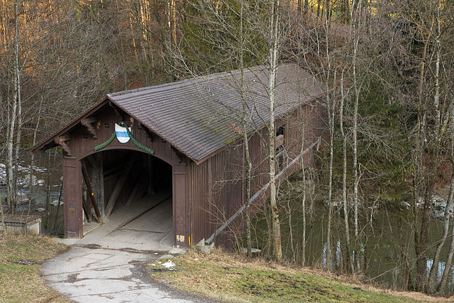
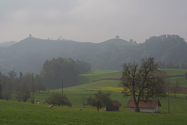
Menzingen (Menzingen)

- municipality in Switzerland
 Hiking in Menzingen
Menzingen is a charming municipality located in the Canton of Zug, Switzerland. It is surrounded by beautiful nature and rolling hills, making it an ideal location for hiking enthusiasts. Here are some highlights and tips for hiking in Menzingen:
Hiking Trails
-
Zugerberg Trail: This trail offers stunning panoramic views of Lake Zug and the surrounding mountains. The route is well-marked and suitable for various skill levels, making it a great choice for families and casual hikers.
-
Hohes Lied Trail: This is a moderately challenging hike that takes you through lush forests and offers beautiful views of the Zugersee. Watch for local wildlife as you traverse the area!
-
Waldweg Routes: Menzingen has several forest trails that provide a serene hiking experience. These paths are ideal for a leisurely walk or a jog amidst fresh air and greenery.
Scenic Views
- The region showcases breathtaking vistas of nearby peaks such as Mount Pilatus and Mount Rigi. Don't forget your camera for some unforgettable photos!
Flora and Fauna
- Menzingen is home to a diverse range of plant and animal life. Be on the lookout for various bird species and wildflowers, especially during the spring and summer months.
Facilities
- Menzingen has various starting points for hikes, and you can often find facilities such as rest areas and information boards along the trails. There are also restaurants and cafes in the village where you can enjoy local Swiss cuisine after a long day of hiking.
Accessibility
- Menzingen is easily accessible via public transportation from major Swiss cities like Zurich and Zug. It's a great spot for day hikes or weekend getaways.
Safety Tips
- Always check local weather conditions before heading out, and ensure you have the appropriate gear, including sturdy shoes, water, and weather-appropriate clothing.
- It's advisable to let someone know your hiking plans, especially if you're venturing on less-traveled paths.
Menzingen's natural beauty and well-maintained trails make it a fantastic destination for hikers of all levels. Whether you're looking for a short walk or a more strenuous hike, you'll find plenty of options to explore in this picturesque Swiss countryside!
- Country:

- Postal Code: 6313
- Local Dialing Code: 041
- Licence Plate Code: ZG
- Coordinates: 47° 10' 12" N, 8° 36' 11" E


- GPS tracks (wikiloc): [Link]
- AboveSeaLevel: 801 м m
- Area: 27.50 sq km
- Population: 4499
- Web site: http://www.menzingen.ch
- Wikipedia en: wiki(en)
- Wikipedia: wiki(de)
- Wikidata storage: Wikidata: Q66050
- Wikipedia Commons Gallery: [Link]
- Wikipedia Commons Category: [Link]
- Freebase ID: [/m/0b4cqr]
- GeoNames ID: Alt: [7286486]
- OSM relation ID: [1683144]
- HDS ID: [790]
- Swiss municipality code: [1704]
Shares border with regions:

Baar
- municipality in Switzerland
Hiking in Baar
Baar, located in the canton of Zug in Switzerland, offers a variety of hiking opportunities that allow you to enjoy the stunning natural landscapes of the region. The area is characterized by rolling hills, lush forests, and beautiful views of the surrounding mountains and Lake Zug....
- Country:
- Postal Code: 6340
- Local Dialing Code: 041
- Licence Plate Code: ZG
- Coordinates: 47° 11' 44" N, 8° 31' 35" E
- GPS tracks (wikiloc): [Link]
- AboveSeaLevel: 443 м m
- Area: 24.83 sq km
- Population: 24322
- Web site: [Link]

Oberägeri
- municipality in Switzerland
Hiking in Oberägeri
Oberägeri, located in the Canton of Zug in Switzerland, is a beautiful destination for hiking enthusiasts. Nestled between the Ägeri lake and the surrounding hills, it offers a variety of trails that cater to different skill levels and provide stunning views of the Swiss landscape....
- Country:
- Postal Code: 6315
- Local Dialing Code: 041
- Licence Plate Code: ZG
- Coordinates: 47° 8' 9" N, 8° 36' 49" E
- GPS tracks (wikiloc): [Link]
- AboveSeaLevel: 737 м m
- Area: 36.2 sq km
- Population: 6059
- Web site: [Link]

Unterägeri
- municipality in Switzerland
Hiking in Unterägeri
Unterägeri is a picturesque municipality located in the Canton of Zug, Switzerland, surrounded by stunning landscapes and offering fantastic opportunities for hiking enthusiasts. Here are some highlights and points of interest for hiking in and around Unterägeri:...
- Country:
- Postal Code: 6314
- Local Dialing Code: 041
- Licence Plate Code: ZG
- Coordinates: 47° 7' 14" N, 8° 34' 40" E
- GPS tracks (wikiloc): [Link]
- AboveSeaLevel: 763 м m
- Area: 26.7 sq km
- Population: 8689
- Web site: [Link]
Neuheim
- municipality in Switzerland
Hiking in Neuheim
Neuheim, located in the Canton of Zug in Switzerland, offers a variety of beautiful hiking opportunities that showcase the stunning landscapes of the region. The area is characterized by rolling hills, lush forests, and panoramic views of the surrounding mountains and Lake Zug. Here’s a brief overview of what you can expect when hiking in Neuheim:...
- Country:
- Postal Code: 6345
- Local Dialing Code: 041
- Licence Plate Code: ZG
- Coordinates: 47° 12' 24" N, 8° 34' 40" E
- GPS tracks (wikiloc): [Link]
- AboveSeaLevel: 666 м m
- Area: 7.9 sq km
- Population: 2245
- Web site: [Link]

Hirzel
- Village in Switzerland
Hiking in Hirzel
Hirzel is a picturesque village located in the Zurich region of Switzerland, nestled amidst beautiful landscapes that are perfect for hiking enthusiasts. The area is characterized by rolling hills, lush forests, and stunning views of the surrounding Alps and Lake Zurich, making it an ideal destination for both casual walkers and experienced hikers....
- Country:
- Postal Code: 8816
- Local Dialing Code: 01
- Licence Plate Code: ZH
- Coordinates: 47° 13' 1" N, 8° 36' 37" E
- GPS tracks (wikiloc): [Link]
- AboveSeaLevel: 678 м m
- Area: 9.68 sq km
- Population: 2158
- Web site: [Link]


Hütten
- municipality in Switzerland
Hiking in Hütten
Hütten, nestled in the Swiss Alps, is a dream destination for hiking enthusiasts. The region offers stunning views, diverse trails, and a rich cultural heritage associated with the Swiss mountains. Here’s a comprehensive overview of hiking in this picturesque area:...
- Country:
- Postal Code: 8825
- Local Dialing Code: 044
- Licence Plate Code: ZH
- Coordinates: 47° 10' 23" N, 8° 39' 58" E
- GPS tracks (wikiloc): [Link]
- AboveSeaLevel: 741 м m
- Area: 7.24 sq km
- Population: 895
- Web site: [Link]

Schönenberg
- municipality in Switzerland
Hiking in Schönenberg
Schönenberg, located near Zürich, Switzerland, offers a variety of hiking opportunities surrounded by beautiful landscapes and panoramic views of the Zürcher Oberland and Lake Zürich. Here are some highlights to consider when planning a hike in this area:...
- Country:
- Postal Code: 8824
- Local Dialing Code: 044
- Licence Plate Code: ZH
- Coordinates: 47° 11' 38" N, 8° 38' 41" E
- GPS tracks (wikiloc): [Link]
- AboveSeaLevel: 714 м m
- Area: 11.0 sq km
- Population: 1844
- Web site: [Link]


Horgen
- municipality in the canton of Zürich, Switzerland
Hiking in Horgen
Horgen, located on the southern shore of Lake Zurich in Switzerland, offers a variety of hiking opportunities suited for different skill levels and interests. Here are some highlights:...
- Country:
- Postal Code: 8810
- Local Dialing Code: 044; 043
- Licence Plate Code: ZH
- Coordinates: 47° 15' 39" N, 8° 35' 51" E
- GPS tracks (wikiloc): [Link]
- AboveSeaLevel: 415 м m
- Area: 30.75 sq km
- Population: 22476
- Web site: [Link]