Schönenberg (Schönenberg)

- municipality in Switzerland
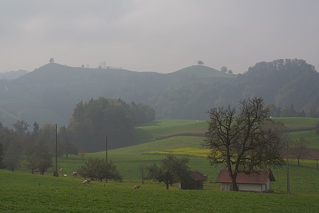
 Hiking in Schönenberg
Schönenberg, located near Zürich, Switzerland, offers a variety of hiking opportunities surrounded by beautiful landscapes and panoramic views of the Zürcher Oberland and Lake Zürich. Here are some highlights to consider when planning a hike in this area:
Scenic Trails
-
Zürich Oberland Trail: This trail provides a fantastic overview of the region’s natural beauty and passes through charming villages, lush forests, and open fields.
-
Schönenberg to Uetliberg: You can hike from Schönenberg to Uetliberg, Zürich’s local mountain. This route offers stunning views of the city, the Alps, and Lake Zürich.
-
Küsnacht ZH: Nearby trails take you along the lake shores and through vineyards, perfect for leisurely walks or more challenging hikes.
Key Features
- Panoramic Views: Many trails in and around Schönenberg afford breathtaking views of the surrounding mountains and Lake Zürich.
- Diverse Flora and Fauna: The area is rich in biodiversity, with various plants and wildlife, making it a great destination for nature lovers.
- Cultural Landmarks: As you hike, you may encounter historical sites and cultural landmarks within the scenic landscape.
Accessibility
- Public Transport: Schönenberg is easily accessible by public transport from Zürich. Trains and buses can drop you off close to several trailheads.
- Trail Marking: Trails are well-marked, following the Swiss hiking trail system, making navigation straightforward for hikers of all levels.
Tips for Hiking in Schönenberg
- Weather Check: Always check the weather before you go as conditions can change rapidly, especially in the mountains.
- Proper Gear: Wear suitable footwear and bring enough water and snacks, especially for longer hikes.
- Respect Nature: Follow local guidelines to preserve the natural environment, including sticking to marked trails and taking all waste with you.
Conclusion
Whether you're a beginner or an experienced hiker, the Schönenberg area offers numerous trails to explore, ranging from gentle walks to more strenuous hikes. Always prepare adequately, and you’ll enjoy a wonderful day out in this picturesque part of Switzerland!
- Country:

- Postal Code: 8824
- Local Dialing Code: 044
- Licence Plate Code: ZH
- Coordinates: 47° 11' 38" N, 8° 38' 41" E


- GPS tracks (wikiloc): [Link]
- AboveSeaLevel: 714 м m
- Area: 11.0 sq km
- Population: 1844
- Web site: http://www.schoenenberg.ch
- Wikipedia en: wiki(en)
- Wikipedia: wiki(de)
- Wikidata storage: Wikidata: Q67528
- Wikipedia Commons Category: [Link]
- Freebase ID: [/m/0gtt8w]
- GeoNames ID: Alt: [7287107]
- OSM relation ID: [1682207]
- HDS ID: [103]
- Swiss municipality code: [0140]
Shares border with regions:

Menzingen
- municipality in Switzerland
Hiking in Menzingen
Menzingen is a charming municipality located in the Canton of Zug, Switzerland. It is surrounded by beautiful nature and rolling hills, making it an ideal location for hiking enthusiasts. Here are some highlights and tips for hiking in Menzingen:...
- Country:
- Postal Code: 6313
- Local Dialing Code: 041
- Licence Plate Code: ZG
- Coordinates: 47° 10' 12" N, 8° 36' 11" E
- GPS tracks (wikiloc): [Link]
- AboveSeaLevel: 801 м m
- Area: 27.50 sq km
- Population: 4499
- Web site: [Link]

Hirzel
- Village in Switzerland
Hiking in Hirzel
Hirzel is a picturesque village located in the Zurich region of Switzerland, nestled amidst beautiful landscapes that are perfect for hiking enthusiasts. The area is characterized by rolling hills, lush forests, and stunning views of the surrounding Alps and Lake Zurich, making it an ideal destination for both casual walkers and experienced hikers....
- Country:
- Postal Code: 8816
- Local Dialing Code: 01
- Licence Plate Code: ZH
- Coordinates: 47° 13' 1" N, 8° 36' 37" E
- GPS tracks (wikiloc): [Link]
- AboveSeaLevel: 678 м m
- Area: 9.68 sq km
- Population: 2158
- Web site: [Link]


Hütten
- municipality in Switzerland
Hiking in Hütten
Hütten, nestled in the Swiss Alps, is a dream destination for hiking enthusiasts. The region offers stunning views, diverse trails, and a rich cultural heritage associated with the Swiss mountains. Here’s a comprehensive overview of hiking in this picturesque area:...
- Country:
- Postal Code: 8825
- Local Dialing Code: 044
- Licence Plate Code: ZH
- Coordinates: 47° 10' 23" N, 8° 39' 58" E
- GPS tracks (wikiloc): [Link]
- AboveSeaLevel: 741 м m
- Area: 7.24 sq km
- Population: 895
- Web site: [Link]


Richterswil
- municipality in Switzerland
Hiking in Richterswil
Richterswil, located on the shores of Lake Zurich in Switzerland, offers a range of hiking opportunities that showcase the region's natural beauty and scenic landscapes. Here are some highlights for hiking in and around Richterswil:...
- Country:
- Postal Code: 8805
- Local Dialing Code: 043; 044
- Licence Plate Code: ZH
- Coordinates: 47° 12' 29" N, 8° 42' 21" E
- GPS tracks (wikiloc): [Link]
- AboveSeaLevel: 588 м m
- Area: 7.54 sq km
- Population: 13407
- Web site: [Link]


Wädenswil
- municipality in the canton of Zürich, Switzerland
Hiking in Wädenswil
Wädenswil, located on the shores of Lake Zurich in Switzerland, offers beautiful hiking trails that suit various skill levels and provide stunning views of both the lake and the surrounding mountains. Here are some highlights and popular trails in and around Wädenswil:...
- Country:
- Postal Code: 8833
- Local Dialing Code: 044; 043
- Licence Plate Code: ZH
- Coordinates: 47° 13' 30" N, 8° 39' 7" E
- GPS tracks (wikiloc): [Link]
- AboveSeaLevel: 597 м m
- Area: 17.37 sq km
- Population: 21716
- Web site: [Link]