Montferrand-le-Château (Montferrand-le-Château)

- commune in Doubs, France
 Hiking in Montferrand-le-Château
Montferrand-le-Château, located near the city of Besançon in the Franche-Comté region of France, offers a range of hiking opportunities that showcase the natural beauty of the area. The region is characterized by its rolling hills, forests, and panoramic views, making it an ideal location for both casual hikers and more experienced outdoor enthusiasts.
Hiking Trails
-
Local Trails: There are several marked hiking trails around Montferrand-le-Château that vary in difficulty. Some trails might take you through wooded areas, while others provide scenic views of the surrounding countryside.
-
Les Boucles de la Loue: This series of circuits along the Loue River provides longer routes, with some paths leading to picturesque spots. The trails are usually well-maintained and offer diverse landscapes, including riverbanks and hillside paths.
Scenic Views
Hiking in this region offers beautiful landscapes, especially during the spring and autumn months when the foliage changes. On clear days, you might even catch glimpses of Besançon and the historic citadel from certain viewpoints.
Wildlife
The area around Montferrand-le-Château is home to a variety of wildlife. As you hike, you might spot deer, a range of birds, and diverse plant life, adding to the richness of the hiking experience.
Tips for Hikers
- Weather: Check the weather before heading out, as conditions can change rapidly in the region.
- Footwear: Wear good hiking boots to tackle uneven terrain comfortably.
- Safety: Make sure to inform someone of your planned route and estimated return time, especially if you are hiking solo.
- Local Maps: Consider picking up a local hiking map or guide, which may provide additional details on trail conditions and lengths.
Accessibility
Montferrand-le-Château is easily accessible from Besançon, making it a convenient spot for both locals and visitors. Public transportation options and parking facilities are available, allowing for a comfortable hiking experience.
In summary, Montferrand-le-Château provides a lovely setting for hiking, with diverse trails, stunning scenery, and opportunities to enjoy the natural environment. Whether you're a novice or a seasoned hiker, you'll find trails that match your skill level and interests.
- Country:

- Postal Code: 25320
- Coordinates: 47° 10' 59" N, 5° 54' 28" E


- GPS tracks (wikiloc): [Link]
- Area: 7.48 sq km
- Population: 2086
- Web site: http://www.montferrand-le-chateau.fr
- Wikipedia en: wiki(en)
- Wikipedia: wiki(fr)
- Wikidata storage: Wikidata: Q906617
- Wikipedia Commons Category: [Link]
- Freebase ID: [/m/03mgbzl]
- Freebase ID: [/m/03mgbzl]
- GeoNames ID: Alt: [2992607]
- GeoNames ID: Alt: [2992607]
- SIREN number: [212503973]
- SIREN number: [212503973]
- BnF ID: [152526231]
- BnF ID: [152526231]
- PACTOLS thesaurus ID: [pcrtgGyYeemZ88]
- PACTOLS thesaurus ID: [pcrtgGyYeemZ88]
- INSEE municipality code: 25397
- INSEE municipality code: 25397
Shares border with regions:

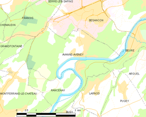
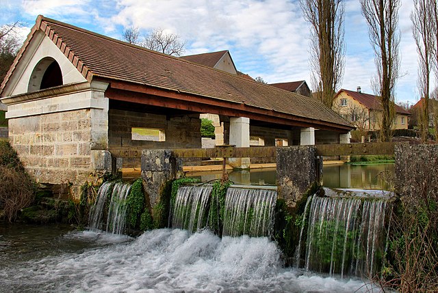
Avanne-Aveney
- commune in Doubs, France
Hiking in Avanne-Aveney
Avanne-Aveney is a picturesque area in the Jura region of France, known for its beautiful landscapes and outdoor activities, including hiking. Here are some highlights and tips for hiking in this area:...
- Country:
- Postal Code: 25720
- Coordinates: 47° 12' 8" N, 5° 57' 51" E
- GPS tracks (wikiloc): [Link]
- AboveSeaLevel: 232 м m
- Area: 8.62 sq km
- Population: 2277
- Web site: [Link]

Grandfontaine
- commune in Doubs, France
Hiking in Grandfontaine
Grandfontaine, located in the Doubs department of France, is a picturesque area that offers a range of hiking opportunities amidst beautiful natural scenery. This region is part of the Jura Mountains, characterized by lush forests, rolling hills, and stunning views. Here are some key highlights for hiking in Grandfontaine:...
- Country:
- Postal Code: 25320
- Coordinates: 47° 11' 51" N, 5° 54' 2" E
- GPS tracks (wikiloc): [Link]
- Area: 5.68 sq km
- Population: 1539
- Web site: [Link]

Thoraise
- commune in Doubs, France
Hiking in Thoraise
Thoraise is a charming location in France, situated near the city of Besançon in the Bourgogne-Franche-Comté region. While it may not be a widely known hiking destination, the surrounding area offers beautiful landscapes and a variety of trails that cater to hikers of different abilities....
- Country:
- Postal Code: 25320
- Coordinates: 47° 10' 26" N, 5° 54' 11" E
- GPS tracks (wikiloc): [Link]
- Area: 3.99 sq km
- Population: 353


Rancenay
- commune in Doubs, France
Hiking in Rancenay
Rancenay is a small commune located in the Doubs department in the Bourgogne-Franche-Comté region of eastern France. The area is known for its beautiful natural landscapes, making it a great destination for hiking and outdoor activities. Here are some highlights about hiking in Rancenay:...
- Country:
- Postal Code: 25320
- Coordinates: 47° 11' 13" N, 5° 57' 1" E
- GPS tracks (wikiloc): [Link]
- Area: 3.66 sq km
- Population: 293