Grandfontaine (Grandfontaine)

- commune in Doubs, France
 Hiking in Grandfontaine
Grandfontaine, located in the Doubs department of France, is a picturesque area that offers a range of hiking opportunities amidst beautiful natural scenery. This region is part of the Jura Mountains, characterized by lush forests, rolling hills, and stunning views. Here are some key highlights for hiking in Grandfontaine:
Trails
-
Variety of Trails: Grandfontaine has a variety of trails suitable for all skill levels, from easy walks to more challenging hikes. You can find well-marked paths that cater to both beginners and experienced hikers.
-
Scenic Routes: Many of the trails wind through dense forests, past creeks, waterfalls, and open meadows. The Jura landscape is known for its limestone cliffs, so you may encounter some stunning geological formations.
-
Wildlife Observation: The region is home to diverse flora and fauna. Keep an eye out for local wildlife, including deer, various bird species, and unique plant life.
Starting Points
- Local Towns: Start your hike from the village of Grandfontaine, where you can find information about local trails. Maps and trail guides can often be found in community centers or local tourist information offices.
Best Time to Hike
- Spring and Fall: Spring and fall are ideal times for hiking in Grandfontaine, with pleasant weather and milder temperatures. The changing foliage in autumn provides a stunning backdrop.
Preparation Tips
- Footwear: Wear sturdy hiking boots suitable for uneven terrain.
- Gear: Bring plenty of water, snacks, and a map or GPS device. It’s also wise to have a rain jacket and weather-appropriate clothing.
- Trail Etiquette: Stay on designated paths, respect locals’ private property, and carry out any trash.
Safety Considerations
- Always check the weather forecast before heading out and be prepared for changing conditions, especially in mountainous areas.
- Let someone know your planned route and expected return time.
Conclusion
Hiking in Grandfontaine, Doubs, can be a rewarding outdoor experience, allowing you to immerse yourself in nature and enjoy the beauty of the Jura region. Whether you are looking for a leisurely stroll or a more vigorous hike, there's something for everyone. Enjoy your adventure!
- Country:

- Postal Code: 25320
- Coordinates: 47° 11' 51" N, 5° 54' 2" E


- GPS tracks (wikiloc): [Link]
- Area: 5.68 sq km
- Population: 1539
- Web site: http://www.grandfontaine.fr
- Wikipedia en: wiki(en)
- Wikipedia: wiki(fr)
- Wikidata storage: Wikidata: Q906554
- Wikipedia Commons Category: [Link]
- Freebase ID: [/m/03mh9w0]
- Freebase ID: [/m/03mh9w0]
- GeoNames ID: Alt: [6453852]
- GeoNames ID: Alt: [6453852]
- SIREN number: [212502876]
- SIREN number: [212502876]
- BnF ID: [15252513f]
- BnF ID: [15252513f]
- INSEE municipality code: 25287
- INSEE municipality code: 25287
Shares border with regions:

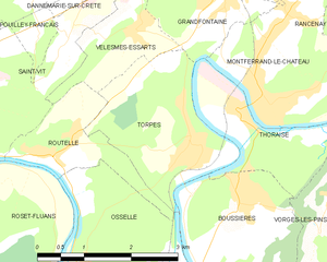
Torpes
- commune in Doubs, France
Hiking in Torpes
Torpes is a charming village located in the Doubs department of France, known for its picturesque landscapes and natural beauty. If you're interested in hiking in and around Torpes, here are some key points to consider:...
- Country:
- Postal Code: 25320
- Coordinates: 47° 10' 9" N, 5° 53' 26" E
- GPS tracks (wikiloc): [Link]
- Area: 5.55 sq km
- Population: 1060
- Web site: [Link]

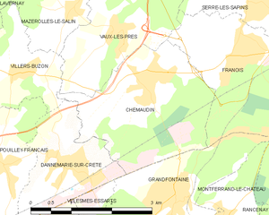
Chemaudin
- former commune in Doubs, France
Hiking in Chemaudin
Chemaudin is a picturesque area known for its beautiful landscapes and hiking trails. While it may not be as widely known as some other hiking destinations, it offers a variety of natural settings and trails suitable for different skill levels....
- Country:
- Postal Code: 25320
- Coordinates: 47° 13' 26" N, 5° 53' 31" E
- GPS tracks (wikiloc): [Link]
- Area: 7.3 sq km
- Population: 1501
- Web site: [Link]


Velesmes-Essarts
- commune in Doubs, France
Hiking in Velesmes-Essarts
Velesmes-Essarts is a charming small commune located in the Doubs department of France. While it may not be as widely known for hiking as some larger regions, it offers an array of beautiful landscapes, lush forests, and scenic routes that are quite appealing to outdoor enthusiasts....
- Country:
- Postal Code: 25410
- Coordinates: 47° 11' 28" N, 5° 52' 29" E
- GPS tracks (wikiloc): [Link]
- Area: 2.92 sq km
- Population: 338


Montferrand-le-Château
- commune in Doubs, France
Hiking in Montferrand-le-Château
Montferrand-le-Château, located near the city of Besançon in the Franche-Comté region of France, offers a range of hiking opportunities that showcase the natural beauty of the area. The region is characterized by its rolling hills, forests, and panoramic views, making it an ideal location for both casual hikers and more experienced outdoor enthusiasts....
- Country:
- Postal Code: 25320
- Coordinates: 47° 10' 59" N, 5° 54' 28" E
- GPS tracks (wikiloc): [Link]
- Area: 7.48 sq km
- Population: 2086
- Web site: [Link]

Thoraise
- commune in Doubs, France
Hiking in Thoraise
Thoraise is a charming location in France, situated near the city of Besançon in the Bourgogne-Franche-Comté region. While it may not be a widely known hiking destination, the surrounding area offers beautiful landscapes and a variety of trails that cater to hikers of different abilities....
- Country:
- Postal Code: 25320
- Coordinates: 47° 10' 26" N, 5° 54' 11" E
- GPS tracks (wikiloc): [Link]
- Area: 3.99 sq km
- Population: 353