Monzuno (Monzuno)
- Italian comune
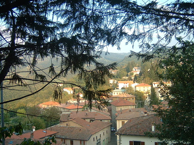
Monzuno is located in the Emilia-Romagna region of Italy, nestled within the beautiful hills of the Apennine Mountains. It’s a wonderful destination for hikers and nature enthusiasts, offering a variety of trails that cater to different skill levels. Here are some highlights to consider when hiking in Monzuno:
Scenic Trails
The area boasts numerous scenic trails that lead through lush forests, rolling hills, and panoramic viewpoints. Some popular trails include:
- Sentiero della Memoria: This trail is significant as it commemorates the historical events of World War II and offers stunning views of the surrounding countryside.
- Monte Venere: A more challenging hike that rewards adventurers with breathtaking vistas and an opportunity to explore diverse flora and fauna.
Wildlife and Nature
Monzuno is home to a rich array of wildlife, including deer, foxes, and various bird species. While hiking, you can also enjoy the diverse plant life, including chestnut trees, oaks, and wildflowers, especially in spring.
Gastronomy and Culture
After a day of hiking, consider sampling the local cuisine. Monzuno offers traditional dishes that highlight ingredients from the region, such as fresh pasta and local cheeses. You might also encounter charming villages where you can experience local culture and hospitality.
Practical Tips
- Weather: Check the forecast before heading out, as the weather can change quickly in the mountains. Dress in layers and be prepared for cooler temperatures, especially in the morning and evening.
- Trail Maps: It’s advisable to have trail maps or a GPS device, as some routes may not be well-marked.
- Local Guides: If you're unfamiliar with the area, consider hiring a local guide. They can provide valuable insights and enhance your hiking experience.
Conservation Respect
As in any natural area, remember to follow the Leave No Trace principles. Stay on marked trails, pack out what you pack in, and respect wildlife and plant life.
Overall, hiking in Monzuno can be a remarkable experience, combining nature, history, and culture in a picturesque setting. Whether you're looking for a leisurely stroll or a challenging trek, Monzuno has something to offer every hiker. Enjoy your adventure!
- Country:

- Postal Code: 40036
- Local Dialing Code: 051
- Licence Plate Code: BO
- Coordinates: 44° 17' 0" N, 11° 16' 0" E


- GPS tracks (wikiloc): [Link]
- AboveSeaLevel: 621 м m
- Area: 65.01 sq km
- Population: 6375
- Web site: http://www.comune.monzuno.bologna.it
- Wikipedia en: wiki(en)
- Wikipedia: wiki(it)
- Wikidata storage: Wikidata: Q94972
- Wikipedia Commons Category: [Link]
- Freebase ID: [/m/0948bc]
- GeoNames ID: Alt: [6536743]
- VIAF ID: Alt: [240524491]
- OSM relation ID: [42983]
- MusicBrainz area ID: [130c415b-f38d-4368-aa85-3ba97a05000a]
- TGN ID: [7052402]
- ISTAT ID: 037044
- Italian cadastre code: F706
Shares border with regions:


Grizzana Morandi
- Italian comune
Grizzana Morandi, located in the Apennine Mountains of northern Italy, offers a wonderful hiking experience surrounded by stunning landscapes, rich flora and fauna, and historical sites. Here are some highlights to consider when hiking in this beautiful area:...
- Country:

- Postal Code: 40030
- Local Dialing Code: 051
- Licence Plate Code: BO
- Coordinates: 44° 15' 0" N, 11° 9' 0" E


- GPS tracks (wikiloc): [Link]
- AboveSeaLevel: 547 м m
- Area: 77 sq km
- Population: 3694
- Web site: [Link]


Loiano
- Italian comune
Loiano is a picturesque town located in the Emilia-Romagna region of Italy, nestled in the Apennine Mountains. It serves as an excellent base for hiking enthusiasts, offering a variety of trails that cater to different skill levels and preferences. Here are some key points to consider when hiking in Loiano:...
- Country:

- Postal Code: 40050
- Local Dialing Code: 051
- Licence Plate Code: BO
- Coordinates: 44° 16' 0" N, 11° 19' 0" E


- GPS tracks (wikiloc): [Link]
- AboveSeaLevel: 714 м m
- Area: 52.41 sq km
- Population: 4288
- Web site: [Link]

Marzabotto
- Italian comune
Marzabotto, located in the Emilia-Romagna region of Italy, is not only known for its historical significance but also offers a variety of hiking opportunities that showcase the region's natural beauty and rich culture....
- Country:

- Postal Code: 40043
- Local Dialing Code: 051
- Licence Plate Code: BO
- Coordinates: 44° 20' 0" N, 11° 12' 0" E


- GPS tracks (wikiloc): [Link]
- AboveSeaLevel: 130 м m
- Area: 74.53 sq km
- Population: 6853
- Web site: [Link]


Monghidoro
- Italian comune
Monghidoro, located in the region of Emilia-Romagna in Italy, offers a variety of hiking opportunities that allow you to explore its beautiful landscapes and rich biodiversity. Here’s what you need to know about hiking in this area:...
- Country:

- Postal Code: 40063
- Local Dialing Code: 051
- Licence Plate Code: BO
- Coordinates: 44° 13' 0" N, 11° 19' 0" E


- GPS tracks (wikiloc): [Link]
- AboveSeaLevel: 841 м m
- Area: 48.29 sq km
- Population: 3689
- Web site: [Link]


Pianoro
- Italian comune
Pianoro, located in the Emilia-Romagna region of Italy, offers a variety of hiking opportunities, characterized by its beautiful landscapes, rolling hills, and charming countryside. The area is not far from the city of Bologna, making it easily accessible for both locals and visitors....
- Country:

- Postal Code: 40065; 40067; 40060
- Local Dialing Code: 051
- Licence Plate Code: BO
- Coordinates: 44° 23' 0" N, 11° 20' 0" E


- GPS tracks (wikiloc): [Link]
- AboveSeaLevel: 200 м m
- Area: 107.13 sq km
- Population: 17503
- Web site: [Link]


San Benedetto Val di Sambro
- Italian comune
 Hiking in San Benedetto Val di Sambro
San Benedetto Val di Sambro, located in the Apennine Mountains of Italy, offers a picturesque setting for hiking enthusiasts. The area is characterized by its lush landscapes, rolling hills, and a diverse range of flora and fauna. Here are some highlights and tips for hiking in this region:...
- Country:

- Postal Code: 40048
- Local Dialing Code: 0534
- Licence Plate Code: BO
- Coordinates: 44° 13' 0" N, 11° 14' 0" E


- GPS tracks (wikiloc): [Link]
- AboveSeaLevel: 602 м m
- Area: 66.47 sq km
- Population: 4198
- Web site: [Link]


Sasso Marconi
- Italian comune
Sasso Marconi, located in the Emilia-Romagna region of Italy, is a great area for hiking enthusiasts. Nestled in the Apennine Mountains, it offers a range of trails suited for different skill levels, with beautiful landscapes that include hills, forests, and panoramic views of the surrounding countryside....
- Country:

- Postal Code: 40037
- Local Dialing Code: 051
- Licence Plate Code: BO
- Coordinates: 44° 24' 0" N, 11° 15' 0" E


- GPS tracks (wikiloc): [Link]
- AboveSeaLevel: 128 м m
- Area: 96.45 sq km
- Population: 14903
- Web site: [Link]
