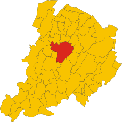
Sasso Marconi (Sasso Marconi)
.svg)
- Italian comune
 Hiking in Sasso Marconi
Sasso Marconi, located in the Emilia-Romagna region of Italy, is a great area for hiking enthusiasts. Nestled in the Apennine Mountains, it offers a range of trails suited for different skill levels, with beautiful landscapes that include hills, forests, and panoramic views of the surrounding countryside.
Here are some highlights and tips for hiking in Sasso Marconi:
Trails and Routes
-
Parco Regionale dei Gessi Bolognesi e Calanchi dell'Abbadessa: Just a short distance from Sasso Marconi, this regional park features trails that wind through striking geological formations and rich biodiversity. The trails can vary in difficulty, making it suitable for both beginners and experienced hikers.
-
Monte Adone: This is a popular hiking destination with trails that lead to the summit, providing spectacular views of the surrounding landscape. The hike can be challenging but is well-marked and offers a rewarding experience at the top.
-
Via degli Dei: A historic long-distance trail connecting Bologna to Florence, portions of this route pass near Sasso Marconi. It's a multi-day trek that offers cultural and historical insights along with beautiful natural scenery.
Best Time to Hike
- Spring and Fall: These seasons typically offer mild weather, making them ideal for hiking. You'll also be able to enjoy blooming wildflowers in spring and stunning autumn foliage.
Tips for Hiking in Sasso Marconi
- Prepare for Variable Weather: Weather can change rapidly in the Apennines, so it’s essential to dress in layers and carry rain gear.
- Hydration and Snacks: Always bring enough water and some snacks to keep your energy levels up during hikes.
- Navigation: Familiarize yourself with the trail maps, or consider downloading offline maps on your smartphone. Marked trails are generally easy to follow, but having a map can help you stay oriented.
- Respect Nature: Follow the Leave No Trace principles to minimize your impact on the environment.
Local Amenities
After a day of hiking, you can explore the town of Sasso Marconi, which offers various local restaurants and shops. Enjoying local cuisine is a great way to relax and recharge after a hike.
Overall, Sasso Marconi is a fantastic destination for those who love hiking and outdoor adventures, offering a mix of natural beauty and cultural experiences.
- Country:

- Postal Code: 40037
- Local Dialing Code: 051
- Licence Plate Code: BO
- Coordinates: 44° 24' 0" N, 11° 15' 0" E


- GPS tracks (wikiloc): [Link]
- AboveSeaLevel: 128 м m
- Area: 96.45 sq km
- Population: 14903
- Web site: http://www.comune.sassomarconi.bologna.it
- Wikipedia en: wiki(en)
- Wikipedia: wiki(it)
- Wikidata storage: Wikidata: Q94997
- Wikipedia Commons Gallery: [Link]
- Wikipedia Commons Category: [Link]
- Freebase ID: [/m/06zsjf]
- GeoNames ID: Alt: [6538477]
- VIAF ID: Alt: [147830361]
- OSM relation ID: [43074]
- WOEID: [12676412]
- UN/LOCODE: [ITSSM]
- ISTAT ID: 037057
- Italian cadastre code: G972
Shares border with regions:
Bologna
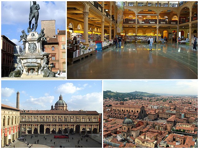
- city in Emilia-Romagna, Italy
Hiking in Bologna
Bologna, known for its rich culture, gastronomy, and history, also offers some lovely opportunities for hiking and outdoor activities in its surrounding areas. Here's a guide to hiking in and around Bologna:...
- Country:
- Postal Code: 40121–40141
- Local Dialing Code: 051
- Licence Plate Code: BO
- Coordinates: 44° 29' 38" N, 11° 20' 34" E
- GPS tracks (wikiloc): [Link]
- AboveSeaLevel: 54 м m
- Area: 140.86 sq km
- Population: 388367
- Web site: [Link]


Casalecchio di Reno
- Italian comune
Hiking in Casalecchio di Reno
Casalecchio di Reno is a town located in the Emilia-Romagna region of Italy, near Bologna. It offers a variety of hiking opportunities, particularly for those interested in combining nature with the charm of local culture....
- Country:
- Postal Code: 40033
- Local Dialing Code: 051
- Licence Plate Code: BO
- Coordinates: 44° 29' 0" N, 11° 17' 0" E
- GPS tracks (wikiloc): [Link]
- AboveSeaLevel: 61 м m
- Area: 17 sq km
- Population: 36456
- Web site: [Link]


Marzabotto
- Italian comune
Hiking in Marzabotto
Marzabotto, located in the Emilia-Romagna region of Italy, is not only known for its historical significance but also offers a variety of hiking opportunities that showcase the region's natural beauty and rich culture....
- Country:
- Postal Code: 40043
- Local Dialing Code: 051
- Licence Plate Code: BO
- Coordinates: 44° 20' 0" N, 11° 12' 0" E
- GPS tracks (wikiloc): [Link]
- AboveSeaLevel: 130 м m
- Area: 74.53 sq km
- Population: 6853
- Web site: [Link]
Monte San Pietro
- Italian comune
Hiking in Monte San Pietro
Monte San Pietro, located in the Emilia-Romagna region of Italy, offers a variety of hiking opportunities for outdoor enthusiasts. The area is characterized by its beautiful landscapes, rolling hills, and picturesque views, making it an ideal spot for both casual walkers and experienced hikers....
- Country:
- Postal Code: 40050
- Local Dialing Code: 051
- Licence Plate Code: BO
- Coordinates: 44° 26' 19" N, 11° 8' 3" E
- GPS tracks (wikiloc): [Link]
- AboveSeaLevel: 112 м m
- Area: 74.69 sq km
- Population: 10960
- Web site: [Link]


Monzuno
- Italian comune
Hiking in Monzuno
Monzuno is located in the Emilia-Romagna region of Italy, nestled within the beautiful hills of the Apennine Mountains. It’s a wonderful destination for hikers and nature enthusiasts, offering a variety of trails that cater to different skill levels. Here are some highlights to consider when hiking in Monzuno:...
- Country:
- Postal Code: 40036
- Local Dialing Code: 051
- Licence Plate Code: BO
- Coordinates: 44° 17' 0" N, 11° 16' 0" E
- GPS tracks (wikiloc): [Link]
- AboveSeaLevel: 621 м m
- Area: 65.01 sq km
- Population: 6375
- Web site: [Link]


Pianoro
- Italian comune
Hiking in Pianoro
Pianoro, located in the Emilia-Romagna region of Italy, offers a variety of hiking opportunities, characterized by its beautiful landscapes, rolling hills, and charming countryside. The area is not far from the city of Bologna, making it easily accessible for both locals and visitors....
- Country:
- Postal Code: 40065; 40067; 40060
- Local Dialing Code: 051
- Licence Plate Code: BO
- Coordinates: 44° 23' 0" N, 11° 20' 0" E
- GPS tracks (wikiloc): [Link]
- AboveSeaLevel: 200 м m
- Area: 107.13 sq km
- Population: 17503
- Web site: [Link]


Zola Predosa
- Italian comune
Hiking in Zola Predosa
Zola Predosa, located in the metropolitan area of Bologna in Italy, offers a variety of hiking opportunities amidst its picturesque landscapes. The area is characterized by rolling hills, vineyards, and olive groves, making it an appealing destination for outdoor enthusiasts. Here are some key points about hiking in Zola Predosa:...
- Country:
- Postal Code: 40069
- Local Dialing Code: 051
- Licence Plate Code: BO
- Coordinates: 44° 29' 18" N, 11° 13' 5" E
- GPS tracks (wikiloc): [Link]
- AboveSeaLevel: 74 м m
- Area: 37 sq km
- Population: 15105
- Web site: [Link]