Morimondo (Morimondo)
- Italian comune
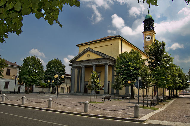
Morimondo is a charming small town located in Lombardy, Italy, known for its historical abbey and serene countryside. While Morimondo is not primarily recognized as a hiking destination, the surrounding area offers beautiful trails that cater to hikers of various skill levels.
Here are some highlights for a hiking experience around Morimondo:
1.
- The area surrounding Morimondo is part of the Ticino Park, which features lush landscapes, rivers, and woodlands. Many trails are well-marked, and you can enjoy peaceful walks along the Ticino River.
2.
- As you hike, take the time to explore the rich history of Morimondo, including the Abbey of Morimondo, which dates back to the 12th century. The abbey’s architecture and the serene atmosphere make for a lovely stop during your hike.
3.
- The gentle hills and rivers provide picturesque views that are perfect for photography and relaxation. Look out for local wildlife and vibrant flora.
4.
- For an easy hike, consider walking along the riverbanks or through the nearby fields. There are also more defined trails that lead to nearby towns such as Abbiategrasso or onto longer circuits that explore more of the Ticino Park.
5.
- Morimondo is accessible by public transportation from Milan, making it an easy day trip for hikers looking to escape the city.
6.
- Spring and fall are ideal for hiking, as the weather is mild, and the landscapes are particularly beautiful with blooming flowers or autumn colors. Summers can be warm, so early morning or late afternoon hikes are recommended.
7.
- Always carry sufficient water and snacks, wear appropriate hiking footwear, and be mindful of the weather conditions. It's also a good idea to have a map or a GPS device if you're venturing off well-trodden paths.
Whether you’re an experienced hiker or just looking for a leisurely stroll, the natural beauty and rich history in and around Morimondo make it a delightful destination for enjoying the outdoors.
- Country:

- Postal Code: 20081
- Local Dialing Code: 02
- Licence Plate Code: MI
- Coordinates: 45° 21' 0" N, 8° 57' 0" E


- GPS tracks (wikiloc): [Link]
- AboveSeaLevel: 109 м m
- Area: 26 sq km
- Population: 1138
- Web site: http://www.comune.morimondo.mi.it
- Wikipedia en: wiki(en)
- Wikipedia: wiki(it)
- Wikidata storage: Wikidata: Q42241
- Wikipedia Commons Category: [Link]
- Freebase ID: [/m/0gj6r4]
- GeoNames ID: Alt: [6537123]
- VIAF ID: Alt: [137650450]
- OSM relation ID: [44710]
- MusicBrainz area ID: [3fe20998-eef2-4868-93d3-974a24d0108f]
- UN/LOCODE: [ITO88]
- ISTAT ID: 015150
- Italian cadastre code: D033
Shares border with regions:
Casorate Primo
- Italian comune
Casorate Primo, located in the Lombardy region of Italy, is not especially renowned for hiking compared to larger natural parks or mountain areas, but it does offer some pleasant opportunities for walking and exploring the surrounding countryside....
- Country:

- Postal Code: 27022
- Local Dialing Code: 02
- Licence Plate Code: PV
- Coordinates: 45° 19' 0" N, 9° 1' 0" E


- GPS tracks (wikiloc): [Link]
- AboveSeaLevel: 103 м m
- Area: 9.74 sq km
- Population: 8680
- Web site: [Link]


Vigevano
- Italian comune
Vigevano, located in the Lombardy region of Italy, is primarily known for its historical architecture and cultural heritage, particularly the stunning Piazza Ducale and the Castello Sforzesco. While Vigevano itself is not predominantly a hiking destination, it is surrounded by beautiful countryside and offers opportunities for various outdoor activities, including walking and cycling....
- Country:

- Postal Code: 27029
- Local Dialing Code: 0381
- Licence Plate Code: PV
- Coordinates: 45° 19' 0" N, 8° 52' 0" E


- GPS tracks (wikiloc): [Link]
- AboveSeaLevel: 116 м m
- Area: 82.27 sq km
- Population: 63505
- Web site: [Link]


Rosate
- Italian comune
Rosate is a small town located in the Lombardy region of Italy, not far from Milan. While it may not be known for extensive hiking trails, the surrounding areas offer several opportunities for outdoor activities and nature exploration. Here are some insights and tips for hiking in and around Rosate:...
- Country:

- Postal Code: 20088
- Local Dialing Code: 02
- Licence Plate Code: MI
- Coordinates: 45° 20' 0" N, 9° 1' 0" E


- GPS tracks (wikiloc): [Link]
- AboveSeaLevel: 107 м m
- Area: 18.68 sq km
- Population: 5762
- Web site: [Link]
Ozzero
- Italian comune
Ozzero, a scenic area potentially located within a region known for its natural beauty, would typically offer a variety of hiking opportunities depending on the local geography and climate. While I don't have specific data about a place called Ozzero, I can help you with general advice on what to expect when hiking in a picturesque area:...
- Country:

- Postal Code: 20080
- Local Dialing Code: 02
- Licence Plate Code: MI
- Coordinates: 45° 22' 0" N, 8° 55' 0" E


- GPS tracks (wikiloc): [Link]
- AboveSeaLevel: 107 м m
- Area: 10.97 sq km
- Population: 1489
- Web site: [Link]


Gudo Visconti
- Italian comune
Gudo Visconti is a small municipality in the Lombardy region of Italy, located not far from Milan. While it may not be as well-known as some other hiking destinations in Italy, it offers a peaceful environment and opportunities for outdoor activities in its surrounding areas....
- Country:

- Postal Code: 20088
- Local Dialing Code: 02
- Licence Plate Code: MI
- Coordinates: 45° 23' 0" N, 9° 0' 0" E


- GPS tracks (wikiloc): [Link]
- AboveSeaLevel: 116 м m
- Area: 6.1 sq km
- Population: 1658
- Web site: [Link]


Vermezzo
- settlement in the italian municipality of Vermezzo con Zelo
Vermezzo is a small town located in the Lombardy region of Italy, known more for its proximity to larger cities like Milan than for extensive hiking networks. However, the surrounding areas offer some opportunities for outdoor activities, including hiking....
- Country:

- Postal Code: 20080
- Local Dialing Code: 02
- Licence Plate Code: MI
- Coordinates: 45° 24' 0" N, 8° 58' 0" E


- GPS tracks (wikiloc): [Link]
- AboveSeaLevel: 111 м m
- Area: 6.31 sq km
- Population: 3931
- Web site: [Link]


Zelo Surrigone
- settlement in the italian municipality of Vermezzo con Zelo
Zelo Surrigone is a small town located in the Lombardy region of Italy, not far from Milan. While it may not be a major tourist destination, it offers access to some beautiful natural surroundings that are perfect for hiking enthusiasts....
- Country:

- Postal Code: 20080
- Local Dialing Code: 02
- Licence Plate Code: MI
- Coordinates: 45° 23' 0" N, 8° 59' 0" E


- GPS tracks (wikiloc): [Link]
- AboveSeaLevel: 113 м m
- Area: 4.43 sq km
- Population: 1842
- Web site: [Link]


Abbiategrasso
- Italian comune
Abbiategassso, a charming town located in the Lombardy region of Italy, offers a variety of hiking opportunities, particularly for those who enjoy scenic trails that meander through beautiful landscapes and cultural sites. Here are some key highlights for hiking in and around Abbiategrasso:...
- Country:

- Postal Code: 20081
- Local Dialing Code: 02
- Licence Plate Code: MI
- Coordinates: 45° 24' 3" N, 8° 55' 7" E


- GPS tracks (wikiloc): [Link]
- AboveSeaLevel: 120 м m
- Area: 47.78 sq km
- Population: 32295
- Web site: [Link]
Bubbiano
- Italian comune
Bubbiano is a small municipality located in the Lombardy region of Italy, near the metropolitan area of Milan. While it may not be a well-known hiking destination, it does offer some scenic countryside and rural landscapes that are ideal for leisurely walks and nature excursions....
- Country:

- Postal Code: 20088
- Local Dialing Code: 02
- Licence Plate Code: MI
- Coordinates: 45° 20' 0" N, 9° 1' 0" E


- GPS tracks (wikiloc): [Link]
- AboveSeaLevel: 106 м m
- Area: 2.95 sq km
- Population: 2401
- Web site: [Link]
Besate
- Italian comune
Besate is a charming municipality located in the Lombardy region of Italy, nestled along the banks of the Ticino River. Its natural surroundings and proximity to the Ticino Regional Park make it a great spot for hiking enthusiasts. While the area may not be as famous as some other hiking destinations in Italy, it offers a variety of trails that showcase beautiful landscapes, local flora and fauna, and serene river views....
- Country:

- Postal Code: 20080
- Local Dialing Code: 02
- Licence Plate Code: MI
- Coordinates: 45° 19' 0" N, 8° 58' 0" E


- GPS tracks (wikiloc): [Link]
- AboveSeaLevel: 104 м m
- Area: 12.74 sq km
- Population: 2064
- Web site: [Link]

