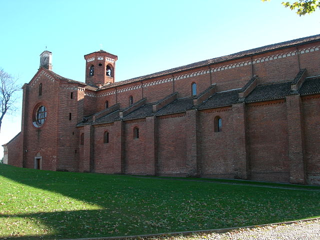
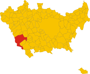
Vermezzo (Vermezzo)
.svg)
- settlement in the italian municipality of Vermezzo con Zelo
 Hiking in Vermezzo
Vermezzo is a small town located in the Lombardy region of Italy, known more for its proximity to larger cities like Milan than for extensive hiking networks. However, the surrounding areas offer some opportunities for outdoor activities, including hiking.
Hiking in and around Vermezzo:
-
Local Trails: While Vermezzo itself may not have dedicated hiking trails, the region boasts some picturesque paths that meander through the nearby countryside. These trails typically allow hikers to experience the charm of the Italian countryside, including vineyards, fields, and small woodlands.
-
Navigli Canals: You can explore the paths along the Navigli canals, which are not far from Vermezzo. There are walking and cycling paths that provide a pleasant way to enjoy the area's unique waterways, picturesque bridges, and historic architecture.
-
Parco Agricolo Sud Milano: To the south of Vermezzo lies the Parco Agricolo Sud Milano, which is a protected agricultural park featuring a range of paths suitable for walking and cycling. The park covers extensive natural and agricultural landscapes—a great place for nature lovers.
-
Day Trips to Regional Parks: If you're willing to venture a bit further, the Ticino Regional Park and the Adda Nord Park are excellent options. They offer marked trails of varying difficulty, scenic views, and a chance to immerse yourself in nature.
Tips for Hiking in the Area:
- Weather: Always check the weather before heading out, as conditions can change quickly in the region.
- Footwear: Wear comfortable and sturdy hiking footwear, especially if you plan to venture onto uneven terrain.
- Local Amenities: Since Vermezzo is small, make sure to bring sufficient water and snacks. Plan meal stops in advance if you expect to spend a long time out.
- Maps and GPS: Some trails might not be well-marked, so carrying a local map or a GPS device can be helpful.
Overall Experience:
While Vermezzo might not be a hiking hotspot, it serves as a lovely starting point for exploring the scenic landscapes of Lombardy. The combination of rich cultural history and natural beauty makes it an appealing option for both casual walkers and dedicated hikers looking for a relaxing experience.
- Country:

- Postal Code: 20080
- Local Dialing Code: 02
- Licence Plate Code: MI
- Coordinates: 45° 24' 0" N, 8° 58' 0" E


- GPS tracks (wikiloc): [Link]
- AboveSeaLevel: 111 м m
- Area: 6.31 sq km
- Population: 3931
- Web site: http://www.comune.vermezzo.mi.it
- Wikipedia en: wiki(en)
- Wikipedia: wiki(it)
- Wikidata storage: Wikidata: Q42548
- Wikipedia Commons Category: [Link]
- Freebase ID: [/m/0gj7_h]
- GeoNames ID: Alt: [6537138]
- VIAF ID: Alt: [246351902]
- OSM relation ID: [44860]
- GND ID: Alt: [7709753-1]
- Quora topic ID: [Vermezzo]
- UN/LOCODE: [ITVMZ]
- ISTAT ID: 015235
- Italian cadastre code: L768
Shares border with regions:


Gaggiano
- Italian comune
Hiking in Gaggiano
Gaggiano, located in the Lombardy region of Italy, is known for its picturesque landscapes and serene surroundings, making it a lovely destination for hiking. Although it may not be a major hiking destination compared to some of the more famous mountains and valleys in Italy, there are still plenty of opportunities for outdoor activities....
- Country:
- Postal Code: 20083
- Local Dialing Code: 02
- Licence Plate Code: MI
- Coordinates: 45° 24' 17" N, 9° 2' 6" E
- GPS tracks (wikiloc): [Link]
- AboveSeaLevel: 117 м m
- Area: 26.26 sq km
- Population: 9131
- Web site: [Link]

Morimondo
- Italian comune
Hiking in Morimondo
Morimondo is a charming small town located in Lombardy, Italy, known for its historical abbey and serene countryside. While Morimondo is not primarily recognized as a hiking destination, the surrounding area offers beautiful trails that cater to hikers of various skill levels....
- Country:
- Postal Code: 20081
- Local Dialing Code: 02
- Licence Plate Code: MI
- Coordinates: 45° 21' 0" N, 8° 57' 0" E
- GPS tracks (wikiloc): [Link]
- AboveSeaLevel: 109 м m
- Area: 26 sq km
- Population: 1138
- Web site: [Link]


Gudo Visconti
- Italian comune
Hiking in Gudo Visconti
Gudo Visconti is a small municipality in the Lombardy region of Italy, located not far from Milan. While it may not be as well-known as some other hiking destinations in Italy, it offers a peaceful environment and opportunities for outdoor activities in its surrounding areas....
- Country:
- Postal Code: 20088
- Local Dialing Code: 02
- Licence Plate Code: MI
- Coordinates: 45° 23' 0" N, 9° 0' 0" E
- GPS tracks (wikiloc): [Link]
- AboveSeaLevel: 116 м m
- Area: 6.1 sq km
- Population: 1658
- Web site: [Link]


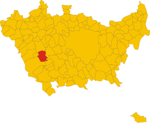
Zelo Surrigone
- settlement in the italian municipality of Vermezzo con Zelo
Hiking in Zelo Surrigone
Zelo Surrigone is a small town located in the Lombardy region of Italy, not far from Milan. While it may not be a major tourist destination, it offers access to some beautiful natural surroundings that are perfect for hiking enthusiasts....
- Country:
- Postal Code: 20080
- Local Dialing Code: 02
- Licence Plate Code: MI
- Coordinates: 45° 23' 0" N, 8° 59' 0" E
- GPS tracks (wikiloc): [Link]
- AboveSeaLevel: 113 м m
- Area: 4.43 sq km
- Population: 1842
- Web site: [Link]

Abbiategrasso
- Italian comune
Hiking in Abbiategrasso
Abbiategassso, a charming town located in the Lombardy region of Italy, offers a variety of hiking opportunities, particularly for those who enjoy scenic trails that meander through beautiful landscapes and cultural sites. Here are some key highlights for hiking in and around Abbiategrasso:...
- Country:
- Postal Code: 20081
- Local Dialing Code: 02
- Licence Plate Code: MI
- Coordinates: 45° 24' 3" N, 8° 55' 7" E
- GPS tracks (wikiloc): [Link]
- AboveSeaLevel: 120 м m
- Area: 47.78 sq km
- Population: 32295
- Web site: [Link]

Albairate
- Italian comune
Hiking in Albairate
Albaitare, a small municipality located in the Lombardy region of Italy, is known for its beautiful landscapes and proximity to nature, making it a delightful place for hiking. Here are some key points to guide you about hiking in this area:...
- Country:
- Postal Code: 20080
- Local Dialing Code: 02
- Licence Plate Code: MI
- Coordinates: 45° 25' 0" N, 8° 56' 0" E
- GPS tracks (wikiloc): [Link]
- AboveSeaLevel: 124 м m
- Area: 14.98 sq km
- Population: 4708
- Web site: [Link]